TopoQuest Logo
Do you find TopoQuest useful?
Help keep TopoQuest running and adding new maps/features by donating!
Bitcoin:  19c7KJd3qBynnjoSw5npx9KScwjBe4ifkT
Litecoin:  LXs6TkuXGGXo1vDsWCkWVdjQX94eUKd6ui
Home View Maps Find Maps Find Places Resources & Links


Shady Dale, Georgia Topographic Map

USGS Map Title: Shady Dale, GA
USGS Map MRC: 33083D5
DRG (GeoTIFF) Download: o33083d5.tif


Neighboring USGS Topographic Map Quads:


  Mansfield, GA  
33083E6
 

  Rutledge South, GA  
33083E5
 

  Madison, GA  
33083E4
 

  Farrar, GA  
33083D6
 

  Shady Dale, GA  
33083D5
 

  Rock Eagle Lake, GA  
33083D4
 

  Monticello, GA  
33083C6
 

  Smithboro, GA  
33083C5
 

  Eatonton, GA  
33083C4


Map MRC Location:

N34°
W84°
N34°
W83°
H8 H7 H6 H5 H4 H3 H2 H1
G8 G7 G6 G5 G4 G3 G2 G1
F8 F7 F6 F5 F4 F3 F2 F1
E8 E7 E6 E5 E4 E3 E2 E1
D8 D7 D6 D5 D4 D3 D2 D1
C8 C7 C6 C5 C4 C3 C2 C1
B8 B7 B6 B5 B4 B3 B2 B1
A8 A7 A6 A5 A4 A3 A2 A1
N33°
W84°
N33°
W83°

Shady Dale, GA USGS 1:24K Topographic Map Preview:
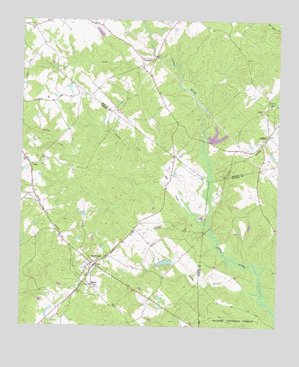
Shady Dale, GA USGS Topographic Map
Click on map above to begin viewing in our Map Viewer.

This topographic map contains these locations and features:
Feature Name Type Latitude Longitude GNIS ID View Map
Antioch Baptist ChurchChurchN33.4629°W83.5079°354353View Map
Athon (historical)Populated PlaceN33.3951°W83.5554°346116View Map
Gap CreekStreamN33.4165°W83.5335°327912View Map
GodfreyPopulated PlaceN33.4535°W83.5049°356040View Map
Godfrey Dairy FarmLocaleN33.4422°W83.5033°2634689View Map
Godfrey DivisionCivilN33.4940°W83.5262°1936289View Map
Hanna BranchStreamN33.3879°W83.5071°328050View Map
Hearnville (historical)Populated PlaceN33.4204°W83.5054°347213View Map
Hearnville Academy (historical)SchoolN33.4207°W83.5054°347214View Map
Hearnville CemeteryCemeteryN33.4201°W83.5046°347215View Map
Hone BranchStreamN33.4224°W83.5332°347216View Map
KellyPopulated PlaceN33.4404°W83.6193°328378View Map
Lynch DamDamN33.4018°W83.5516°336608View Map
Lynch LakeReservoirN33.4011°W83.5547°336609View Map
MachenPopulated PlaceN33.3921°W83.5899°328687View Map
McComb LakeReservoirN33.4918°W83.5866°342287View Map
McComb Lake DamDamN33.4918°W83.5866°342286View Map
Midway ChurchChurchN33.4437°W83.6157°328767View Map
Mobley BridgeBridgeN33.4337°W83.5535°346160View Map
Mobley School (historical)SchoolN33.4410°W83.5516°346161View Map
Morgan County Fire Rescue Department Station 5BuildingN33.4511°W83.5056°2604530View Map
Mount Pleasant ChurchChurchN33.4146°W83.5010°347237View Map
New Enon Baptist ChurchChurchN33.4658°W83.5038°355698View Map
New Enon Baptist Church CemeteryCemeteryN33.4651°W83.5035°2573973View Map
PenningtonPopulated PlaceN33.4848°W83.5607°332637View Map
Pleasant Grove ChurchChurchN33.4975°W83.6198°329253View Map
Pleasant Grove Church CemeteryCemeteryN33.4977°W83.6192°2573988View Map
Providence Baptist ChurchChurchN33.3968°W83.5907°346178View Map
Providence CemeteryCemeteryN33.3965°W83.5907°346179View Map
Shady DalePopulated PlaceN33.4007°W83.5902°329643View Map
Shady Dale DivisionCivilN33.4180°W83.6113°1936534View Map
Shady Dale Fire DepartmentBuildingN33.3974°W83.5918°2603542View Map
Spears Mill (historical)LocaleN33.4860°W83.5602°346027View Map
Town of Shady DaleCivilN33.4008°W83.5881°2407317View Map
Turkey CreekStreamN33.4440°W83.5596°330068View Map
Vason DamDamN33.4535°W83.5366°338607View Map
Vason LakeReservoirN33.4535°W83.5366°338608View Map
Waltons MillLocaleN33.4554°W83.5368°346035View Map

Note: Coordinates in the location and feature list above are referenced to NAD83 datum.


Copyright (C) 2008-2025 Ryan Niemi / Sunset Dynamics ... All Rights Reserved