TopoQuest Logo
Do you find TopoQuest useful?
Help keep TopoQuest running and adding new maps/features by donating!
Bitcoin:  19c7KJd3qBynnjoSw5npx9KScwjBe4ifkT
Litecoin:  LXs6TkuXGGXo1vDsWCkWVdjQX94eUKd6ui
Home View Maps Find Maps Find Places Resources & Links


Rock Eagle Lake, Georgia Topographic Map

USGS Map Title: Rock Eagle Lake, GA
USGS Map MRC: 33083D4
DRG (GeoTIFF) Download: o33083d4.tif


Neighboring USGS Topographic Map Quads:


  Rutledge South, GA  
33083E5
 

  Madison, GA  
33083E4
 

  Buckhead, GA  
33083E3
 

  Shady Dale, GA  
33083D5
 

  Rock Eagle Lake, GA  
33083D4
 

  Harmony, GA  
33083D3
 

  Smithboro, GA  
33083C5
 

  Eatonton, GA  
33083C4
 

  Meda, GA  
33083C3


Map MRC Location:

N34°
W84°
N34°
W83°
H8 H7 H6 H5 H4 H3 H2 H1
G8 G7 G6 G5 G4 G3 G2 G1
F8 F7 F6 F5 F4 F3 F2 F1
E8 E7 E6 E5 E4 E3 E2 E1
D8 D7 D6 D5 D4 D3 D2 D1
C8 C7 C6 C5 C4 C3 C2 C1
B8 B7 B6 B5 B4 B3 B2 B1
A8 A7 A6 A5 A4 A3 A2 A1
N33°
W84°
N33°
W83°

Rock Eagle Lake, GA USGS 1:24K Topographic Map Preview:
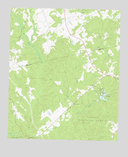
Rock Eagle Lake, GA USGS Topographic Map
Click on map above to begin viewing in our Map Viewer.

This topographic map contains these locations and features:
Feature Name Type Latitude Longitude GNIS ID View Map
Badger CreekStreamN33.3796°W83.4991°347186View Map
Baltimore BranchStreamN33.4168°W83.4310°347187View Map
Bruce LakeReservoirN33.4882°W83.4327°338943View Map
Bruce Lake DamDamN33.4868°W83.4332°338942View Map
Central Georgia Branch Station Wildlife Management AreaParkN33.4126°W83.4541°352301View Map
Central Georgia Experiment StationLocaleN33.4010°W83.4913°347192View Map
Davis LakeReservoirN33.3851°W83.4509°340081View Map
Davis Lake DamDamN33.3851°W83.4499°340080View Map
Dearing Number Six LakeReservoirN33.3768°W83.4199°339532View Map
Dearing Number Six Lake DamDamN33.3768°W83.4199°339531View Map
Eatonton DivisionCivilN33.3775°W83.4299°1936242View Map
Experiment Lake Number OneReservoirN33.3995°W83.4531°344398View Map
Experiment Lake Number One DamDamN33.3985°W83.4516°344397View Map
Georgia Experiment Station DamDamN33.3951°W83.4899°340583View Map
Georgia Experiment Station LakeReservoirN33.3948°W83.4904°340584View Map
Hill DamDamN33.4668°W83.4282°336530View Map
Hill LakeReservoirN33.4678°W83.4287°336531View Map
Little Glady Hunt CampLocaleN33.3860°W83.4132°330627View Map
Little Indian CreekStreamN33.4665°W83.4771°328555View Map
Mithchems School (historical)SchoolN33.4946°W83.4388°346007View Map
Morgan County Fire Rescue Department Station 8BuildingN33.4945°W83.4166°2604538View Map
Moseley Lookout TowerTowerN33.3996°W83.4918°330846View Map
Oconee Work CenterLocaleN33.4126°W83.3802°330845View Map
Presley Mill (historical)LocaleN33.3757°W83.4716°347245View Map
Reids CrossroadsPopulated PlaceN33.4093°W83.4266°329398View Map
Rock Eagle LakeReservoirN33.4175°W83.3923°329463View Map
Rock Eagle Lake DamDamN33.4137°W83.3949°336440View Map
Rock Eagle MonumentParkN33.4174°W83.3885°329464View Map
Sandhill Church (historical)ChurchN33.3962°W83.4032°347259View Map
Shepherd CemeteryCemeteryN33.4748°W83.4527°346024View Map
Springfield Baptist ChurchChurchN33.4963°W83.4190°329799View Map
Springfield Baptist Church CemeteryCemeteryN33.4959°W83.4185°2573990View Map
The Glades (historical)Populated PlaceN33.3946°W83.4438°347262View Map
Thompson DamDamN33.4668°W83.4666°335997View Map
Tirzah Church (historical)ChurchN33.4162°W83.4332°347263View Map
Trinity ChurchChurchN33.4987°W83.4393°346032View Map
Union Chapel ChurchChurchN33.4271°W83.4035°330099View Map
Zachary Chapel (historical)ChurchN33.4365°W83.3910°347273View Map

Note: Coordinates in the location and feature list above are referenced to NAD83 datum.


Copyright (C) 2008-2025 Ryan Niemi / Sunset Dynamics ... All Rights Reserved