TopoQuest Logo
Do you find TopoQuest useful?
Help keep TopoQuest running and adding new maps/features by donating!
Bitcoin:  19c7KJd3qBynnjoSw5npx9KScwjBe4ifkT
Litecoin:  LXs6TkuXGGXo1vDsWCkWVdjQX94eUKd6ui
Home View Maps Find Maps Find Places Resources & Links


Sharon SE, Mississippi Topographic Map

USGS Map Title: Sharon SE, MS
USGS Map MRC: 32089E7
DRG (GeoTIFF) Download: o32089e7.tif


Neighboring USGS Topographic Map Quads:


  Sharon, MS  
32089F8
 

  Farmhaven, MS  
32089F7
 

  Ofahoma, MS  
32089F6
 

  Shoccoe, MS  
32089E8
 

  Sharon SE, MS  
32089E7
 

  Ludlow, MS  
32089E6
 

  Goshen Springs, MS  
32089D8
 

  Leesburg, MS  
32089D7
 

  Forkville, MS  
32089D6


Map MRC Location:

N33°
W90°
N33°
W89°
H8 H7 H6 H5 H4 H3 H2 H1
G8 G7 G6 G5 G4 G3 G2 G1
F8 F7 F6 F5 F4 F3 F2 F1
E8 E7 E6 E5 E4 E3 E2 E1
D8 D7 D6 D5 D4 D3 D2 D1
C8 C7 C6 C5 C4 C3 C2 C1
B8 B7 B6 B5 B4 B3 B2 B1
A8 A7 A6 A5 A4 A3 A2 A1
N32°
W90°
N32°
W89°

Sharon SE, MS USGS 1:24K Topographic Map Preview:
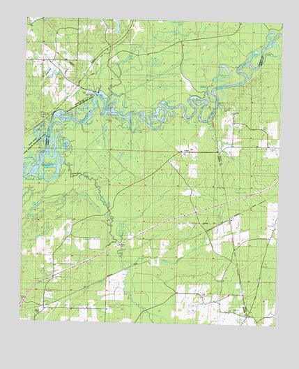
Sharon SE, MS USGS Topographic Map
Click on map above to begin viewing in our Map Viewer.

This topographic map contains these locations and features:
Feature Name Type Latitude Longitude GNIS ID View Map
Adam LakeLakeN32.6089°W89.8259°666146View Map
Allen ChapelChurchN32.5421°W89.7517°666209View Map
Alligator LakeLakeN32.6110°W89.7642°666228View Map
Beach Bluff LakeLakeN32.5915°W89.8073°666621View Map
Black LakeLakeN32.5778°W89.8694°667232View Map
Browns LakeLakeN32.5885°W89.8450°667648View Map
Browns Old RiverStreamN32.5887°W89.8342°667650View Map
Coal Bluff ChurchChurchN32.5862°W89.7726°691115View Map
Coal Bluff ParkParkN32.5882°W89.7798°691114View Map
Coffee BogueStreamN32.6076°W89.7601°692938View Map
Cypress LakeLakeN32.6209°W89.8027°669061View Map
Dancing Rabbit CreekStreamN32.6204°W89.8023°669091View Map
Deer CreekStreamN32.5251°W89.8256°669197View Map
EurekaPopulated PlaceN32.5090°W89.7859°709027View Map
Eureka CemeteryCemeteryN32.5124°W89.7865°709028View Map
Eureka ChurchChurchN32.5121°W89.7865°669824View Map
Eureka School (historical)SchoolN32.5121°W89.7859°709029View Map
Fannegusha CreekStreamN32.5604°W89.8709°693201View Map
Forty (historical)Populated PlaceN32.5185°W89.7765°709051View Map
Gilbert - Williams CemeteryCemeteryN32.5997°W89.8593°2042964View Map
Henry Grady School (historical)SchoolN32.5113°W89.7862°690065View Map
Holmes ChurchChurchN32.5054°W89.7706°691113View Map
Lake CreekStreamN32.5937°W89.8317°672259View Map
Little Adam LakeLakeN32.6069°W89.8294°672527View Map
Lone Pine CemeteryCemeteryN32.5413°W89.7882°709074View Map
Lone Pine ChurchChurchN32.5415°W89.7870°672784View Map
Long LakeLakeN32.6204°W89.7557°672834View Map
Midway CemeteryCemeteryN32.5040°W89.7645°709083View Map
Midway Church (historical)ChurchN32.5038°W89.7645°691150View Map
Miracle TempleChurchN32.5035°W89.8654°691112View Map
Miracle Temple CemeteryCemeteryN32.5054°W89.8640°709086View Map
Miracle Temple Deliverance ChurchChurchN32.5051°W89.8640°709087View Map
Old Iron CemeteryCemeteryN32.6221°W89.8735°2043011View Map
Ophelia (historical)Populated PlaceN32.5590°W89.8167°709105View Map
Pace AirstripAirportN32.6036°W89.8626°2676438View Map
Pete LakeLakeN32.5476°W89.8683°675644View Map
Pine Bluff LakeLakeN32.5813°W89.8249°675798View Map
Purnell CreekStreamN32.5215°W89.8242°676422View Map
RatliffPopulated PlaceN32.5710°W89.7984°711117View Map
Ratliff FerryLocaleN32.5937°W89.8404°691117View Map
Ratliffs Ferry (historical)CrossingN32.5935°W89.8398°686120View Map
Richards Old RiverLakeN32.5949°W89.7855°676628View Map
River Bend Roadside ParkLocaleN32.5851°W89.8617°691116View Map
Rollison CreekStreamN32.5049°W89.8126°676830View Map
Round LakeLakeN32.5879°W89.8101°676906View Map
Sand Hill ChurchChurchN32.5126°W89.8626°691111View Map
Sand Hill School (historical)SchoolN32.5124°W89.8642°691168View Map
Sycamore CreekStreamN32.5832°W89.7851°678509View Map
Tupelo Gum LakeLakeN32.6056°W89.7764°678932View Map
Twin Sisters LakeLakeN32.5726°W89.8551°679009View Map

Note: Coordinates in the location and feature list above are referenced to NAD83 datum.


Copyright (C) 2008-2025 Ryan Niemi / Sunset Dynamics ... All Rights Reserved