TopoQuest Logo
Do you find TopoQuest useful?
Help keep TopoQuest running and adding new maps/features by donating!
Bitcoin:  19c7KJd3qBynnjoSw5npx9KScwjBe4ifkT
Litecoin:  LXs6TkuXGGXo1vDsWCkWVdjQX94eUKd6ui
Home View Maps Find Maps Find Places Resources & Links


Farmhaven, Mississippi Topographic Map

USGS Map Title: Farmhaven, MS
USGS Map MRC: 32089F7
DRG (GeoTIFF) Download: o32089f7.tif


Neighboring USGS Topographic Map Quads:


  Cameron, MS  
32089G8
 

  Camden, MS  
32089G7
 

  Thomastown, MS  
32089G6
 

  Sharon, MS  
32089F8
 

  Farmhaven, MS  
32089F7
 

  Ofahoma, MS  
32089F6
 

  Shoccoe, MS  
32089E8
 

  Sharon SE, MS  
32089E7
 

  Ludlow, MS  
32089E6


Map MRC Location:

N33°
W90°
N33°
W89°
H8 H7 H6 H5 H4 H3 H2 H1
G8 G7 G6 G5 G4 G3 G2 G1
F8 F7 F6 F5 F4 F3 F2 F1
E8 E7 E6 E5 E4 E3 E2 E1
D8 D7 D6 D5 D4 D3 D2 D1
C8 C7 C6 C5 C4 C3 C2 C1
B8 B7 B6 B5 B4 B3 B2 B1
A8 A7 A6 A5 A4 A3 A2 A1
N32°
W90°
N32°
W89°

Farmhaven, MS USGS 1:24K Topographic Map Preview:
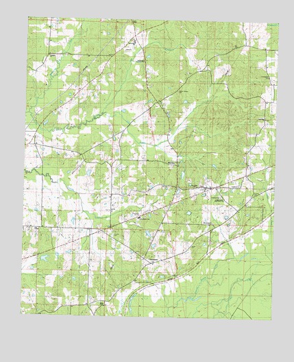
Farmhaven, MS USGS Topographic Map
Click on map above to begin viewing in our Map Viewer.

This topographic map contains these locations and features:
Feature Name Type Latitude Longitude GNIS ID View Map
Bennett Lake DamDamN32.6501°W89.8684°681560View Map
Brown CemeteryCemeteryN32.6805°W89.7856°2042943View Map
Camp Ground CemeteryCemeteryN32.7021°W89.8700°2042948View Map
Choctaw Boundary Historical SiteParkN32.6432°W89.7973°711343View Map
Clarks ChapelChurchN32.7490°W89.8229°668519View Map
Collin Wohner Lake DamDamN32.7035°W89.8651°681589View Map
Crossroads ChurchChurchN32.6760°W89.7770°691082View Map
Doaks Field (historical)LocaleN32.7001°W89.8245°683234View Map
Doaks Mill (historical)LocaleN32.7121°W89.8367°683235View Map
Doaks Stand (historical)LocaleN32.7126°W89.8159°683236View Map
Doaks Stand Post Office (historical)Post OfficeN32.6579°W89.8101°712160View Map
Eugene Garrett Memorial Garden CemeteryCemeteryN32.6760°W89.7765°691083View Map
FarmhavenPopulated PlaceN32.6476°W89.8106°669914View Map
Farmhaven ChurchChurchN32.6810°W89.7670°691151View Map
Farmhaven Church CemeteryCemeteryN32.6813°W89.7670°2042960View Map
Farmhaven Fire StationBuildingN32.6674°W89.8176°691089View Map
Farmhaven School (historical)SchoolN32.6660°W89.7765°691142View Map
Faucette CemeteryCemeteryN32.6771°W89.7606°669924View Map
Full Gospel ChurchChurchN32.6801°W89.7890°691084View Map
HavendalePopulated PlaceN32.6965°W89.8709°683242View Map
Hayes CemeteryCemeteryN32.6552°W89.7909°671024View Map
Immaculate Conception ChurchChurchN32.7329°W89.8162°671653View Map
Kentuctah CreekStreamN32.7101°W89.8726°672109View Map
L L Bennett Pond DamDamN32.6501°W89.8517°681559View Map
Lee ChapelChurchN32.6615°W89.8684°672378View Map
Liberty ChurchChurchN32.7376°W89.8256°672450View Map
Liberty Church CemeteryCemeteryN32.7373°W89.8256°2042990View Map
Lott CemeteryCemeteryN32.7376°W89.8286°2042993View Map
Lott CreekStreamN32.7101°W89.8362°672889View Map
Lottville CemeteryCemeteryN32.6595°W89.8297°672893View Map
Lottville ChurchChurchN32.6699°W89.8315°672894View Map
Luckett CreekStreamN32.6524°W89.7517°672946View Map
Luther Branson Elementary SchoolSchoolN32.6669°W89.8171°691081View Map
Madison County Lake DamDamN32.7151°W89.7934°681597View Map
MillvillePopulated PlaceN32.6710°W89.7687°705853View Map
Mount Pilgrim ChurchChurchN32.7346°W89.8634°674190View Map
New Truelight ChurchChurchN32.6801°W89.7851°674857View Map
Old Sulphur Springs Catholic CemeteryCemeteryN32.7281°W89.7947°2043013View Map
Old Truelight ChurchChurchN32.6654°W89.7806°691170View Map
RaytownPopulated PlaceN32.6893°W89.7987°676507View Map
Raytown CemeteryCemeteryN32.6818°W89.7979°2043025View Map
Rising Star ChapelChurchN32.6299°W89.8337°691087View Map
Rising Star School (historical)SchoolN32.6287°W89.8334°691163View Map
Sacred Heart SchoolChurchN32.7401°W89.8201°691165View Map
Saint Elizabeth CemeteryCemeteryN32.6668°W89.7542°691080View Map
Saint Elizabeth School (historical)SchoolN32.7279°W89.7537°691166View Map
Sulpher Springs (historical)LocaleN32.7232°W89.7973°692357View Map
Sulphur Springs Methodist CemeteryCemeteryN32.7201°W89.7999°691085View Map
Truelight Mission Baptist CemeteryCemeteryN32.6802°W89.7855°2043054View Map
Virgin Mary CemeteryCemeteryN32.7093°W89.7555°2043060View Map
Virgin Mary ChurchChurchN32.7090°W89.7554°679227View Map
Yockanookany Roadside ParkParkN32.6618°W89.7640°691088View Map

Note: Coordinates in the location and feature list above are referenced to NAD83 datum.


Copyright (C) 2008-2025 Ryan Niemi / Sunset Dynamics ... All Rights Reserved