TopoQuest Logo
Do you find TopoQuest useful?
Help keep TopoQuest running and adding new maps/features by donating!
Bitcoin:  19c7KJd3qBynnjoSw5npx9KScwjBe4ifkT
Litecoin:  LXs6TkuXGGXo1vDsWCkWVdjQX94eUKd6ui
Home View Maps Find Maps Find Places Resources & Links


Sheldon, Iowa Topographic Map

USGS Map Title: Sheldon, IA
USGS Map MRC: 43095B7
DRG (GeoTIFF) Download: o43095b7.tif


Neighboring USGS Topographic Map Quads:


  George East, IA  
43095C8
 

  Ashton, IA  
43095C7
 

  Cloverdale, IA  
43095C6
 

  Matlock, IA  
43095B8
 

  Sheldon, IA  
43095B7
 

  Sanborn, IA  
43095B6
 

  Hospers, IA  
43095A8
 

  Sheldon SE, IA  
43095A7
 

  Primghar, IA  
43095A6


Map MRC Location:

N44°
W96°
N44°
W95°
H8 H7 H6 H5 H4 H3 H2 H1
G8 G7 G6 G5 G4 G3 G2 G1
F8 F7 F6 F5 F4 F3 F2 F1
E8 E7 E6 E5 E4 E3 E2 E1
D8 D7 D6 D5 D4 D3 D2 D1
C8 C7 C6 C5 C4 C3 C2 C1
B8 B7 B6 B5 B4 B3 B2 B1
A8 A7 A6 A5 A4 A3 A2 A1
N43°
W96°
N43°
W95°

Sheldon, IA USGS 1:24K Topographic Map Preview:
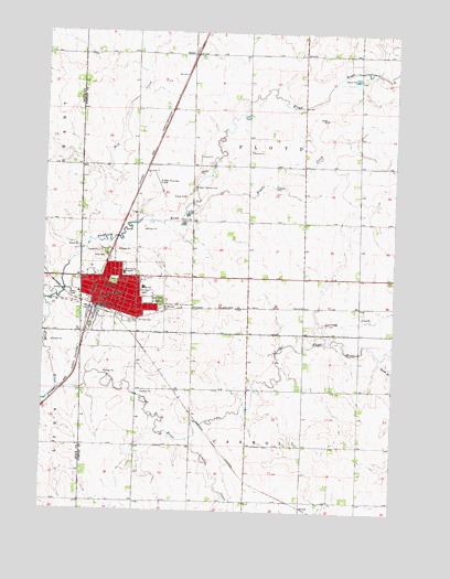
Sheldon, IA USGS Topographic Map
Click on map above to begin viewing in our Map Viewer.

This topographic map contains these locations and features:
Feature Name Type Latitude Longitude GNIS ID View Map
Bethel Reformed ChurchChurchN43.1819°W95.8495°1907022View Map
Calvary Baptist ChurchChurchN43.1780°W95.8472°1907026View Map
Christian Retirement HomeHospitalN43.1803°W95.8414°1907012View Map
City of SheldonCivilN43.1796°W95.8441°2395868View Map
Cottonwood FarmLocaleN43.1556°W95.8228°2712769View Map
D G FarmsLocaleN43.1697°W95.8622°2722831View Map
East Elementary SchoolSchoolN43.1833°W95.8399°456199View Map
East Lawn CemeteryCemeteryN43.1799°W95.8340°456168View Map
Engels CreekStreamN43.2055°W95.8225°456376View Map
EvanderPopulated PlaceN43.1786°W95.7625°464064View Map
First Christian Reformed ChurchChurchN43.1791°W95.8461°1907029View Map
First Reformed ChurchChurchN43.1808°W95.8422°1907023View Map
Hengeveld FarmLocaleN43.1722°W95.8733°2722828View Map
Hills ParkParkN43.1922°W95.8534°457500View Map
Honoring World War I Veterans Historical MarkerParkN43.1847°W95.8503°1907038View Map
Immanuel Christian Reformed ChurchChurchN43.1819°W95.8358°1907030View Map
Iowa State Residential Treatment CenterBuildingN43.1846°W95.8624°2333480View Map
Kay - Kel - Sha FarmLocaleN43.1847°W95.7603°2722844View Map
KIWA-AM (Sheldon)TowerN43.1833°W95.8684°467287View Map
KIWA-FM (Sheldon)TowerN43.1822°W95.8684°463727View Map
KIWA-FM (Sheldon)TowerN43.1833°W95.8684°467344View Map
Lamkin CreekStreamN43.1436°W95.8231°458213View Map
Little Floyd RiverStreamN43.1566°W95.8697°458467View Map
Memorial to Four Pioneers Historical MarkerParkN43.1722°W95.7508°1907006View Map
Miedema Chiropractic ClinicHospitalN43.1805°W95.8531°1907019View Map
Northwest Iowa Health CenterHospitalN43.1869°W95.8464°1907015View Map
Northwest Iowa Urologists CenterHospitalN43.1811°W95.8561°1907020View Map
Oak Park Care CenterHospitalN43.1869°W95.8464°1907014View Map
Parkview Assembly ChurchChurchN43.1847°W95.8522°1907028View Map
Pellerin Chiropractic ClinicHospitalN43.1855°W95.8447°1907016View Map
RitterPopulated PlaceN43.2441°W95.8228°464720View Map
Ruby Chiropractic ClinicHospitalN43.1825°W95.8533°1907017View Map
Ruby Chiropractic ClinicHospitalN43.1819°W95.8342°1907018View Map
Saint Patrick's Catholic SchoolSchoolN43.1789°W95.8546°461269View Map
Saint Patricks CemeteryCemeteryN43.1779°W95.8325°461257View Map
Saint Patricks ChurchChurchN43.1791°W95.8545°1907025View Map
Saint Paul CemeteryCemeteryN43.1746°W95.8413°461275View Map
Saint Paul Lutheran ChurchChurchN43.1775°W95.8406°1907031View Map
Sanford Sheldon Medical CenterHospitalN43.1871°W95.8467°2552137View Map
SheldonLocaleN43.1778°W95.8553°1907011View Map
SheldonPopulated PlaceN43.1811°W95.8561°461558View Map
Sheldon Branch Church of Latter Day SaintsChurchN43.1869°W95.8531°1907027View Map
Sheldon Chiropractic ClinicHospitalN43.1811°W95.8561°1907021View Map
Sheldon Christian SchoolSchoolN43.1791°W95.8409°1907033View Map
Sheldon City HallBuildingN43.1800°W95.8531°463808View Map
Sheldon City ParkParkN43.1847°W95.8503°1907039View Map
Sheldon Community Ambulance TeamBuildingN43.1801°W95.8529°2599648View Map
Sheldon Country ClubLocaleN43.2094°W95.8222°465898View Map
Sheldon Family Practice AssociationHospitalN43.1869°W95.8464°1907013View Map
Sheldon Fire DepartmentBuildingN43.1801°W95.8529°1907035View Map
Sheldon High SchoolSchoolN43.1844°W95.8351°1907143View Map
Sheldon Middle SchoolSchoolN43.1837°W95.8287°1907032View Map
Sheldon Police DepartmentBuildingN43.1801°W95.8529°1907034View Map
Sheldon Post OfficePost OfficeN43.1786°W95.8556°1907010View Map
Sheldon Prairie MuseumBuildingN43.1800°W95.8545°1907007View Map
Sheldon Public LibraryBuildingN43.1797°W95.8536°1907008View Map
Sheldon Regional AirportAirportN43.2084°W95.8334°467238View Map
Siouxland Farmers Co-op ElevatorLocaleN43.1864°W95.8433°1907009View Map
South Branch Little Floyd RiverStreamN43.1655°W95.7547°461765View Map
Sunrise ParkParkN43.1889°W95.8336°1907037View Map
Sweeney CreekStreamN43.1691°W95.7786°462149View Map
Thorman ParkParkN43.1728°W95.8433°1907036View Map
Township of CarrollCivilN43.1278°W95.8017°467533View Map
Township of FloydCivilN43.2146°W95.8026°467838View Map
United Methodist ChurchChurchN43.1811°W95.8517°1907024View Map
Wolf CreekStreamN43.1958°W95.8589°463157View Map

Note: Coordinates in the location and feature list above are referenced to NAD83 datum.


Copyright (C) 2008-2025 Ryan Niemi / Sunset Dynamics ... All Rights Reserved