TopoQuest Logo
Do you find TopoQuest useful?
Help keep TopoQuest running and adding new maps/features by donating!
Bitcoin:  19c7KJd3qBynnjoSw5npx9KScwjBe4ifkT
Litecoin:  LXs6TkuXGGXo1vDsWCkWVdjQX94eUKd6ui
Home View Maps Find Maps Find Places Resources & Links


Sheldon Springs, Vermont Topographic Map

USGS Map Title: Sheldon Springs, VT
USGS Map MRC: 44072H8
DRG (GeoTIFF) Download: o44072h8.tif


Neighboring USGS Topographic Map Quads:


  Highgate Center, VT  
44073H1
 

  Sheldon Springs, VT  
44072H8
 

  Enosburg Falls, VT  
44072H7
 

  Saint Albans, VT  
44073G1
 

  Fairfield, VT  
44072G8
 

  Bakersfield, VT  
44072G7


Map MRC Location:

N45°
W73°
N45°
W72°
H8 H7 H6 H5 H4 H3 H2 H1
G8 G7 G6 G5 G4 G3 G2 G1
F8 F7 F6 F5 F4 F3 F2 F1
E8 E7 E6 E5 E4 E3 E2 E1
D8 D7 D6 D5 D4 D3 D2 D1
C8 C7 C6 C5 C4 C3 C2 C1
B8 B7 B6 B5 B4 B3 B2 B1
A8 A7 A6 A5 A4 A3 A2 A1
N44°
W73°
N44°
W72°

Sheldon Springs, VT USGS 1:24K Topographic Map Preview:
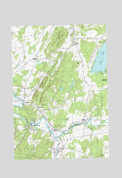
Sheldon Springs, VT USGS Topographic Map
Click on map above to begin viewing in our Map Viewer.

This topographic map contains these locations and features:
Feature Name Type Latitude Longitude GNIS ID View Map
Black CreekStreamN44.8950°W72.9446°1456441View Map
Bridgeman HillSummitN44.9892°W72.9365°1456563View Map
Browns CornersPopulated PlaceN44.9684°W72.9687°1456608View Map
Bullis PondReservoirN44.9657°W72.9654°1766660View Map
Bullis Pond DamDamN44.9684°W72.9662°1766659View Map
Camp GroundsPopulated PlaceN44.9089°W72.8835°1456730View Map
Culler - Cutler CemeteryCemeteryN44.9356°W72.9945°1920564View Map
East HighgatePopulated PlaceN44.9273°W72.9879°1457283View Map
East Highgate CemeteryCemeteryN44.9351°W72.9775°1457284View Map
Forest Hill School (historical)SchoolN44.9370°W72.9371°1920613View Map
FranklinPopulated PlaceN44.9820°W72.9162°1457488View Map
Franklin Central SchoolSchoolN44.9843°W72.9201°1920615View Map
Franklin Fire and RescueBuildingN44.9814°W72.9151°2121451View Map
Franklin Post OfficePost OfficeN44.9814°W72.9162°1920618View Map
Gallop CemeteryCemeteryN44.9105°W72.8905°1920621View Map
Gates HillSummitN44.9639°W72.9168°1457527View Map
Grace CemeteryCemeteryN44.8852°W72.9402°1920629View Map
Grace ChurchChurchN44.8850°W72.9399°1920630View Map
Haston LibraryBuildingN44.9812°W72.9176°1920635View Map
Hyde CemeteryCemeteryN44.9303°W72.9976°1457953View Map
Lake CarmiReservoirN44.9723°W72.8755°1456770View Map
Maple Grove CemeteryCemeteryN44.9883°W72.9178°1920682View Map
Maple Grove CemeteryCemeteryN44.9883°W72.9178°1458347View Map
McGowan BrookStreamN44.9067°W72.9560°1458393View Map
Morrow BrookStreamN44.9067°W72.9071°1458548View Map
New Protestant CemeteryCemeteryN44.9820°W72.9188°1920704View Map
New Testament Christian AcademySchoolN44.9643°W72.9817°2427461View Map
North SheldonPopulated PlaceN44.9106°W72.9071°1458759View Map
North Sheldon - Fish CemeteryCemeteryN44.9088°W72.9040°1920708View Map
Patten CampLocaleN44.9839°W72.8765°1920716View Map
Patton CemeteryCemeteryN44.9875°W72.8799°1920717View Map
Patton CemeteryCemeteryN44.9893°W72.8775°1458905View Map
Pomeroy School (historical)SchoolN44.9528°W72.9051°1920719View Map
Rice HillSummitN44.9328°W72.9612°1459173View Map
Rice Hill School (historical)SchoolN44.9223°W72.9501°1920725View Map
Saint Anthonys CemeteryCemeteryN44.9058°W72.9820°1920752View Map
Saint Marys CemeteryCemeteryN44.9828°W72.9191°1920762View Map
ShawvillePopulated PlaceN44.9198°W72.9657°1459470View Map
SheldonPopulated PlaceN44.8817°W72.9429°1459481View Map
Sheldon CemeteryCemeteryN44.8863°W72.9491°1920774View Map
Sheldon Elementary SchoolSchoolN44.9006°W72.9695°1920775View Map
Sheldon Fire StationBuildingN44.9057°W72.9758°2121503View Map
Sheldon HillSummitN44.8759°W72.8885°1459484View Map
Sheldon Home Association CemeteryCemeteryN44.8928°W72.9645°1920776View Map
Sheldon JunctionPopulated PlaceN44.9017°W72.9476°1459485View Map
Sheldon Post OfficePost OfficeN44.8820°W72.9464°1920777View Map
Sheldon SpringsPopulated PlaceN44.9062°W72.9776°1459486View Map
Sheldon Springs DamDamN44.9117°W72.9746°1766561View Map
Sheldon Springs Post OfficePost OfficeN44.9040°W72.9744°2759989View Map
Sheldon Union CemeteryCemeteryN44.9204°W72.9630°1920779View Map
Town of FranklinCivilN44.9763°W72.8978°1462100View Map
Town of SheldonCivilN44.8990°W72.9213°1462207View Map
Union CemeteryCemeteryN44.9209°W72.9637°1459988View Map
Willard CemeteryCemeteryN44.9927°W72.9483°1920814View Map

Note: Coordinates in the location and feature list above are referenced to NAD83 datum.


Copyright (C) 2008-2024 Ryan Niemi / Sunset Dynamics ... All Rights Reserved