TopoQuest Logo
Do you find TopoQuest useful?
Help keep TopoQuest running and adding new maps/features by donating!
Bitcoin:  19c7KJd3qBynnjoSw5npx9KScwjBe4ifkT
Litecoin:  LXs6TkuXGGXo1vDsWCkWVdjQX94eUKd6ui
Home View Maps Find Maps Find Places Resources & Links


Shelly Baldy Peak, Utah Topographic Map

USGS Map Title: Shelly Baldy Peak, UT
USGS Map MRC: 38112C4
DRG (GeoTIFF) Download: o38112c4.tif


Neighboring USGS Topographic Map Quads:


  Pole Mountain, UT  
38112D5
 

  Mount Belknap, UT  
38112D4
 

  Mount Brigham, UT  
38112D3
 

  Black Ridge, UT  
38112C5
 

  Shelly Baldy Peak, UT  
38112C4
 

  Delano Peak, UT  
38112C3
 

  Kane Canyon, UT  
38112B5
 

  Circleville Mountain, UT  
38112B4
 

  Circleville, UT  
38112B3


Map MRC Location:

N39°
W113°
N39°
W112°
H8 H7 H6 H5 H4 H3 H2 H1
G8 G7 G6 G5 G4 G3 G2 G1
F8 F7 F6 F5 F4 F3 F2 F1
E8 E7 E6 E5 E4 E3 E2 E1
D8 D7 D6 D5 D4 D3 D2 D1
C8 C7 C6 C5 C4 C3 C2 C1
B8 B7 B6 B5 B4 B3 B2 B1
A8 A7 A6 A5 A4 A3 A2 A1
N38°
W113°
N38°
W112°

Shelly Baldy Peak, UT USGS 1:24K Topographic Map Preview:
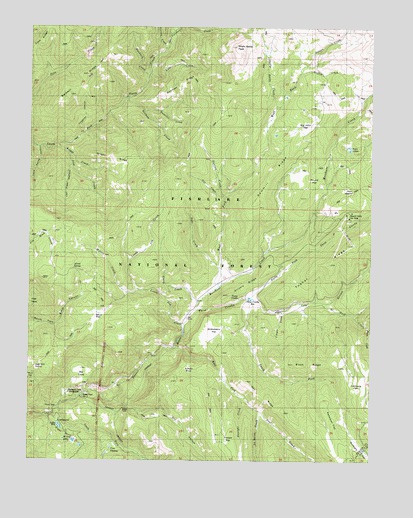
Shelly Baldy Peak, UT USGS Topographic Map
Click on map above to begin viewing in our Map Viewer.

This topographic map contains these locations and features:
Feature Name Type Latitude Longitude GNIS ID View Map
Allred SpringSpringN38.3049°W112.4846°1438169View Map
Baldwin RidgeRidgeN38.3600°W112.4813°1438364View Map
Beetle CreekStreamN38.2883°W112.3760°1438570View Map
Big CoveBasinN38.2772°W112.4794°1438649View Map
Big John FlatFlatN38.3497°W112.4008°1438695View Map
Bosman CreekStreamN38.3550°W112.4649°1439013View Map
Bosman RidgeRidgeN38.3583°W112.4463°1439014View Map
Briggs CreekStreamN38.3383°W112.4869°1439105View Map
Briggs RidgeRidgeN38.3372°W112.4727°1439108View Map
Britts MeadowsFlatN38.2944°W112.4022°1438060View Map
Buck RidgeRidgeN38.2786°W112.3935°1439233View Map
Copes BasinBasinN38.2536°W112.4941°1439939View Map
Cougar CreekStreamN38.2933°W112.4085°1440054View Map
Crazy CreekStreamN38.2955°W112.4385°1440140View Map
Cys CacheLakeN38.2537°W112.4705°1440222View Map
Deer CreekStreamN38.3053°W112.4308°1440365View Map
Delano Ranger StationLocaleN38.2922°W112.3999°1448339View Map
Dry HollowValleyN38.2675°W112.4694°1440652View Map
Duncan CreekStreamN38.3266°W112.4294°1440715View Map
Forked FlatFlatN38.2544°W112.4260°1441171View Map
Gill CreekStreamN38.3266°W112.4294°1441322View Map
Gorrilla CreekStreamN38.3680°W112.4516°1441386View Map
Griffith CreekStreamN38.3619°W112.4022°1448447View Map
Grizzly RidgesRidgeN38.3055°W112.4124°1441512View Map
Gunsight FlatFlatN38.2575°W112.3833°1441530View Map
Harmony ParkFlatN38.2753°W112.3769°1441605View Map
Hi Hunt CreekStreamN38.2955°W112.3933°1450383View Map
Hi Low LakeLakeN38.2542°W112.4816°1441728View Map
Hy Hunt CreekStreamN38.2955°W112.3930°1441961View Map
Iant CreekStreamN38.2633°W112.4163°1441975View Map
Iant RidgeRidgeN38.2703°W112.4138°1428958View Map
Iron CreekStreamN38.3411°W112.4910°1442047View Map
Kays MeadowFlatN38.3255°W112.3833°1442284View Map
Lake StreamStreamN38.2966°W112.4199°1442422View Map
LeBaron CreekStreamN38.2633°W112.4163°1442383View Map
Lion CreekStreamN38.3614°W112.4572°1442642View Map
Little ReservoirReservoirN38.2599°W112.4893°1442772View Map
Little Reservoir CampgroundLocaleN38.2611°W112.4894°1451283View Map
Little Reservoir DamDamN38.2605°W112.4902°1447683View Map
Lousy Jim CreekStreamN38.2894°W112.4438°1442987View Map
Mahogany Cove CampgroundLocaleN38.2694°W112.4858°1448635View Map
Manhard CreekStreamN38.3605°W112.4574°1443125View Map
Merchant CreekStreamN38.2822°W112.4472°1443306View Map
Mount Holly Fire StatioinBuildingN38.3222°W112.3833°2768467View Map
Mount Holly Ski AreaLocaleN38.3205°W112.3841°1448695View Map
Mud FlatFlatN38.2905°W112.4760°1443663View Map
North Fork Three CreeksStreamN38.2966°W112.4199°1443941View Map
Peterson FlatFlatN38.2550°W112.3899°1444306View Map
Poison CreekStreamN38.3519°W112.4105°1444502View Map
Power Plant Number 2BuildingN38.2683°W112.4808°1454576View Map
Robbers RoostLocaleN38.2794°W112.4422°1445016View Map
Round FlatFlatN38.3283°W112.4008°1445160View Map
Sage Hill SpringSpringN38.2774°W112.4981°1448951View Map
Sawmill ForkStreamN38.3103°W112.4133°1448976View Map
Sawmill RidgeRidgeN38.3253°W112.4174°1445356View Map
Shelly Baldy CreekStreamN38.3519°W112.4105°1445517View Map
Shelly Baldy PeakSummitN38.3691°W112.4255°1445518View Map
South Fork Beaver RiverStreamN38.2650°W112.4899°1445825View Map
South Fork Three CreeksStreamN38.2966°W112.4199°1445882View Map
Straight CreekStreamN38.2680°W112.4213°1446173View Map
Strawberry FlatFlatN38.2866°W112.4324°1446182View Map
Sweetwater CreekStreamN38.3750°W112.4463°1446294View Map
Third Spring HollowValleyN38.3402°W112.4974°1446528View Map
Three CreeksStreamN38.2933°W112.4397°1446557View Map
Three Creeks DamDamN38.2950°W112.4224°1447697View Map
Three Creeks ReservoirReservoirN38.2964°W112.4187°1447696View Map
Tungsten HollowValleyN38.3439°W112.4824°1446760View Map
Tushar MountainsRangeN38.3703°W112.3816°1446768View Map
Tushar RidgeRidgeN38.3097°W112.3883°1446769View Map
Twin LakesLakeN38.3398°W112.3838°1446788View Map
Van Fleet HollowValleyN38.3352°W112.4858°1446913View Map
Waterfull CreekStreamN38.3502°W112.4591°1447073View Map
West Fork Merchant CreekStreamN38.3003°W112.4316°1447149View Map
Wilson CreekStreamN38.2989°W112.4605°1447454View Map

Note: Coordinates in the location and feature list above are referenced to NAD83 datum.


Copyright (C) 2008-2025 Ryan Niemi / Sunset Dynamics ... All Rights Reserved