TopoQuest Logo
Do you find TopoQuest useful?
Help keep TopoQuest running and adding new maps/features by donating!
Bitcoin:  19c7KJd3qBynnjoSw5npx9KScwjBe4ifkT
Litecoin:  LXs6TkuXGGXo1vDsWCkWVdjQX94eUKd6ui
Home View Maps Find Maps Find Places Resources & Links


Black Ridge, Utah Topographic Map

USGS Map Title: Black Ridge, UT
USGS Map MRC: 38112C5
DRG (GeoTIFF) Download: o38112c5.tif


Neighboring USGS Topographic Map Quads:


  Gillies Hill, UT  
38112D6
 

  Pole Mountain, UT  
38112D5
 

  Mount Belknap, UT  
38112D4
 

  Beaver, UT  
38112C6
 

  Black Ridge, UT  
38112C5
 

  Shelly Baldy Peak, UT  
38112C4
 

  Greenville Bench, UT  
38112B6
 

  Kane Canyon, UT  
38112B5
 

  Circleville Mountain, UT  
38112B4


Map MRC Location:

N39°
W113°
N39°
W112°
H8 H7 H6 H5 H4 H3 H2 H1
G8 G7 G6 G5 G4 G3 G2 G1
F8 F7 F6 F5 F4 F3 F2 F1
E8 E7 E6 E5 E4 E3 E2 E1
D8 D7 D6 D5 D4 D3 D2 D1
C8 C7 C6 C5 C4 C3 C2 C1
B8 B7 B6 B5 B4 B3 B2 B1
A8 A7 A6 A5 A4 A3 A2 A1
N38°
W113°
N38°
W112°

Black Ridge, UT USGS 1:24K Topographic Map Preview:
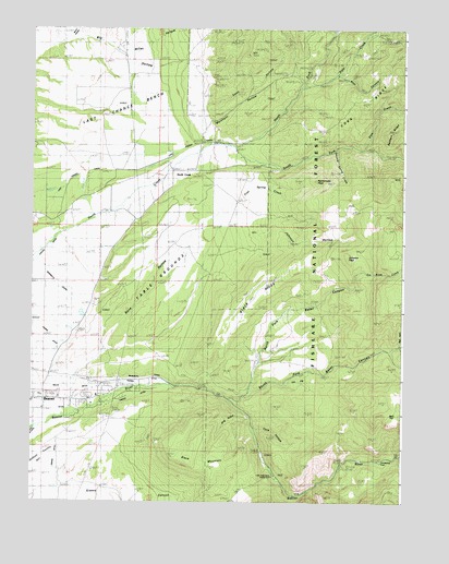
Black Ridge, UT USGS Topographic Map
Click on map above to begin viewing in our Map Viewer.

This topographic map contains these locations and features:
Feature Name Type Latitude Longitude GNIS ID View Map
Bear CanyonValleyN38.3622°W112.5202°1438440View Map
Beaver DivisionCivilN38.3404°W112.5861°1939347View Map
Beaver Municide Power PlantLocaleN38.2636°W112.5477°1454392View Map
Big HollowValleyN38.3669°W112.6249°1438678View Map
Black MountainSummitN38.2633°W112.5738°1438856View Map
Black RidgeRidgeN38.3050°W112.5497°1438871View Map
Bone HollowValleyN38.2905°W112.6019°1438995View Map
Burnt HollowValleyN38.3727°W112.6122°1439359View Map
Cave HollowValleyN38.2697°W112.5491°1439545View Map
Cork RidgeRidgeN38.3675°W112.5022°1439953View Map
Drag HollowValleyN38.2730°W112.5558°1440543View Map
East Fork Baker CanyonValleyN38.2780°W112.5535°1440782View Map
First Spring CreekStreamN38.2839°W112.6102°1441062View Map
Fort Cameron (historical)MilitaryN38.2744°W112.6061°1451125View Map
Grassy CanyonValleyN38.2522°W112.6033°1441438View Map
Harris DitchCanalN38.2833°W112.6124°1441611View Map
Jim Reed CreekStreamN38.2769°W112.5588°1442141View Map
Johnson HollowValleyN38.3236°W112.5444°1442184View Map
Johnson PeakSummitN38.3147°W112.5194°1442190View Map
Last Chance BenchBenchN38.3511°W112.6102°1442447View Map
Last Chance CanalCanalN38.3391°W112.5955°1442448View Map
Lion FlatFlatN38.2819°W112.5363°1442643View Map
Little Cottonwood CampgroundLocaleN38.2569°W112.5438°1454624View Map
Lower Power PlantLocaleN38.2608°W112.5202°1454471View Map
Mammoth CanalCanalN38.2825°W112.5927°1443112View Map
Merchant HollowValleyN38.3514°W112.5635°1443307View Map
Miller HollowValleyN38.3689°W112.5941°1443488View Map
North CreekPopulated PlaceN38.3372°W112.5780°1443869View Map
North Creek Recreation SiteParkN38.3439°W112.5569°1448742View Map
North Fork Baker CanyonValleyN38.2775°W112.5580°1443886View Map
North Fork North CreekStreamN38.3436°W112.5577°1443921View Map
Owens DitchCanalN38.2589°W112.6169°1444132View Map
Pine CreekStreamN38.3433°W112.5141°1444379View Map
Pole CreekStreamN38.3597°W112.5355°1444543View Map
Ponderosa ParkLocaleN38.2619°W112.5052°1454608View Map
Rattlesnake PeakSummitN38.3344°W112.5355°1444741View Map
Second Spring CreekStreamN38.3430°W112.5235°1448984View Map
Skull FlatFlatN38.2741°W112.5033°1445640View Map
South Field DitchCanalN38.3200°W112.6230°1451161View Map
South Fork Baker CanyonValleyN38.2900°W112.5047°1449029View Map
South Fork North CreekStreamN38.3436°W112.5577°1445859View Map
Sway HollowValleyN38.3552°W112.5644°1446283View Map
Table GroundsFlatN38.3119°W112.5774°1446314View Map
United Beaver CamperlandParkN38.2777°W112.6161°1449123View Map
Willis DitchCanalN38.2791°W112.6133°1447387View Map

Note: Coordinates in the location and feature list above are referenced to NAD83 datum.


Copyright (C) 2008-2024 Ryan Niemi / Sunset Dynamics ... All Rights Reserved