TopoQuest Logo
Do you find TopoQuest useful?
Help keep TopoQuest running and adding new maps/features by donating!
Bitcoin:  19c7KJd3qBynnjoSw5npx9KScwjBe4ifkT
Litecoin:  LXs6TkuXGGXo1vDsWCkWVdjQX94eUKd6ui
Home View Maps Find Maps Find Places Resources & Links


Shongaloo, Louisiana Topographic Map

USGS Map Title: Shongaloo, LA
USGS Map MRC: 32093H3
DRG (GeoTIFF) Download: o32093h3.tif


Neighboring USGS Topographic Map Quads:


  Taylor, AR  
33093A4
 

  Walkerville, AR  
33093A3
 

  Emerson, AR  
33093A2
 

  Cullen, LA  
32093H4
 

  Shongaloo, LA  
32093H3
 

  Haynesville West, LA  
32093H2
 

  Cotton Valley, LA  
32093G4
 

  Leton, LA  
32093G3
 

  Blackburn, LA  
32093G2


Map MRC Location:

N33°
W94°
N33°
W93°
H8 H7 H6 H5 H4 H3 H2 H1
G8 G7 G6 G5 G4 G3 G2 G1
F8 F7 F6 F5 F4 F3 F2 F1
E8 E7 E6 E5 E4 E3 E2 E1
D8 D7 D6 D5 D4 D3 D2 D1
C8 C7 C6 C5 C4 C3 C2 C1
B8 B7 B6 B5 B4 B3 B2 B1
A8 A7 A6 A5 A4 A3 A2 A1
N32°
W94°
N32°
W93°

Shongaloo, LA USGS 1:24K Topographic Map Preview:
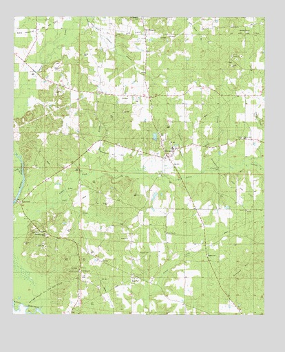
Shongaloo, LA USGS Topographic Map
Click on map above to begin viewing in our Map Viewer.

This topographic map contains these locations and features:
Feature Name Type Latitude Longitude GNIS ID View Map
Duncan HillSummitN32.8946°W93.2577°543155View Map
Dykesville Oil and Gas FieldOilfieldN32.9293°W93.2657°554306View Map
Elizabeth ChurchChurchN32.9013°W93.3082°540886View Map
Hall BranchStreamN32.9340°W93.3366°535491View Map
Haynes CemeteryCemeteryN32.9843°W93.3410°535580View Map
Hicks BranchStreamN32.9360°W93.2829°535657View Map
Hudson CemeteryCemeteryN32.9001°W93.2788°535846View Map
Lick CreekStreamN32.9338°W93.3716°536442View Map
Little Indian CreekStreamN32.9379°W93.2618°536563View Map
Matthews School (historical)SchoolN32.9968°W93.2554°544480View Map
Old Shongallo CemeteryCemeteryN32.9999°W93.3121°540888View Map
Old ShongalooPopulated PlaceN32.9918°W93.3102°537858View Map
Pilgrims Rest CemeteryCemeteryN32.9493°W93.2610°540887View Map
Potter Church (historical)ChurchN32.9693°W93.2516°544479View Map
Potter School (historical)SchoolN32.9618°W93.2674°544478View Map
Red Rock Oil and Gas FieldOilfieldN32.9960°W93.3085°555772View Map
Rhone SchoolSchoolN32.9057°W93.2813°538574View Map
Saints Rest ChurchChurchN32.9954°W93.2677°539089View Map
Salem ChurchChurchN32.9190°W93.2602°539095View Map
Sexton ChurchChurchN32.9493°W93.2613°539265View Map
ShongalooPopulated PlaceN32.9415°W93.2988°543666View Map
Shongaloo High SchoolSchoolN32.9449°W93.2958°544477View Map
Shongaloo Lookout TowerTowerN32.9082°W93.3588°558824View Map
Shongaloo Oil and Gas FieldOilfieldN32.9432°W93.3218°556030View Map
Shongaloo Post OfficePost OfficeN32.9413°W93.2985°1631211View Map
Shongaloo Volunteer Fire DepartmentBuildingN32.9991°W93.3108°2673004View Map
Sweet Home ChurchChurchN32.9096°W93.2991°539759View Map
Sykes FerryLocaleN32.9221°W93.3724°556195View Map
Sykes Ferry Church (historical)ChurchN32.9321°W93.3579°544475View Map
Thorny BranchStreamN32.9343°W93.3029°539901View Map
Tony School (historical)SchoolN32.9682°W93.3332°544476View Map
Union Springs ChurchChurchN32.8935°W93.3432°540109View Map
Union Springs School (historical)SchoolN32.8960°W93.3418°544474View Map
Village of ShongalooCivilN32.9416°W93.2955°2407544View Map
White Rose ChurchChurchN32.9560°W93.3088°540374View Map

Note: Coordinates in the location and feature list above are referenced to NAD83 datum.


Copyright (C) 2008-2025 Ryan Niemi / Sunset Dynamics ... All Rights Reserved