TopoQuest Logo
Do you find TopoQuest useful?
Help keep TopoQuest running and adding new maps/features by donating!
Bitcoin:  19c7KJd3qBynnjoSw5npx9KScwjBe4ifkT
Litecoin:  LXs6TkuXGGXo1vDsWCkWVdjQX94eUKd6ui
Home View Maps Find Maps Find Places Resources & Links


Shopville, Kentucky Topographic Map

USGS Map Title: Shopville, KY
USGS Map MRC: 37084B4
DRG (GeoTIFF) Download: o37084b4.tif


Neighboring USGS Topographic Map Quads:


  Woodstock, KY  
37084C5
 

  Maretburg, KY  
37084C4
 

  Mount Vernon, KY  
37084C3
 

  Bobtown, KY  
37084B5
 

  Shopville, KY  
37084B4
 

  Billows, KY  
37084B3
 

  Somerset, KY  
37084A5
 

  Dykes, KY  
37084A4
 

  Ano, KY  
37084A3


Map MRC Location:

N38°
W85°
N38°
W84°
H8 H7 H6 H5 H4 H3 H2 H1
G8 G7 G6 G5 G4 G3 G2 G1
F8 F7 F6 F5 F4 F3 F2 F1
E8 E7 E6 E5 E4 E3 E2 E1
D8 D7 D6 D5 D4 D3 D2 D1
C8 C7 C6 C5 C4 C3 C2 C1
B8 B7 B6 B5 B4 B3 B2 B1
A8 A7 A6 A5 A4 A3 A2 A1
N37°
W85°
N37°
W84°

Shopville, KY USGS 1:24K Topographic Map Preview:
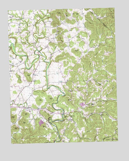
Shopville, KY USGS Topographic Map
Click on map above to begin viewing in our Map Viewer.

This topographic map contains these locations and features:
Feature Name Type Latitude Longitude GNIS ID View Map
AcornPopulated PlaceN37.1331°W84.3777°510208View Map
Bethany ChurchChurchN37.1517°W84.3924°510567View Map
Bobbitt CemeteryCemeteryN37.1767°W84.4838°510826View Map
Bolger HollowValleyN37.1635°W84.3857°510833View Map
Brushy CreekStreamN37.2123°W84.4674°510974View Map
Brushy PointSummitN37.1401°W84.4630°510982View Map
Brushy RidgeRidgeN37.1579°W84.3999°510983View Map
Bullock CemeteryCemeteryN37.1917°W84.3977°511054View Map
Burdine School Number 1SchoolN37.1504°W84.3941°517104View Map
Burdine School Number 2SchoolN37.1609°W84.4044°517105View Map
Burdine ValleyValleyN37.1486°W84.4136°511071View Map
Buzzard KnobSummitN37.1479°W84.4972°511112View Map
Cash KnobSummitN37.2470°W84.4416°511238View Map
Cedar CreekStreamN37.1348°W84.4505°511292View Map
Cedar Gap ChurchChurchN37.1726°W84.4297°511293View Map
Childress CemeteryCemeteryN37.2384°W84.4502°511346View Map
Clifty CreekStreamN37.2167°W84.4694°511409View Map
Coal Pit KnobSummitN37.1637°W84.4305°511440View Map
Cold Spring HollowValleyN37.1309°W84.4985°511462View Map
Custer BluffSummitN37.1529°W84.4836°511688View Map
DahlPopulated PlaceN37.1817°W84.4347°511698View Map
David KnobSummitN37.1398°W84.4952°511728View Map
Doolin KnobSummitN37.1448°W84.4858°511865View Map
Dry Hole (historical)Populated PlaceN37.1975°W84.4886°2725854View Map
Eaton CemeteryCemeteryN37.1773°W84.4213°512003View Map
Egypt KnobSummitN37.1265°W84.4405°512018View Map
ElrodPopulated PlaceN37.2192°W84.4694°512059View Map
Elrod ChurchChurchN37.2356°W84.4694°512060View Map
Emmil BranchStreamN37.1292°W84.4424°512068View Map
Fanny KnobSummitN37.2217°W84.4399°512130View Map
Fellowship KnobSummitN37.1715°W84.4624°512143View Map
Fish Trap BranchStreamN37.2081°W84.4902°512167View Map
Flat Lick ChurchChurchN37.1831°W84.4716°512190View Map
Flat Lick Church CemeteryCemeteryN37.1827°W84.4714°2725611View Map
Flat Lick CreekStreamN37.1454°W84.4591°512193View Map
Flat Lick KnobSummitN37.1890°W84.4794°512194View Map
Gilliand CemeteryCemeteryN37.1790°W84.4963°512313View Map
Gilmore CemeteryCemeteryN37.2151°W84.4560°512316View Map
Hazeldell ChurchChurchN37.2420°W84.4999°493955View Map
Hazeldell SchoolSchoolN37.2434°W84.4972°512624View Map
Heron CemeteryCemeteryN37.1551°W84.4760°512671View Map
Hickory Nut RidgeRidgeN37.1862°W84.4883°512689View Map
Jenkins KnobSummitN37.1665°W84.4538°512992View Map
Latham BranchStreamN37.2006°W84.4524°513212View Map
Leroys SchoolSchoolN37.2231°W84.4466°513343View Map
Liney HollowValleyN37.1952°W84.3890°513440View Map
Logan RidgeRidgeN37.2037°W84.4041°513574View Map
Long BottomBasinN37.2220°W84.4155°513583View Map
Menifee KnobSummitN37.2112°W84.4230°513903View Map
Opossum Strut HollowValleyN37.2479°W84.4023°514366View Map
PlatoPopulated PlaceN37.2329°W84.4177°514638View Map
Plato KnobSummitN37.2451°W84.4211°514639View Map
Plato SchoolSchoolN37.2448°W84.4244°514640View Map
Pleasant Run Baptist ChurchChurchN37.1498°W84.4297°514653View Map
Pleasant Run CemeteryCemeteryN37.1456°W84.4288°514651View Map
Pleasant View ChurchChurchN37.1931°W84.4994°514659View Map
Pleasant View Church CemeteryCemeteryN37.1930°W84.4990°2725627View Map
Price ValleyValleyN37.1642°W84.4173°514768View Map
PublicLocaleN37.1815°W84.3852°514788View Map
Rainey CemeteryCemeteryN37.1570°W84.4149°514830View Map
Randall CemeteryCemeteryN37.1429°W84.4558°514837View Map
Renfro CemeteryCemeteryN37.1834°W84.4333°514887View Map
Rock Lick BranchStreamN37.2073°W84.4869°515031View Map
Rocky BranchStreamN37.2417°W84.4830°515064View Map
School Number 136SchoolN37.1787°W84.3930°517278View Map
Sears CemeteryCemeteryN37.1523°W84.4510°515310View Map
ShopvillePopulated PlaceN37.1587°W84.4799°515373View Map
Shopville - Stab Fire DepartmentBuildingN37.1509°W84.4355°2636480View Map
Shopville DivisionCivilN37.1551°W84.4007°1937254View Map
Short CreekStreamN37.1490°W84.4386°515377View Map
Short Creek SchoolSchoolN37.1459°W84.4274°515383View Map
Silver Star SchoolSchoolN37.2298°W84.4874°515417View Map
Sinking ValleyPopulated PlaceN37.1823°W84.4072°515437View Map
Sinking ValleyValleyN37.1612°W84.4132°515439View Map
Slate BranchStreamN37.2181°W84.4966°515469View Map
StabPopulated PlaceN37.1515°W84.4369°515642View Map
Stewart BranchStreamN37.1567°W84.4811°515698View Map
Sunnyside ChurchChurchN37.2295°W84.4433°515817View Map
Timmy KnobSummitN37.1540°W84.4597°515952View Map
Tom KnobSummitN37.1654°W84.4658°515972View Map
Valley OakPopulated PlaceN37.1892°W84.4722°516172View Map
VanhookPopulated PlaceN37.2140°W84.4022°516175View Map
WelbornPopulated PlaceN37.1984°W84.4977°516258View Map
Wild HollowValleyN37.2229°W84.4995°506724View Map
Wildcat HollowValleyN37.2377°W84.4107°516363View Map
WJDJ-FM (Burnside)TowerN37.1542°W84.4597°517930View Map

Note: Coordinates in the location and feature list above are referenced to NAD83 datum.


Copyright (C) 2008-2025 Ryan Niemi / Sunset Dynamics ... All Rights Reserved