TopoQuest Logo
Do you find TopoQuest useful?
Help keep TopoQuest running and adding new maps/features by donating!
Bitcoin:  19c7KJd3qBynnjoSw5npx9KScwjBe4ifkT
Litecoin:  LXs6TkuXGGXo1vDsWCkWVdjQX94eUKd6ui
Home View Maps Find Maps Find Places Resources & Links


Bobtown, Kentucky Topographic Map

USGS Map Title: Bobtown, KY
USGS Map MRC: 37084B5
DRG (GeoTIFF) Download: o37084b5.tif


Neighboring USGS Topographic Map Quads:


  Eubank, KY  
37084C6
 

  Woodstock, KY  
37084C5
 

  Maretburg, KY  
37084C4
 

  Science Hill, KY  
37084B6
 

  Bobtown, KY  
37084B5
 

  Shopville, KY  
37084B4
 

  Delmer, KY  
37084A6
 

  Somerset, KY  
37084A5
 

  Dykes, KY  
37084A4


Map MRC Location:

N38°
W85°
N38°
W84°
H8 H7 H6 H5 H4 H3 H2 H1
G8 G7 G6 G5 G4 G3 G2 G1
F8 F7 F6 F5 F4 F3 F2 F1
E8 E7 E6 E5 E4 E3 E2 E1
D8 D7 D6 D5 D4 D3 D2 D1
C8 C7 C6 C5 C4 C3 C2 C1
B8 B7 B6 B5 B4 B3 B2 B1
A8 A7 A6 A5 A4 A3 A2 A1
N37°
W85°
N37°
W84°

Bobtown, KY USGS 1:24K Topographic Map Preview:
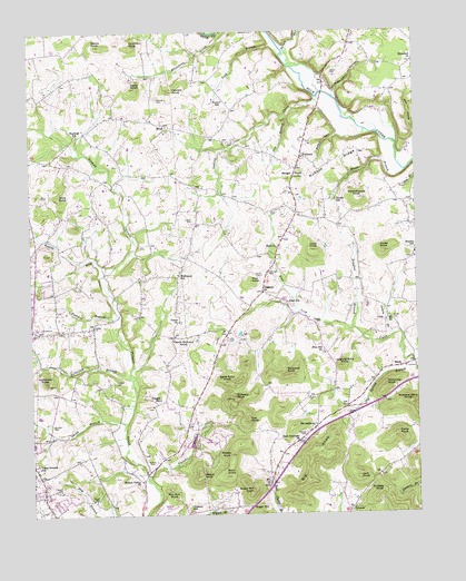
Bobtown, KY USGS Topographic Map
Click on map above to begin viewing in our Map Viewer.

This topographic map contains these locations and features:
Feature Name Type Latitude Longitude GNIS ID View Map
Bald KnobSummitN37.1351°W84.5624°486267View Map
Banks KnobSummitN37.2467°W84.6030°486317View Map
Barnes CemeteryCemeteryN37.1456°W84.5366°486380View Map
BarnesburgPopulated PlaceN37.1479°W84.5327°507455View Map
Barney BranchStreamN37.2451°W84.5416°486415View Map
Bergin KnobSummitN37.2120°W84.5411°486904View Map
Big KnobSummitN37.1401°W84.5347°487204View Map
Big Knob Lookout TowerTowerN37.1402°W84.5344°2725939View Map
Big Spring BranchStreamN37.1629°W84.5008°487263View Map
BobtownPopulated PlaceN37.2179°W84.5369°507542View Map
Buzzard KnobSummitN37.1548°W84.5599°488537View Map
Buzzard Rock KnobSummitN37.1537°W84.5027°488543View Map
Camp Ground SchoolSchoolN37.1376°W84.6227°488700View Map
Cannon KnobSummitN37.2354°W84.5799°488887View Map
Cedar KnobSummitN37.2359°W84.5902°489228View Map
CoinPopulated PlaceN37.1751°W84.5102°507726View Map
Cox KnobSummitN37.1492°W84.5552°490227View Map
Cundiff CemeteryCemeteryN37.1487°W84.6185°490485View Map
DabneyPopulated PlaceN37.1840°W84.5499°507805View Map
Dabney Volunteer Fire DepartmentBuildingN37.1694°W84.5626°2636532View Map
Darky KnobSummitN37.1454°W84.5069°490599View Map
Dollens CemeteryCemeteryN37.1386°W84.5857°490994View Map
Doolin SchoolSchoolN37.2065°W84.5258°491007View Map
Douglas BranchStreamN37.1729°W84.5205°491057View Map
Dry BranchStreamN37.2279°W84.5416°491143View Map
East Somerset ChurchChurchN37.1440°W84.5388°491503View Map
Eden ChurchChurchN37.1942°W84.5452°491556View Map
Eden School (historical)SchoolN37.1798°W84.5422°491558View Map
EtnaPopulated PlaceN37.2259°W84.5802°507951View Map
Etna Church of Christ CemeteryCemeteryN37.2242°W84.5804°2725604View Map
Fletcher BranchStreamN37.1767°W84.5963°492239View Map
Gilmore SchoolSchoolN37.1262°W84.5722°492857View Map
GrundyPopulated PlaceN37.1262°W84.5222°508140View Map
Hewey KnobSummitN37.1406°W84.5608°494101View Map
Holtzclaw BranchStreamN37.1620°W84.5933°494444View Map
Holtzclaw KnobSummitN37.1598°W84.6202°494445View Map
Hubble CemeteryCemeteryN37.1598°W84.5977°494707View Map
Hubble KnobSummitN37.1309°W84.5116°494708View Map
Hubble SchoolSchoolN37.1934°W84.5002°494709View Map
Hyatts ForkStreamN37.1879°W84.6008°494866View Map
Indian CreekStreamN37.2331°W84.5308°494919View Map
Jack KnobSummitN37.1342°W84.5197°495079View Map
James CemeteryCemeteryN37.1512°W84.5230°495158View Map
Jingling Hole KnobSummitN37.1634°W84.5244°495282View Map
Joint KnobSummitN37.1934°W84.5338°495438View Map
Jones KnobSummitN37.1931°W84.5105°495508View Map
Lick BranchStreamN37.2473°W84.5449°496407View Map
MarkPopulated PlaceN37.1631°W84.5044°508542View Map
May KnobSummitN37.1854°W84.5536°497711View Map
Mayfield SchoolSchoolN37.2237°W84.6102°497720View Map
McKinney KnobSummitN37.1579°W84.5102°497916View Map
McKinney SchoolSchoolN37.1870°W84.5769°497917View Map
Meace KnobSummitN37.1354°W84.5705°497954View Map
Mercer CemeteryCemeteryN37.2326°W84.5830°498069View Map
Nelson Valley ChurchChurchN37.1340°W84.5897°499261View Map
Peach Orchard KnobSummitN37.1701°W84.5766°500323View Map
Pine Hill ChurchChurchN37.1667°W84.5302°500694View Map
Price CemeteryCemeteryN37.2034°W84.5449°501319View Map
Red Bud KnobSummitN37.1292°W84.5791°501644View Map
Salem BranchStreamN37.1712°W84.5072°502768View Map
Salem CemeteryCemeteryN37.1759°W84.5080°502770View Map
Saltpeter KnobSummitN37.1615°W84.5427°502850View Map
Sand Rock KnobSummitN37.1595°W84.5619°502936View Map
Schoolhouse KnobSummitN37.2067°W84.5186°503064View Map
Simon HollowValleyN37.2232°W84.5247°503527View Map
Smith BranchStreamN37.1490°W84.5944°503728View Map
Smith CemeteryCemeteryN37.1870°W84.5502°503752View Map
Smithern KnobSummitN37.2467°W84.5911°503809View Map
Sowder CemeteryCemeteryN37.1745°W84.5330°504014View Map
Sugar Camp HollowValleyN37.2341°W84.5257°504640View Map
Sugar HillPopulated PlaceN37.1270°W84.5544°509156View Map
Sugar Hill KnobSummitN37.1312°W84.5538°504670View Map
Surber CemeteryCemeteryN37.2015°W84.5722°504811View Map
Sweeny Church CemeteryCemeteryN37.1531°W84.5862°2725653View Map
Texas SchoolSchoolN37.2323°W84.5624°505102View Map
Union ChurchChurchN37.1754°W84.5766°505778View Map
Vaught BranchStreamN37.1342°W84.5872°506002View Map
Vaught CemeteryCemeteryN37.1290°W84.6055°506003View Map
Vaught CemeteryCemeteryN37.1317°W84.6169°506004View Map
Vaught SchoolSchoolN37.1548°W84.5836°506008View Map
Ware CemeteryCemeteryN37.2078°W84.6208°506221View Map
Ware KnobSummitN37.2079°W84.6155°506222View Map
White BranchStreamN37.2140°W84.5027°506571View Map
Woods CemeteryCemeteryN37.2390°W84.5269°507115View Map
WTHL-FM (Somerset)TowerN37.1312°W84.5541°517739View Map

Note: Coordinates in the location and feature list above are referenced to NAD83 datum.


Copyright (C) 2008-2025 Ryan Niemi / Sunset Dynamics ... All Rights Reserved