TopoQuest Logo
Do you find TopoQuest useful?
Help keep TopoQuest running and adding new maps/features by donating!
Bitcoin:  19c7KJd3qBynnjoSw5npx9KScwjBe4ifkT
Litecoin:  LXs6TkuXGGXo1vDsWCkWVdjQX94eUKd6ui
Home View Maps Find Maps Find Places Resources & Links


Short Creek, Montana Topographic Map

USGS Map Title: Short Creek, MT
USGS Map MRC: 47106E3
DRG (GeoTIFF) Download: o47106e3.tif


Neighboring USGS Topographic Map Quads:


  Ash Creek West, MT  
47106F4
 

  Ash Creek East, MT  
47106F3
 

  Bug Creek, MT  
47106F2
 

  Flat Creek School, MT  
47106E4
 

  Short Creek, MT  
47106E3
 

  Nelson Creek Bay, MT  
47106E2
 

  Hagen Gap, MT  
47106D4
 

  Frank Coulee, MT  
47106D3
 

  Fortyfour Coulee, MT  
47106D2


Map MRC Location:

N48°
W107°
N48°
W106°
H8 H7 H6 H5 H4 H3 H2 H1
G8 G7 G6 G5 G4 G3 G2 G1
F8 F7 F6 F5 F4 F3 F2 F1
E8 E7 E6 E5 E4 E3 E2 E1
D8 D7 D6 D5 D4 D3 D2 D1
C8 C7 C6 C5 C4 C3 C2 C1
B8 B7 B6 B5 B4 B3 B2 B1
A8 A7 A6 A5 A4 A3 A2 A1
N47°
W107°
N47°
W106°

Short Creek, MT USGS 1:24K Topographic Map Preview:
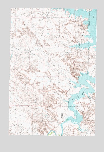
Short Creek, MT USGS Topographic Map
Click on map above to begin viewing in our Map Viewer.

This topographic map contains these locations and features:
Feature Name Type Latitude Longitude GNIS ID View Map
21N42E14CC__01 WellWellN47.5722°W106.3048°823824View Map
21N42E15DC__01 WellWellN47.5736°W106.3145°823830View Map
21N42E15DDCC01 WellWellN47.5728°W106.3092°823828View Map
22N42E34CC__01 WellWellN47.6153°W106.3242°824070View Map
Big Dry CreekStreamN47.5153°W106.2781°768783View Map
Bridge CouleeValleyN47.5103°W106.2992°769216View Map
Claribell Number 11 DamDamN47.5533°W106.3173°797432View Map
Egan CouleeValleyN47.5036°W106.2592°771148View Map
Egan FlatFlatN47.5186°W106.2528°771149View Map
Flint RanchLocaleN47.6183°W106.3242°771470View Map
Lone Tree CreekStreamN47.6247°W106.3131°773598View Map
Mendenhall CouleeValleyN47.5108°W106.2736°774105View Map
Short CreekStreamN47.5914°W106.2536°776513View Map
Shot CouleeValleyN47.5428°W106.2625°776522View Map
Snap CreekStreamN47.5536°W106.2870°776696View Map
Stubby PointCapeN47.5514°W106.2564°777273View Map
Timber CreekStreamN47.5158°W106.2836°777663View Map
Twitchell Number 2 DamDamN47.5783°W106.3739°797433View Map
Twitchell Post Office (historical)Post OfficeN47.6208°W106.2700°1716007View Map

Note: Coordinates in the location and feature list above are referenced to NAD83 datum.


Copyright (C) 2008-2024 Ryan Niemi / Sunset Dynamics ... All Rights Reserved