TopoQuest Logo
Do you find TopoQuest useful?
Help keep TopoQuest running and adding new maps/features by donating!
Bitcoin:  19c7KJd3qBynnjoSw5npx9KScwjBe4ifkT
Litecoin:  LXs6TkuXGGXo1vDsWCkWVdjQX94eUKd6ui
Home View Maps Find Maps Find Places Resources & Links


Sidney, Oregon Topographic Map

USGS Map Title: Sidney, OR
USGS Map MRC: 44123G1
DRG (GeoTIFF) Download: o44123g1.tif


Neighboring USGS Topographic Map Quads:


  Rickreall, OR  
44123H2
 

  Salem West, OR  
44123H1
 

  Salem East, OR  
44122H8
 

  Monmouth, OR  
44123G2
 

  Sidney, OR  
44123G1
 

  Turner, OR  
44122G8
 

  Lewisburg, OR  
44123F2
 

  Albany, OR  
44123F1
 

  Crabtree, OR  
44122F8


Map MRC Location:

N45°
W124°
N45°
W123°
H8 H7 H6 H5 H4 H3 H2 H1
G8 G7 G6 G5 G4 G3 G2 G1
F8 F7 F6 F5 F4 F3 F2 F1
E8 E7 E6 E5 E4 E3 E2 E1
D8 D7 D6 D5 D4 D3 D2 D1
C8 C7 C6 C5 C4 C3 C2 C1
B8 B7 B6 B5 B4 B3 B2 B1
A8 A7 A6 A5 A4 A3 A2 A1
N44°
W124°
N44°
W123°

Sidney, OR USGS 1:24K Topographic Map Preview:
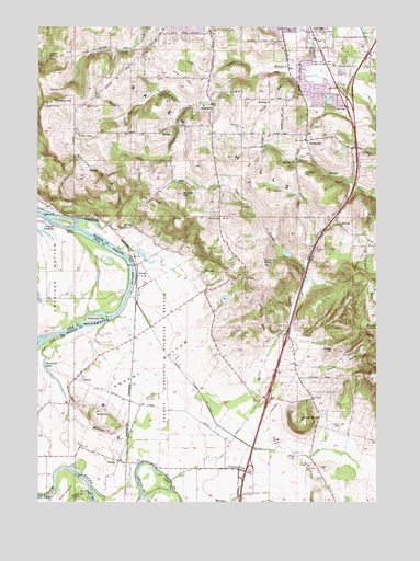
Sidney, OR USGS Topographic Map
Click on map above to begin viewing in our Map Viewer.

This topographic map contains these locations and features:
Feature Name Type Latitude Longitude GNIS ID View Map
Abiqua AcademySchoolN44.8543°W123.0652°1125674View Map
American BottomFlatN44.8087°W123.1198°1116912View Map
Ankeny BottomFlatN44.7857°W123.0851°1116955View Map
Ankeny HillRidgeN44.8243°W123.0582°1116956View Map
Ankeny National Wildlife RefugeParkN44.7864°W123.0771°1116957View Map
Art Brandt Airport (historical)AirportN44.7582°W123.0276°1639143View Map
Barnett KnollSummitN44.7962°W123.0015°1136034View Map
Bashaw CreekStreamN44.7779°W123.1159°1117291View Map
Battle Creek Country ClubLocaleN44.8651°W123.0201°1163678View Map
Bunker HillSummitN44.8310°W123.0729°1118313View Map
Bureau of Land Management Salem District OfficeBuildingN44.8744°W123.0236°2737748View Map
Camp CrestwoodLocaleN44.8254°W123.0318°1639141View Map
Cannon FarmLocaleN44.8703°W123.1069°2663941View Map
Chehulpum CreekStreamN44.7557°W123.0773°1118843View Map
Cherriots Sunnyside / Turner Interchange Park and RideLocaleN44.8426°W123.0098°2699221View Map
Church on the HillChurchN44.8408°W123.0067°2508181View Map
Cole IslandIslandN44.7532°W123.1159°1119132View Map
Cox CemeteryCemeteryN44.8193°W123.0776°1164028View Map
Creswell CanyonValleyN44.7937°W123.0306°1119542View Map
Crossler Middle SchoolSchoolN44.8745°W123.0636°2485907View Map
Crystal SpringSpringN44.8673°W123.1184°1119611View Map
Davidson FieldAirportN44.7974°W123.0991°2645979View Map
Dencer (historical)Populated PlaceN44.8721°W123.0818°1130129View Map
Dencer Post Office (historical)Post OfficeN44.8721°W123.0818°1165144View Map
Elkins HelipadAirportN44.8601°W123.0384°2699354View Map
Eoff ReservoirReservoirN44.8151°W123.0344°1130131View Map
Fordmill (historical)LocaleN44.8223°W123.0990°1637764View Map
Gilmour Ag AirAirportN44.7545°W123.0463°1131755View Map
Jackson HillSummitN44.8360°W123.0282°1136417View Map
Jory CemeteryCemeteryN44.8512°W123.0680°1122538View Map
Jory CreekStreamN44.8640°W123.0401°1122539View Map
Jory HillRidgeN44.8623°W123.0718°1122540View Map
Joryville County ParkParkN44.8568°W123.0784°1122541View Map
Judson LandingLocaleN44.8226°W123.1201°1122550View Map
Judson RocksBarN44.8210°W123.1123°1158302View Map
Keesneck LakeLakeN44.7835°W123.1212°1122652View Map
KVDO-TVTowerN44.8546°W123.1226°1131256View Map
Lee Elementary SchoolSchoolN44.8740°W123.0036°2485932View Map
Lee School ParkParkN44.8743°W123.0043°2040238View Map
Lightner Post Office (historical)Post OfficeN44.8437°W123.0640°1164474View Map
Looney ButteSummitN44.7721°W123.0295°1123475View Map
Looney CemeteryCemeteryN44.7703°W123.0146°1123476View Map
Miller CreekStreamN44.7765°W123.0640°1124190View Map
Morlan Airfield (historical)AirportN44.8068°W123.1165°1131644View Map
Neil CreekStreamN44.8126°W123.0290°1124643View Map
Ornoname 10 DamDamN44.8148°W123.0329°1163816View Map
Porter SloughStreamN44.7554°W123.1068°1130135View Map
Powell CreekStreamN44.8623°W123.0229°1125634View Map
Prospect HillSummitN44.8546°W123.1223°1136659View Map
Rees City ParkParkN44.8582°W123.0268°1966209View Map
Reese HillSummitN44.8582°W123.0429°1130130View Map
Reforestation Services HelipadAirportN44.8723°W123.0251°2699732View Map
Relf (historical)LocaleN44.7937°W123.0907°1637765View Map
River Bend DamDamN44.8148°W123.0895°1133661View Map
River Bend Reservoir Number TwoReservoirN44.8152°W123.0881°1130132View Map
Roby (historical)LocaleN44.7762°W123.1151°1130134View Map
Roby HillSummitN44.7735°W123.1045°1126132View Map
Rock CreekStreamN44.7943°W123.1157°1126149View Map
RosedalePopulated PlaceN44.8546°W123.0615°1126302View Map
Rosedale Elementary SchoolSchoolN44.8543°W123.0651°1639142View Map
Rosedale Friends CemeteryCemeteryN44.8487°W123.0515°1126303View Map
Rosedale Post Office (historical)Post OfficeN44.8546°W123.0615°1165884View Map
Salem HillsRangeN44.8432°W123.0684°1136725View Map
SidneyLocaleN44.8098°W123.0893°1126948View Map
SidneyPopulated PlaceN44.7832°W123.1095°1136753View Map
Sidney Post Office (historical)Post OfficeN44.7832°W123.1095°1165945View Map
Sidney Power DitchCanalN44.7826°W123.0712°1126949View Map
South Hill HelipadAirportN44.8474°W123.0230°2699827View Map
Spring Lake DamDamN44.8015°W123.0579°1131604View Map
Spring ReservoirReservoirN44.8033°W123.0571°1130133View Map
Steiwer HillSummitN44.7901°W123.0173°1127584View Map
SunnysidePopulated PlaceN44.8448°W123.0268°1127733View Map
TalbotPopulated PlaceN44.7610°W123.0962°1637863View Map
Talbot Post Office (historical)Post OfficeN44.7610°W123.0962°1166029View Map
Twin HillsSummitN44.8123°W123.0426°1136850View Map
Wagoner AirportAirportN44.8488°W123.0441°1131136View Map
Waln CreekStreamN44.8623°W123.0229°1128615View Map
Weaver GulchValleyN44.7871°W123.0387°1128751View Map
Whiteman BarBarN44.7979°W123.1051°1129014View Map
Wild Fawn ParkParkN44.8548°W123.0359°2058268View Map
Wilkerson CreekStreamN44.8243°W123.1118°1129091View Map
Willamette Christian SchoolSchoolN44.8409°W123.0066°2486100View Map
Wintel (historical)LocaleN44.7776°W123.0929°1130128View Map

Note: Coordinates in the location and feature list above are referenced to NAD83 datum.


Copyright (C) 2008-2024 Ryan Niemi / Sunset Dynamics ... All Rights Reserved