TopoQuest Logo
Do you find TopoQuest useful?
Help keep TopoQuest running and adding new maps/features by donating!
Bitcoin:  19c7KJd3qBynnjoSw5npx9KScwjBe4ifkT
Litecoin:  LXs6TkuXGGXo1vDsWCkWVdjQX94eUKd6ui
Home View Maps Find Maps Find Places Resources & Links


Simcoe, Alabama Topographic Map

USGS Map Title: Simcoe, AL
USGS Map MRC: 34086B6
DRG (GeoTIFF) Download: o34086b6.tif


Neighboring USGS Topographic Map Quads:


  Eva, AL  
34086C7
 

  Lawrence Cove, AL  
34086C6
 

  Hulaco, AL  
34086C5
 

  Cullman, AL  
34086B7
 

  Simcoe, AL  
34086B6
 

  Holly Pond, AL  
34086B5
 

  Hanceville, AL  
34086A7
 

  Garden City, AL  
34086A6
 

  Blountsville, AL  
34086A5


Map MRC Location:

N35°
W87°
N35°
W86°
H8 H7 H6 H5 H4 H3 H2 H1
G8 G7 G6 G5 G4 G3 G2 G1
F8 F7 F6 F5 F4 F3 F2 F1
E8 E7 E6 E5 E4 E3 E2 E1
D8 D7 D6 D5 D4 D3 D2 D1
C8 C7 C6 C5 C4 C3 C2 C1
B8 B7 B6 B5 B4 B3 B2 B1
A8 A7 A6 A5 A4 A3 A2 A1
N34°
W87°
N34°
W86°

Simcoe, AL USGS 1:24K Topographic Map Preview:
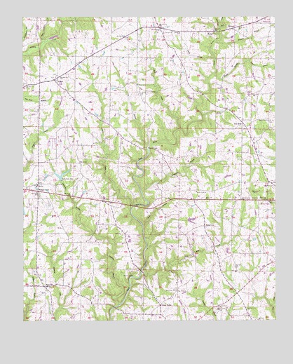
Simcoe, AL USGS Topographic Map
Click on map above to begin viewing in our Map Viewer.

This topographic map contains these locations and features:
Feature Name Type Latitude Longitude GNIS ID View Map
Antioch Missionary Baptist ChurchChurchN34.2223°W86.6925°113171View Map
Antioch SchoolSchoolN34.2229°W86.6936°113185View Map
BaileytownPopulated PlaceN34.1637°W86.6597°113367View Map
Bear BranchStreamN34.1640°W86.6900°113636View Map
BerlinPopulated PlaceN34.1815°W86.7422°157889View Map
Berlin Baptist ChurchChurchN34.1765°W86.7431°1805420View Map
Berlin Volunteer Fire Department Station 1BuildingN34.1789°W86.7437°2683103View Map
Berlin Volunteer Fire Department Station 2BuildingN34.1395°W86.7393°2683039View Map
Bethel CemeteryCemeteryN34.1809°W86.7342°1805421View Map
Bethel Primitive Baptist ChurchChurchN34.1809°W86.7336°114077View Map
Bibleway Pentecostal ChurchChurchN34.2329°W86.6925°134863View Map
BirdsongPopulated PlaceN34.2451°W86.6467°114371View Map
Brindley CemeteryCemeteryN34.2409°W86.7425°114920View Map
Brooklyn Holiness ChurchChurchN34.2237°W86.6308°123490View Map
Center Point Baptist ChurchChurchN34.1782°W86.6642°115858View Map
Center Point CemeteryCemeteryN34.1779°W86.6644°1805425View Map
Church of ChristChurchN34.1751°W86.6294°1730499View Map
Concord CemeteryCemeteryN34.2440°W86.6764°1805429View Map
Concord Missionary Baptist ChurchChurchN34.2443°W86.6753°116499View Map
Copperas BranchStreamN34.1315°W86.7022°116615View Map
Dry BranchStreamN34.2043°W86.6717°117504View Map
Duck CreekStreamN34.2459°W86.6517°117613View Map
Duck River Baptist ChurchChurchN34.1376°W86.6747°117621View Map
Duck River CemeteryCemeteryN34.1384°W86.6744°134889View Map
Fairview Volunteer Fire and Rescue Station 1BuildingN34.2460°W86.6867°2683181View Map
Henderson BranchStreamN34.1779°W86.6906°119947View Map
Holly Pond CemeteryCemeteryN34.1812°W86.6261°120277View Map
Holly Pond DivisionCivilN34.1618°W86.6357°165733View Map
Hunter BranchStreamN34.2262°W86.6556°120551View Map
Indian CreekStreamN34.1707°W86.6961°120638View Map
Lake EgeReservoirN34.1964°W86.6620°131977View Map
Lidy S LakeReservoirN34.1801°W86.7333°131963View Map
Mount Olive CemeteryCemeteryN34.2118°W86.7425°1805442View Map
Mount Olive Congregational Methodist ChurchChurchN34.2120°W86.7419°152470View Map
Mount Vernon CemeteryCemeteryN34.2437°W86.6575°1730471View Map
Mount Vernon Primitive Baptist ChurchChurchN34.2437°W86.6575°152515View Map
Mount Zion Missionary Baptist ChurchChurchN34.1398°W86.7425°134939View Map
New Home ChurchChurchN34.1373°W86.6736°123775View Map
New HopePopulated PlaceN34.2051°W86.6411°123784View Map
New Hope Number 2 Baptist ChurchChurchN34.2082°W86.6408°1730531View Map
New Hope Number 2 CemeteryCemeteryN34.2079°W86.6422°1805448View Map
North WalterPopulated PlaceN34.1315°W86.6819°124019View Map
Nunnley BranchStreamN34.2398°W86.6544°124046View Map
Oak LevelLocaleN34.1898°W86.7214°124120View Map
Oak Level Baptist ChurchChurchN34.1890°W86.7214°134946View Map
Oak Level CemeteryCemeteryN34.1887°W86.7208°1805449View Map
Pilgrim Rest CemeteryCemeteryN34.2079°W86.6278°124732View Map
Plainview Baptist ChurchChurchN34.1712°W86.6942°134949View Map
Plainview ChurchChurchN34.1659°W86.6822°124926View Map
Rock CreekStreamN34.2043°W86.6717°125757View Map
Roy Shaw DamDamN34.1418°W86.6567°131952View Map
Shady Grove East Baptist ChurchChurchN34.1304°W86.6397°153393View Map
Shaw LakeReservoirN34.1428°W86.6572°131951View Map
Short CreekStreamN34.2382°W86.7406°126812View Map
SimcoePopulated PlaceN34.2243°W86.7344°126860View Map
Simcoe Baptist ChurchChurchN34.2254°W86.7339°1730538View Map
Simcoe CemeteryCemeteryN34.2265°W86.7333°1729940View Map
Simcoe ChurchChurchN34.2309°W86.7225°126861View Map
Simcoe DivisionCivilN34.2402°W86.7259°165736View Map
Simcoe Elementary SchoolSchoolN34.2251°W86.7386°134964View Map
Simcoe United Methodist ChurchChurchN34.2257°W86.7333°134963View Map
Smith BranchStreamN34.2332°W86.6547°126994View Map
Tanner BridgeBridgeN34.1965°W86.6867°127663View Map
Tarkiln BranchStreamN34.2320°W86.6380°127695View Map
Thornton BridgeBridgeN34.1429°W86.6956°127928View Map
Tommy Ege DamDamN34.1968°W86.6617°131976View Map
Town of FairviewCivilN34.2477°W86.6843°2406480View Map
Twin Fork LakeReservoirN34.1850°W86.7309°128227View Map
Two Mile CreekStreamN34.1465°W86.6906°128232View Map
Union CemeteryCemeteryN34.1304°W86.6525°1805456View Map
Union Freewill Baptist ChurchChurchN34.1307°W86.6525°153772View Map
Unity Baptist ChurchChurchN34.1607°W86.7017°128361View Map
W I Walker DamDamN34.1801°W86.7333°131962View Map
Walkers CornerPopulated PlaceN34.1782°W86.7425°128528View Map
WeltiPopulated PlaceN34.1393°W86.7389°153923View Map
Welti CemeteryCemeteryN34.1390°W86.7378°1730287View Map
Welti Cumberland Presbyterian ChurchChurchN34.1384°W86.7383°134978View Map
Welti DivisionCivilN34.1356°W86.7290°165738View Map
Welti Junior High SchoolSchoolN34.1418°W86.7408°134979View Map
Wolf CreekStreamN34.2459°W86.6517°129160View Map

Note: Coordinates in the location and feature list above are referenced to NAD83 datum.


Copyright (C) 2008-2024 Ryan Niemi / Sunset Dynamics ... All Rights Reserved