TopoQuest Logo
Do you find TopoQuest useful?
Help keep TopoQuest running and adding new maps/features by donating!
Bitcoin:  19c7KJd3qBynnjoSw5npx9KScwjBe4ifkT
Litecoin:  LXs6TkuXGGXo1vDsWCkWVdjQX94eUKd6ui
Home View Maps Find Maps Find Places Resources & Links


Hulaco, Alabama Topographic Map

USGS Map Title: Hulaco, AL
USGS Map MRC: 34086C5
DRG (GeoTIFF) Download: o34086c5.tif


Neighboring USGS Topographic Map Quads:


  Center Grove, AL  
34086D6
 

  Newsome Sinks, AL  
34086D5
 

  Guntersville Dam, AL  
34086D4
 

  Lawrence Cove, AL  
34086C6
 

  Hulaco, AL  
34086C5
 

  Arab, AL  
34086C4
 

  Simcoe, AL  
34086B6
 

  Holly Pond, AL  
34086B5
 

  Brooksville, AL  
34086B4


Map MRC Location:

N35°
W87°
N35°
W86°
H8 H7 H6 H5 H4 H3 H2 H1
G8 G7 G6 G5 G4 G3 G2 G1
F8 F7 F6 F5 F4 F3 F2 F1
E8 E7 E6 E5 E4 E3 E2 E1
D8 D7 D6 D5 D4 D3 D2 D1
C8 C7 C6 C5 C4 C3 C2 C1
B8 B7 B6 B5 B4 B3 B2 B1
A8 A7 A6 A5 A4 A3 A2 A1
N34°
W87°
N34°
W86°

Hulaco, AL USGS 1:24K Topographic Map Preview:
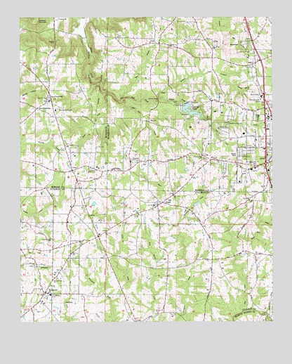
Hulaco, AL USGS Topographic Map
Click on map above to begin viewing in our Map Viewer.

This topographic map contains these locations and features:
Feature Name Type Latitude Longitude GNIS ID View Map
Adams Poultry FarmsLocaleN34.2775°W86.5131°2516615View Map
Arab Country ClubLocaleN34.3295°W86.5264°164274View Map
Arab Fire and Emergency Medical Services DepartmentBuildingN34.3211°W86.5048°2682820View Map
Arab Junior High SchoolSchoolN34.3126°W86.5103°139327View Map
BaileytonPopulated PlaceN34.2623°W86.6128°113366View Map
Baileyton CemeteryCemeteryN34.2604°W86.6094°134853View Map
Baileyton Junior High SchoolSchoolN34.2612°W86.6103°134854View Map
Baileyton Post OfficePost OfficeN34.2630°W86.6130°166636View Map
Baileyton United Methodist ChurchChurchN34.2640°W86.6111°134855View Map
Baileyton Volunteer Fire Department Station 1BuildingN34.2705°W86.6154°2683059View Map
Baileyton-Joppa DivisionCivilN34.2655°W86.5732°165728View Map
Berry CreekStreamN34.2951°W86.5775°113962View Map
Bobby Briscoe FarmsLocaleN34.3572°W86.5589°2516608View Map
Corinth CemeteryCemeteryN34.2940°W86.5658°1730217View Map
Corinth East Baptist ChurchChurchN34.2940°W86.5658°116631View Map
Cranford BranchStreamN34.3526°W86.5275°116817View Map
Crawford CemeteryCemeteryN34.3743°W86.6055°116824View Map
Crawford ChuteBasinN34.3648°W86.6069°116827View Map
Crawford Spring Number 4SpringN34.3679°W86.6239°148967View Map
EddyPopulated PlaceN34.3554°W86.5094°117849View Map
Eddy Baptist ChurchChurchN34.3612°W86.5003°149238View Map
EgyptPopulated PlaceN34.3443°W86.5339°156300View Map
Gilliam CreekStreamN34.3418°W86.5547°118959View Map
Gilliam Springs Baptist ChurchChurchN34.3409°W86.5055°118962View Map
Gilliam Springs CemeteryCemeteryN34.3420°W86.5064°147474View Map
Grandiflora Church of ChristChurchN34.2840°W86.6100°119227View Map
Harvells Store (historical)LocaleN34.3120°W86.5708°139396View Map
Hebron CemeteryCemeteryN34.3131°W86.5903°139803View Map
Hebron Church of ChristChurchN34.3129°W86.5886°119922View Map
Hilltop ChurchChurchN34.3220°W86.5867°151810View Map
Hog BranchStreamN34.3418°W86.5725°120184View Map
Hog JawPopulated PlaceN34.3323°W86.5603°120194View Map
Hog Jaw CreekStreamN34.3406°W86.5742°120195View Map
HulacoPopulated PlaceN34.3123°W86.5986°120540View Map
Hulaco School (historical)SchoolN34.2973°W86.5994°149920View Map
Independent ChurchChurchN34.3176°W86.5330°139407View Map
John H Burden DairyLocaleN34.3358°W86.5775°2516604View Map
JoppaPopulated PlaceN34.2979°W86.5561°121033View Map
Joppa Census Designated PlaceCensusN34.2981°W86.5506°2628595View Map
Joppa Church of GodChurchN34.2984°W86.5572°1730524View Map
Joppa CreekStreamN34.2901°W86.5461°121034View Map
Joppa Junior High SchoolSchoolN34.2979°W86.5586°134919View Map
Joppa Post OfficePost OfficeN34.2961°W86.5599°166641View Map
Joppa United Methodist ChurchChurchN34.2962°W86.5592°134918View Map
Joppa Volunteer Fire Department Station 1BuildingN34.2946°W86.5691°2682905View Map
Joppa Volunteer Fire Department Station 2BuildingN34.2829°W86.5309°2682725View Map
King BranchStreamN34.2640°W86.5603°121206View Map
Lakeview FarmsLocaleN34.2503°W86.5081°2516607View Map
Liberty ChurchChurchN34.3179°W86.5336°121539View Map
Little Vine CemeteryCemeteryN34.3418°W86.6122°139518View Map
Little Vine Primitive Baptist ChurchChurchN34.3420°W86.6119°152118View Map
May Apple (historical)Populated PlaceN34.3145°W86.5303°139435View Map
MeadowoodPopulated PlaceN34.3637°W86.5103°122619View Map
Mill Pond BridgeBridgeN34.3412°W86.5555°122811View Map
Mill Pond CreekStreamN34.3418°W86.5725°152333View Map
Moon HollowValleyN34.3687°W86.5933°122982View Map
Mount Herman School (historical)SchoolN34.2832°W86.5953°134937View Map
Mount Hermon Baptist ChurchChurchN34.2829°W86.5953°152425View Map
Mount Hermon CemeteryCemeteryN34.2829°W86.5955°1805440View Map
Mount Oak CemeteryCemeteryN34.3634°W86.5511°147485View Map
Mount Oak Methodist ChurchChurchN34.3631°W86.5497°152454View Map
New Jerusalem Baptist ChurchChurchN34.3032°W86.5469°1730532View Map
Normal Industrial and Collegiate Institute (historical)SchoolN34.2979°W86.5586°134943View Map
North ArabPopulated PlaceN34.3431°W86.5044°123984View Map
Open Door Christian Fellowship ChurchChurchN34.2826°W86.5847°1730535View Map
Perkins CreekStreamN34.3418°W86.5550°124612View Map
Pine LakeReservoirN34.3370°W86.5408°124822View Map
Pine Lake DamDamN34.3518°W86.5250°132000View Map
Pine Lake VillagePopulated PlaceN34.3370°W86.5394°124824View Map
Pleasant Grove CemeteryCemeteryN34.3226°W86.6022°139574View Map
Pleasant Grove Methodist ChurchChurchN34.3220°W86.6011°152969View Map
Pleasant Valley ChurchChurchN34.3176°W86.5353°125044View Map
RicePopulated PlaceN34.3184°W86.5336°156961View Map
Rice CemeteryCemeteryN34.3190°W86.5344°147504View Map
Rice SchoolSchoolN34.3184°W86.5350°139472View Map
Riley Maze CreekStreamN34.2832°W86.5183°125641View Map
RuthPopulated PlaceN34.3643°W86.5567°126049View Map
Ruth Baptist ChurchChurchN34.3651°W86.5603°149253View Map
Ruth School (historical)SchoolN34.3626°W86.5500°149254View Map
Ruth Volunteer Fire DepartmentBuildingN34.3664°W86.5547°2683000View Map
Ryan Baptist ChurchChurchN34.3370°W86.6072°139588View Map
Ryan CrossroadsPopulated PlaceN34.3420°W86.6103°153235View Map
Ryan High SchoolSchoolN34.3407°W86.6105°148998View Map
Ryan Memorial GardensCemeteryN34.3373°W86.6061°126068View Map
Sunset AcresPopulated PlaceN34.3193°W86.5139°127563View Map
Tibb CreekStreamN34.2543°W86.5150°153693View Map
Town of BaileytonCivilN34.2608°W86.6082°2405198View Map
Tri - County Volunteer Fire DepartmentBuildingN34.3097°W86.5971°2683247View Map
Union HillPopulated PlaceN34.2998°W86.5119°157188View Map
Union Hill CemeteryCemeteryN34.3018°W86.5117°1730227View Map
Union Hill Methodist ChurchChurchN34.3009°W86.5108°134973View Map
Warrior CreekStreamN34.2543°W86.5150°128598View Map
Westside Baptist ChurchChurchN34.3154°W86.5108°128801View Map
Winn CrossroadsPopulated PlaceN34.3379°W86.6164°157272View Map
Wolf CreekStreamN34.3306°W86.5297°129161View Map
Yates CreekStreamN34.3440°W86.5808°129276View Map

Note: Coordinates in the location and feature list above are referenced to NAD83 datum.


Copyright (C) 2008-2024 Ryan Niemi / Sunset Dynamics ... All Rights Reserved