TopoQuest Logo
Do you find TopoQuest useful?
Help keep TopoQuest running and adding new maps/features by donating!
Bitcoin:  19c7KJd3qBynnjoSw5npx9KScwjBe4ifkT
Litecoin:  LXs6TkuXGGXo1vDsWCkWVdjQX94eUKd6ui
Home View Maps Find Maps Find Places Resources & Links


Lawrence Cove, Alabama Topographic Map

USGS Map Title: Lawrence Cove, AL
USGS Map MRC: 34086C6
DRG (GeoTIFF) Download: o34086c6.tif


Neighboring USGS Topographic Map Quads:


  Somerville, AL  
34086D7
 

  Center Grove, AL  
34086D6
 

  Newsome Sinks, AL  
34086D5
 

  Eva, AL  
34086C7
 

  Lawrence Cove, AL  
34086C6
 

  Hulaco, AL  
34086C5
 

  Cullman, AL  
34086B7
 

  Simcoe, AL  
34086B6
 

  Holly Pond, AL  
34086B5


Map MRC Location:

N35°
W87°
N35°
W86°
H8 H7 H6 H5 H4 H3 H2 H1
G8 G7 G6 G5 G4 G3 G2 G1
F8 F7 F6 F5 F4 F3 F2 F1
E8 E7 E6 E5 E4 E3 E2 E1
D8 D7 D6 D5 D4 D3 D2 D1
C8 C7 C6 C5 C4 C3 C2 C1
B8 B7 B6 B5 B4 B3 B2 B1
A8 A7 A6 A5 A4 A3 A2 A1
N34°
W87°
N34°
W86°

Lawrence Cove, AL USGS 1:24K Topographic Map Preview:
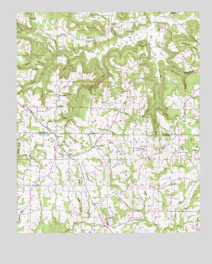
Lawrence Cove, AL USGS Topographic Map
Click on map above to begin viewing in our Map Viewer.

This topographic map contains these locations and features:
Feature Name Type Latitude Longitude GNIS ID View Map
Albritton CreekStreamN34.3209°W86.6561°112972View Map
Antioch Methodist ChurchChurchN34.2773°W86.6689°134848View Map
Bates HollowValleyN34.3493°W86.7136°113565View Map
Bethel - Gum Pond Volunteer Fire DepartmentBuildingN34.3236°W86.6774°2683262View Map
Bethel CemeteryCemeteryN34.3234°W86.6875°139702View Map
Bethel United Methodist ChurchChurchN34.3234°W86.6889°139703View Map
Canaan CemeteryCemeteryN34.3012°W86.6855°115518View Map
Canaan Church (historical)ChurchN34.3012°W86.6853°1700287View Map
Center DalePopulated PlaceN34.3212°W86.7231°115839View Map
Center Dale School (historical)SchoolN34.3215°W86.7244°139725View Map
Copper Spring HollowValleyN34.3640°W86.7467°116614View Map
County LinePopulated PlaceN34.2993°W86.6981°116713View Map
County Line School (historical)SchoolN34.3004°W86.6994°1700288View Map
Crossroads ChurchChurchN34.2773°W86.7392°116907View Map
Crow BridgeBridgeN34.3695°W86.6544°116912View Map
Daniels Chapel Baptist ChurchChurchN34.3279°W86.7219°117046View Map
Daniels Chapel CemeteryCemeteryN34.3281°W86.7214°139747View Map
Derrick HollowValleyN34.3448°W86.7300°117239View Map
Dry CreekStreamN34.3379°W86.6525°117546View Map
Dry Creek SpringSpringN34.3382°W86.6544°148970View Map
Duck Creek CemeteryCemeteryN34.2579°W86.6667°1730218View Map
Duck Creek Primitive Baptist ChurchChurchN34.2582°W86.6669°117614View Map
Etha Baptist ChurchChurchN34.2998°W86.7222°118044View Map
Etha CemeteryCemeteryN34.2954°W86.7167°1730324View Map
Eva DivisionCivilN34.3539°W86.6996°165912View Map
FairviewPopulated PlaceN34.2554°W86.6881°118132View Map
Fairview CemeteryCemeteryN34.2593°W86.6922°1729937View Map
Fairview CemeteryCemeteryN34.2526°W86.6853°1730285View Map
Fairview High SchoolSchoolN34.2548°W86.6878°134896View Map
Fairview United Methodist ChurchChurchN34.2590°W86.6925°141352View Map
Fairview Volunteer Fire and Rescue Station 2BuildingN34.2666°W86.6973°2683084View Map
Fall CreekStreamN34.3226°W86.6528°118179View Map
First Baptist Church of FairviewChurchN34.2529°W86.6847°134899View Map
Ford BranchStreamN34.3532°W86.7192°118475View Map
Friendship ChurchChurchN34.2998°W86.7222°118708View Map
Frost CreekStreamN34.3507°W86.7244°118733View Map
Goat HollowValleyN34.3387°W86.7325°119066View Map
Greasy CoveValleyN34.3695°W86.6881°119312View Map
Gum PondLocaleN34.3309°W86.6756°119479View Map
Gum Pond CemeteryCemeteryN34.3318°W86.6744°139792View Map
Gum Pond Primitive Baptist ChurchChurchN34.3326°W86.6742°139793View Map
Gum Pond School (historical)SchoolN34.3326°W86.6742°139794View Map
Harmony CemeteryCemeteryN34.3615°W86.7194°139799View Map
Harmony Primitive Baptist ChurchChurchN34.3618°W86.7203°119757View Map
Herring BranchStreamN34.2740°W86.6261°119999View Map
Keller CreekStreamN34.3512°W86.6925°151943View Map
Kennedy CreekStreamN34.3398°W86.6367°121152View Map
Kimbrell BranchStreamN34.2932°W86.7489°121198View Map
Lawrence Chapel CemeteryCemeteryN34.2615°W86.6989°121433View Map
Lawrence Chapel Methodist Episcopal Church (historical)ChurchN34.2615°W86.6986°134923View Map
Lawrence CoveValleyN34.3648°W86.6619°121435View Map
Lawrence Cove Baptist ChurchChurchN34.3701°W86.7383°152003View Map
Lawrence Cove CemeteryCemeteryN34.3706°W86.7389°139510View Map
Lawrence Cove SchoolSchoolN34.3604°W86.7028°121436View Map
Long BranchStreamN34.2526°W86.6417°121991View Map
Lystra Baptist ChurchChurchN34.2787°W86.6272°122131View Map
Lystra CemeteryCemeteryN34.2781°W86.6278°1730170View Map
Macedonia Church of ChristChurchN34.3034°W86.7228°1730527View Map
Macedonia Church of ChristChurchN34.2945°W86.7097°152190View Map
Mardis BranchStreamN34.3154°W86.6706°122277View Map
Martin HollowValleyN34.3529°W86.7206°122331View Map
Martin SpringSpringN34.3665°W86.6597°148984View Map
McAnear CreekStreamN34.3543°W86.6544°122440View Map
Minnow CreekStreamN34.2579°W86.7044°122873View Map
Mount Olive Church (historical)ChurchN34.3232°W86.7264°139537View Map
Mount Pisgah CemeteryCemeteryN34.2770°W86.6450°1730334View Map
Mount Pisgah School (historical)SchoolN34.2770°W86.6453°134938View Map
Mount Pisgah Upper Cumberland Presbyterian ChurchChurchN34.2768°W86.6453°152488View Map
Mud CreekStreamN34.3723°W86.6553°123543View Map
Mud Creek SpringSpringN34.3351°W86.6517°148988View Map
Pentecostal ChurchChurchN34.3065°W86.7000°124599View Map
Persimmon KnobSummitN34.3548°W86.6647°124632View Map
Persimmon Knob SpringSpringN34.3551°W86.6586°148993View Map
Pied CreekStreamN34.2551°W86.6569°124703View Map
Pleasant RidgeRidgeN34.3545°W86.6300°125031View Map
Pleasant Ridge ChurchChurchN34.3640°W86.6439°139576View Map
Pruitt BranchStreamN34.3151°W86.7153°125345View Map
Puckett HollowValleyN34.3651°W86.7478°125352View Map
Roan SpringSpringN34.3651°W86.6689°148994View Map
Rock CreekStreamN34.3576°W86.6758°125758View Map
Rock Creek Baptist ChurchChurchN34.3673°W86.6858°153178View Map
Rock Creek Baptist ChurchChurchN34.3670°W86.6833°139587View Map
Rock Creek Volunteer Fire DepartmentBuildingN34.3659°W86.6823°2683242View Map
Ryan BridgeBridgeN34.3584°W86.6678°126064View Map
Section HollowValleyN34.3479°W86.6494°126525View Map
Self MountainRidgeN34.3670°W86.7047°126532View Map
Springer ChurchChurchN34.3587°W86.7028°153546View Map
Sugarloaf HillSummitN34.3734°W86.6439°127510View Map
Welcome Baptist ChurchChurchN34.2923°W86.6622°128724View Map
Welcome CemeteryCemeteryN34.2926°W86.6614°1729941View Map
Welcome FallsFallsN34.3159°W86.6647°128725View Map
Widner CreekStreamN34.3226°W86.6531°128939View Map
Yarbrough BranchStreamN34.2623°W86.6644°129272View Map

Note: Coordinates in the location and feature list above are referenced to NAD83 datum.


Copyright (C) 2008-2024 Ryan Niemi / Sunset Dynamics ... All Rights Reserved