TopoQuest Logo
Do you find TopoQuest useful?
Help keep TopoQuest running and adding new maps/features by donating!
Bitcoin:  19c7KJd3qBynnjoSw5npx9KScwjBe4ifkT
Litecoin:  LXs6TkuXGGXo1vDsWCkWVdjQX94eUKd6ui
Home View Maps Find Maps Find Places Resources & Links


Sister Bay, Wisconsin Topographic Map

USGS Map Title: Sister Bay, WI
USGS Map MRC: 45087B1
DRG (GeoTIFF) Download: o45087b1.tif


Neighboring USGS Topographic Map Quads:


  Ellison Bay, WI  
45087C1
 

  Washington Island SW, WI  
45086C8
 

  Ephraim, WI  
45087B2
 

  Sister Bay, WI  
45087B1
 

  Spider Island, WI  
45086B8
 

  Baileys Harbor West, WI  
45087A2
 

  Baileys Harbor East, WI  
45087A1


Map MRC Location:

N46°
W88°
N46°
W87°
H8 H7 H6 H5 H4 H3 H2 H1
G8 G7 G6 G5 G4 G3 G2 G1
F8 F7 F6 F5 F4 F3 F2 F1
E8 E7 E6 E5 E4 E3 E2 E1
D8 D7 D6 D5 D4 D3 D2 D1
C8 C7 C6 C5 C4 C3 C2 C1
B8 B7 B6 B5 B4 B3 B2 B1
A8 A7 A6 A5 A4 A3 A2 A1
N45°
W88°
N45°
W87°

Sister Bay, WI USGS 1:24K Topographic Map Preview:
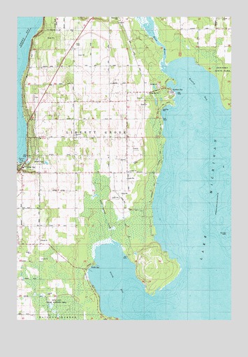
Sister Bay, WI USGS Topographic Map
Click on map above to begin viewing in our Map Viewer.

This topographic map contains these locations and features:
Feature Name Type Latitude Longitude GNIS ID View Map
A A Ranch of WisconsinLocaleN45.2033°W87.0978°2711342View Map
Appleport SchoolSchoolN45.1858°W87.0890°1560913View Map
Door County Library Sister Bay - Liberty Grove BranchBuildingN45.1878°W87.1206°2711360View Map
Ellison Bay CemeteryCemeteryN45.2497°W87.0660°1577940View Map
Fierce FarmsLocaleN45.1692°W87.0961°2711340View Map
Four Foot ShoalBarN45.1608°W87.0021°1565184View Map
Hill Road Airport (historical)AirportN45.2042°W87.0987°1582210View Map
Hill's OrchardLocaleN45.1911°W87.0992°2711261View Map
Liberty Grove CemeteryCemeteryN45.2494°W87.0643°1568014View Map
Marshall's Point State Natural AreaParkN45.1450°W87.0344°2085425View Map
Mave's Lakeview Road AirportAirportN45.2345°W87.0670°2444203View Map
Mink RiverStreamN45.2292°W87.0384°1569563View Map
Mink River Estuary State Natural AreaParkN45.2353°W87.0389°2085426View Map
Moravain ChurchChurchN45.2019°W87.0915°1577935View Map
North BayBayN45.1358°W87.0601°1570352View Map
North BayPopulated PlaceN45.1461°W87.0829°1570354View Map
North Bay Road FarmsLocaleN45.1839°W87.0669°2711341View Map
North Bay State Natural AreaParkN45.1564°W87.0825°2085430View Map
Rowley BayBayN45.2180°W87.0198°1572690View Map
Rowleys BayPopulated PlaceN45.2197°W87.0354°1572692View Map
Rowleys Bay CemeteryCemeteryN45.2193°W87.0481°1577941View Map
Sand BayBayN45.2078°W87.0371°1577942View Map
Sand Bay ParkParkN45.2114°W87.0412°1573654View Map
Seaquist OrchardsLocaleN45.2267°W87.1014°2711259View Map
Sister BayBayN45.1922°W87.1207°1574208View Map
Sister BayPopulated PlaceN45.1872°W87.1209°1574209View Map
Sister Bay Liberty Grove Fire Department South StationBuildingN45.1878°W87.1163°2698047View Map
Sister Bay Post OfficePost OfficeN45.1894°W87.1211°2711343View Map
Three Springs CreekStreamN45.1578°W87.0690°1577936View Map
Wildwood FarmLocaleN45.2136°W87.0781°2711339View Map
Wildwood SchoolSchoolN45.2125°W87.0912°1576752View Map
Zoo LakeLakeN45.1766°W87.0794°2761480View Map

Note: Coordinates in the location and feature list above are referenced to NAD83 datum.


Copyright (C) 2008-2025 Ryan Niemi / Sunset Dynamics ... All Rights Reserved