TopoQuest Logo
Do you find TopoQuest useful?
Help keep TopoQuest running and adding new maps/features by donating!
Bitcoin:  19c7KJd3qBynnjoSw5npx9KScwjBe4ifkT
Litecoin:  LXs6TkuXGGXo1vDsWCkWVdjQX94eUKd6ui
Home View Maps Find Maps Find Places Resources & Links


Sleeping Giant, Alabama Topographic Map

USGS Map Title: Sleeping Giant, AL
USGS Map MRC: 33086D2
DRG (GeoTIFF) Download: o33086d2.tif


Neighboring USGS Topographic Map Quads:


  Pell City, AL  
33086E3
 

  Riverside, AL  
33086E2
 

  Eastaboga, AL  
33086E1
 

  Laniers, AL  
33086D3
 

  Sleeping Giant, AL  
33086D2
 

  Talladega, AL  
33086D1
 

  Childersburg, AL  
33086C3
 

  Winterboro, AL  
33086C2
 

  Porter Gap, AL  
33086C1


Map MRC Location:

N34°
W87°
N34°
W86°
H8 H7 H6 H5 H4 H3 H2 H1
G8 G7 G6 G5 G4 G3 G2 G1
F8 F7 F6 F5 F4 F3 F2 F1
E8 E7 E6 E5 E4 E3 E2 E1
D8 D7 D6 D5 D4 D3 D2 D1
C8 C7 C6 C5 C4 C3 C2 C1
B8 B7 B6 B5 B4 B3 B2 B1
A8 A7 A6 A5 A4 A3 A2 A1
N33°
W87°
N33°
W86°

Sleeping Giant, AL USGS 1:24K Topographic Map Preview:
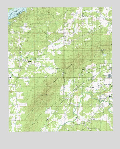
Sleeping Giant, AL USGS Topographic Map
Click on map above to begin viewing in our Map Viewer.

This topographic map contains these locations and features:
Feature Name Type Latitude Longitude GNIS ID View Map
Allen-Sims CemeteryCemeteryN33.4340°W86.1952°141240View Map
Antioch ChurchChurchN33.4557°W86.2375°113158View Map
Antioch School (historical)SchoolN33.4551°W86.2355°144713View Map
Armbrester CemeteryCemeteryN33.3857°W86.1964°144714View Map
Atkinsons Mill (historical)LocaleN33.3890°W86.1672°144716View Map
BarclayPopulated PlaceN33.4193°W86.1669°156022View Map
Barclay BranchStreamN33.4134°W86.1619°113465View Map
BethelPopulated PlaceN33.4912°W86.1328°144721View Map
Bethel Methodist ChurchChurchN33.4909°W86.1333°144722View Map
Bethel School (historical)SchoolN33.4904°W86.1333°144724View Map
Binghams BranchStreamN33.4190°W86.1616°162398View Map
Bucky PeakSummitN33.3798°W86.1825°144739View Map
Cast HillSummitN33.4446°W86.2241°144751View Map
Chapple BranchStreamN33.4967°W86.1539°141118View Map
Clifton Plantation (historical)LocaleN33.3832°W86.2344°144773View Map
Cole ChurchChurchN33.4934°W86.1611°116405View Map
Collins BendBendN33.4987°W86.2333°116438View Map
Concord Methodist ChurchChurchN33.4393°W86.1911°144778View Map
Cooks Junction (historical)LocaleN33.4340°W86.1833°144780View Map
Coxs PondLakeN33.4287°W86.1430°144785View Map
Curry IslandIslandN33.4915°W86.2469°116979View Map
Dark HollowValleyN33.3909°W86.2280°117077View Map
Fair ParkPopulated PlaceN33.4259°W86.1825°144808View Map
Fair Park Baptist ChurchChurchN33.4362°W86.1597°144809View Map
Federal Correctional Institution TalladegaBuildingN33.4214°W86.1406°145004View Map
FishtrapPopulated PlaceN33.4904°W86.2405°156350View Map
Flagpole MountainSummitN33.4115°W86.2075°118351View Map
Ford of Talladega Creek (historical)CrossingN33.4051°W86.1339°144823View Map
Freeze CemeteryCemeteryN33.4454°W86.2258°144829View Map
Freeze Mill (historical)LocaleN33.4334°W86.1930°144830View Map
Goray SpringSpringN33.4940°W86.1397°144836View Map
Grogans SpringSpringN33.3843°W86.1597°144842View Map
Harrison Switch (historical)LocaleN33.4265°W86.2380°144844View Map
HepzibahPopulated PlaceN33.4471°W86.2316°119991View Map
Hepzibah Baptist ChurchChurchN33.4479°W86.2369°144848View Map
Hepzibah CemeteryCemeteryN33.4468°W86.2369°1805472View Map
Hillsman GapGapN33.4287°W86.1839°144850View Map
Hillsville (historical)LocaleN33.4279°W86.2278°144851View Map
Howard ChapelChurchN33.4662°W86.1794°120473View Map
Howells CovePopulated PlaceN33.4921°W86.1600°144855View Map
Hustons Crossroads (historical)LocaleN33.4934°W86.1614°158160View Map
Ida Academy (historical)SchoolN33.4896°W86.1397°144858View Map
Island Park (historical)ParkN33.4057°W86.1653°144860View Map
Island Park SpringSpringN33.4057°W86.1653°144861View Map
Jones View SchoolSchoolN33.4448°W86.2244°151919View Map
JonesviewPopulated PlaceN33.4423°W86.2239°144864View Map
Jumpers Spring BranchStreamN33.3896°W86.1675°144867View Map
Kyser Leonard Lakefront EstatesPopulated PlaceN33.4898°W86.2439°144878View Map
Lake JoyReservoirN33.4758°W86.1308°144866View Map
Lawson HillSummitN33.4621°W86.1280°159918View Map
LedbetterPopulated PlaceN33.3848°W86.2408°144881View Map
Lokey (historical)LocaleN33.4390°W86.1444°144888View Map
MardisvillePopulated PlaceN33.3846°W86.1591°166157View Map
Mardisville CemeteryCemeteryN33.3829°W86.1555°144895View Map
Mardisville Post OfficePost OfficeN33.3846°W86.1591°169281View Map
Mardisville SchoolSchoolN33.3829°W86.1594°122278View Map
Midway Memorial GardensCemeteryN33.3876°W86.1500°144901View Map
Miles QuarryMineN33.4082°W86.1661°144905View Map
Moxley (historical)LocaleN33.4643°W86.1980°144917View Map
Mullins BranchStreamN33.4226°W86.1730°144918View Map
Murphy (historical)LocaleN33.4084°W86.1319°144919View Map
Pruitts SpringSpringN33.4218°W86.1783°144944View Map
Redville (historical)LocaleN33.4498°W86.1361°144949View Map
RenfroePopulated PlaceN33.4312°W86.2016°153136View Map
Renfroe ChurchChurchN33.4376°W86.1922°125563View Map
Renfroe Lookout TowerTowerN33.4115°W86.2078°144951View Map
Renfroe MountainSummitN33.4229°W86.1989°144952View Map
Renfroe Volunteer Fire Department Station 2BuildingN33.4439°W86.2239°2682911View Map
Rocky HollowValleyN33.4387°W86.1394°125860View Map
Shocco MountainSummitN33.4618°W86.1308°144978View Map
Shocco SpringsPopulated PlaceN33.4557°W86.1380°126973View Map
Shocco SpringsPopulated PlaceN33.4534°W86.1375°144979View Map
Shocco Station (historical)LocaleN33.4396°W86.1361°144980View Map
Sleeping GiantRidgeN33.4284°W86.1869°153468View Map
Talladega AcademySchoolN33.4196°W86.1503°144999View Map
Talladega CountyCivilN33.3801°W86.1659°161586View Map
Talladega County Sheriff's OfficeBuildingN33.4245°W86.1411°2751717View Map
Talladega County Training SchoolSchoolN33.4918°W86.1600°145002View Map
Talladega Creek Baptist ChurchChurchN33.4076°W86.1444°145003View Map
Talladega Recreational ComplexParkN33.4182°W86.1522°145006View Map
Tatertown (historical)LocaleN33.4387°W86.1466°145011View Map
ThornhillPopulated PlaceN33.4001°W86.1405°145014View Map
Thornhill CemeteryCemeteryN33.4012°W86.1427°145015View Map
Town CreekStreamN33.4143°W86.1522°160750View Map
TucktownPopulated PlaceN33.4632°W86.1569°145022View Map
Union School (historical)SchoolN33.4229°W86.2408°145024View Map
Wesley Chapel Methodist ChurchChurchN33.4915°W86.1603°145029View Map
WHTB-FM (Talladega)TowerN33.4118°W86.2055°161182View Map
Wolf PondLakeN33.4843°W86.1911°129171View Map

Note: Coordinates in the location and feature list above are referenced to NAD83 datum.


Copyright (C) 2008-2025 Ryan Niemi / Sunset Dynamics ... All Rights Reserved