TopoQuest Logo
Do you find TopoQuest useful?
Help keep TopoQuest running and adding new maps/features by donating!
Bitcoin:  19c7KJd3qBynnjoSw5npx9KScwjBe4ifkT
Litecoin:  LXs6TkuXGGXo1vDsWCkWVdjQX94eUKd6ui
Home View Maps Find Maps Find Places Resources & Links


Winterboro, Alabama Topographic Map

USGS Map Title: Winterboro, AL
USGS Map MRC: 33086C2
DRG (GeoTIFF) Download: o33086c2.tif


Neighboring USGS Topographic Map Quads:


  Laniers, AL  
33086D3
 

  Sleeping Giant, AL  
33086D2
 

  Talladega, AL  
33086D1
 

  Childersburg, AL  
33086C3
 

  Winterboro, AL  
33086C2
 

  Porter Gap, AL  
33086C1
 

  Sylacauga West, AL  
33086B3
 

  Sylacauga East, AL  
33086B2
 

  Bulls Gap, AL  
33086B1


Map MRC Location:

N34°
W87°
N34°
W86°
H8 H7 H6 H5 H4 H3 H2 H1
G8 G7 G6 G5 G4 G3 G2 G1
F8 F7 F6 F5 F4 F3 F2 F1
E8 E7 E6 E5 E4 E3 E2 E1
D8 D7 D6 D5 D4 D3 D2 D1
C8 C7 C6 C5 C4 C3 C2 C1
B8 B7 B6 B5 B4 B3 B2 B1
A8 A7 A6 A5 A4 A3 A2 A1
N33°
W87°
N33°
W86°

Winterboro, AL USGS 1:24K Topographic Map Preview:
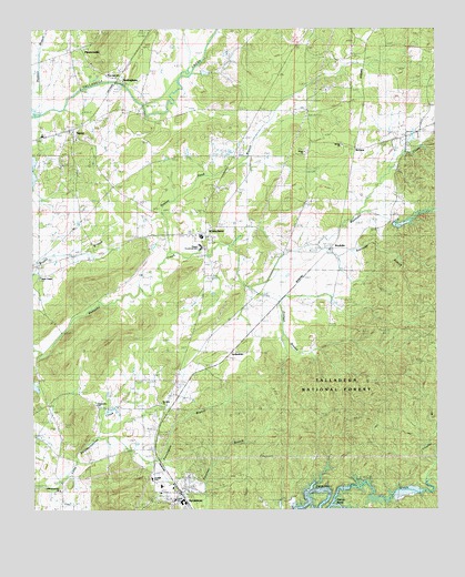
Winterboro, AL USGS Topographic Map
Click on map above to begin viewing in our Map Viewer.

This topographic map contains these locations and features:
Feature Name Type Latitude Longitude GNIS ID View Map
Abihka (historical)Populated PlaceN33.3001°W86.1611°158185View Map
Adairs (historical)LocaleN33.2709°W86.2111°144704View Map
Africa ChurchChurchN33.3429°W86.1653°112939View Map
AlpinePopulated PlaceN33.3487°W86.2386°113045View Map
Alpine Baptist ChurchChurchN33.3465°W86.2361°144709View Map
Alpine Post OfficePost OfficeN33.3484°W86.2381°2788926View Map
Andeluvia MountainSummitN33.2512°W86.2261°144712View Map
Arizola (historical)LocaleN33.3232°W86.1547°144715View Map
Autreys (historical)LocaleN33.3421°W86.1811°144717View Map
Baker BranchStreamN33.2507°W86.1566°113372View Map
Berney Station Volunteer Fire DepartmentBuildingN33.3497°W86.1274°2683377View Map
BerneysPopulated PlaceN33.3437°W86.1494°156053View Map
Bowies QuarryMineN33.2948°W86.1569°158154View Map
Carletons Station (historical)LocaleN33.3687°W86.1625°144749View Map
Charles BranchStreamN33.2615°W86.1252°115970View Map
Darby SpringSpringN33.3151°W86.1833°144790View Map
Glovers (historical)LocaleN33.3290°W86.1533°144833View Map
Greasy Head BranchStreamN33.3168°W86.2075°119314View Map
Greasy Head SwampSwampN33.3273°W86.2091°144837View Map
Hammond (historical)LocaleN33.2515°W86.1389°144843View Map
Heacock MountainSummitN33.2909°W86.2283°144846View Map
Jack MountainSummitN33.2882°W86.1769°144862View Map
Kellys LakeReservoirN33.3242°W86.1356°131433View Map
Killough DamDamN33.3384°W86.2500°131456View Map
KingstonPopulated PlaceN33.3668°W86.2319°144873View Map
Kingston Baptist ChurchChurchN33.3659°W86.2316°144874View Map
Kingston CemeteryCemeteryN33.3654°W86.2316°1805531View Map
Kingston Plantation (historical)LocaleN33.3382°W86.2480°144875View Map
Lawler Place Plantation (historical)LocaleN33.3548°W86.1650°144880View Map
LedbettersPopulated PlaceN33.2909°W86.1880°156593View Map
Linder SchoolSchoolN33.2529°W86.2061°144885View Map
Mallory MountainSummitN33.3084°W86.2366°144891View Map
Mount Ida Baptist ChurchChurchN33.3451°W86.1539°144909View Map
Mount Ida Plantation (historical)LocaleN33.3218°W86.1708°144910View Map
Mount Olive Baptist ChurchChurchN33.2776°W86.2103°152463View Map
Mountain Home ChurchChurchN33.2590°W86.2022°144916View Map
New Light Methodist ChurchChurchN33.3634°W86.2289°144920View Map
New Light School (historical)SchoolN33.3634°W86.2291°144921View Map
New Maryland Baptist ChurchChurchN33.3421°W86.2411°152660View Map
NottinghamPopulated PlaceN33.3623°W86.2228°156807View Map
Oxbow BendBendN33.2509°W86.1594°124361View Map
PapertownPopulated PlaceN33.2768°W86.2291°144928View Map
Papertown ChurchChurchN33.2773°W86.2305°144929View Map
Pennington BranchStreamN33.2684°W86.2308°124589View Map
Pine Hill SchoolSchoolN33.3323°W86.1930°124819View Map
Pittard Vocational SchoolSchoolN33.3182°W86.1980°144933View Map
PlantersvillePopulated PlaceN33.3698°W86.2358°124929View Map
Pridgen BranchStreamN33.3073°W86.1830°153064View Map
RendaliaPopulated PlaceN33.3176°W86.1572°156955View Map
Rendalia Water FallsFallsN33.3015°W86.1714°144950View Map
ReubenvillePopulated PlaceN33.3696°W86.2380°144953View Map
Reynolds BranchStreamN33.3090°W86.1772°153138View Map
Reynolds MillPopulated PlaceN33.3554°W86.2158°156958View Map
Riser ChapelChurchN33.3101°W86.2475°153156View Map
Riser DamDamN33.2818°W86.2500°131380View Map
Riser LakeReservoirN33.2821°W86.2494°131381View Map
RisersPopulated PlaceN33.2959°W86.2403°158166View Map
Swept CreekStreamN33.2557°W86.1283°127598View Map
SycamorePopulated PlaceN33.2512°W86.2025°127608View Map
Sycamore Baptist ChurchChurchN33.2546°W86.2108°144988View Map
Sycamore Junior High SchoolSchoolN33.2579°W86.2133°144989View Map
Sycamore Post OfficePost OfficeN33.2543°W86.2045°2789001View Map
Sycamore Volunteer Fire DepartmentBuildingN33.2547°W86.2050°2682889View Map
Sycamore-Winterboro DivisionCivilN33.3012°W86.1817°165963View Map
TallaseehatcheePopulated PlaceN33.2668°W86.2416°145008View Map
Tallaseehatchee ChurchChurchN33.2546°W86.2414°127644View Map
Trinity Episcopal ChurchChurchN33.3509°W86.2344°145018View Map
Wewoka Camp Ground (historical)LocaleN33.3140°W86.1847°145032View Map
Wewoka Junction (historical)LocaleN33.2973°W86.1811°145033View Map
Wilson CemeteryCemeteryN33.3087°W86.1839°145036View Map
WinterboroPopulated PlaceN33.3215°W86.1969°129128View Map
Winterboro Baptist ChurchChurchN33.3226°W86.1989°145037View Map
Winterboro High SchoolSchoolN33.3209°W86.1972°145038View Map
Winterboro Volunteer Fire and RescueBuildingN33.3417°W86.1881°2682899View Map

Note: Coordinates in the location and feature list above are referenced to NAD83 datum.


Copyright (C) 2008-2024 Ryan Niemi / Sunset Dynamics ... All Rights Reserved