TopoQuest Logo
Do you find TopoQuest useful?
Help keep TopoQuest running and adding new maps/features by donating!
Bitcoin:  19c7KJd3qBynnjoSw5npx9KScwjBe4ifkT
Litecoin:  LXs6TkuXGGXo1vDsWCkWVdjQX94eUKd6ui
Home View Maps Find Maps Find Places Resources & Links


Slide Mountain, Oregon Topographic Map

USGS Map Title: Slide Mountain, OR
USGS Map MRC: 42120F6
DRG (GeoTIFF) Download: o42120f6.tif


Neighboring USGS Topographic Map Quads:


  Fremont Point, OR  
42120G7
 

  South of Ana River, OR  
42120G6
 

  Loco Lake, OR  
42120G5
 

  Harvey Creek, OR  
42120F7
 

  Slide Mountain, OR  
42120F6
 

  Paisley, OR  
42120F5
 

  Lee Thomas Crossing, OR  
42120E7
 

  Coffeepot Creek, OR  
42120E6
 

  Morgan Butte, OR  
42120E5


Map MRC Location:

N43°
W121°
N43°
W120°
H8 H7 H6 H5 H4 H3 H2 H1
G8 G7 G6 G5 G4 G3 G2 G1
F8 F7 F6 F5 F4 F3 F2 F1
E8 E7 E6 E5 E4 E3 E2 E1
D8 D7 D6 D5 D4 D3 D2 D1
C8 C7 C6 C5 C4 C3 C2 C1
B8 B7 B6 B5 B4 B3 B2 B1
A8 A7 A6 A5 A4 A3 A2 A1
N42°
W121°
N42°
W120°

Slide Mountain, OR USGS 1:24K Topographic Map Preview:
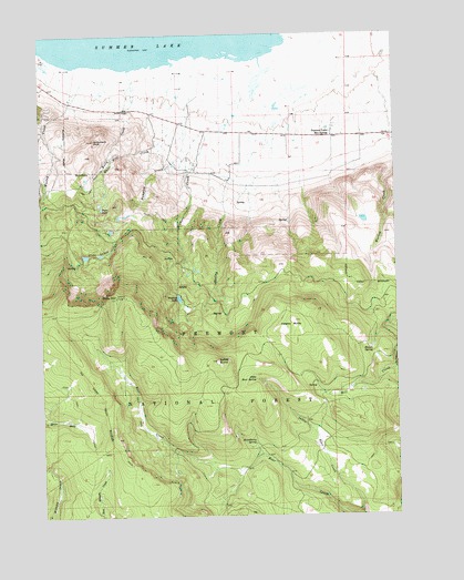
Slide Mountain, OR USGS Topographic Map
Click on map above to begin viewing in our Map Viewer.

This topographic map contains these locations and features:
Feature Name Type Latitude Longitude GNIS ID View Map
Bear Creek TrailheadLocaleN42.6419°W120.7047°2548758View Map
Blue LakeLakeN42.6992°W120.7262°1153794View Map
Gibson Hot SpringSpringN42.7290°W120.6822°1153793View Map
Hadley ButteSummitN42.6754°W120.6622°1143189View Map
Hadley Butte Launch AreaLocaleN42.6899°W120.6666°1952925View Map
Hadley CreekStreamN42.7040°W120.6969°1143190View Map
Hampton CreekStreamN42.7318°W120.6989°1156664View Map
Hanan SpringSpringN42.6679°W120.6348°1143257View Map
Hanan TrailTrailN42.6371°W120.7197°1143258View Map
Harvey RanchLocaleN42.7324°W120.7350°1155791View Map
J V Withers RanchLocaleN42.7157°W120.6844°1155792View Map
Kelly CreekStreamN42.7407°W120.7194°1144524View Map
Little Bear SpringSpringN42.6604°W120.6760°1145092View Map
Monument RockPillarN42.7224°W120.7322°1146405View Map
Potts LakeReservoirN42.7048°W120.7295°1147950View Map
Sandy ButteSummitN42.6652°W120.6894°1149055View Map
Slide Lake Recreation SiteLocaleN42.6929°W120.7286°1952936View Map
Slide LakesLakeN42.6925°W120.7354°1161519View Map
Slide MountainSummitN42.6815°W120.7247°1149716View Map
Slide Mountain Geological AreaReserveN42.6888°W120.7178°1161630View Map
Slide Mountain Lookout TowerTowerN42.6818°W120.7414°1160903View Map
Strawberry SpringSpringN42.6444°W120.6766°1150487View Map
Summer Lake Hot SpringLocaleN42.7254°W120.6475°1150597View Map
Summer Lake Hot SpringsSpringN42.7256°W120.6473°1153792View Map
White Hill CreekStreamN42.7318°W120.6989°1152233View Map
Whitehill Post Office (historical)Post OfficeN42.7249°W120.6928°1166170View Map
Withers CreekStreamN42.7438°W120.6739°1152560View Map
Withers DamDamN42.6825°W120.7030°1155679View Map
Withers LakeReservoirN42.6815°W120.7026°1152561View Map
Withers Lake Recreation SiteLocaleN42.6815°W120.7019°1952943View Map
Woodward Reservoir Number OneReservoirN42.7086°W120.6773°1153791View Map
Woodward Reservoir Number TwoReservoirN42.7095°W120.6749°1153790View Map
Worlow CreekStreamN42.7218°W120.6261°1152651View Map

Note: Coordinates in the location and feature list above are referenced to NAD83 datum.


Copyright (C) 2008-2025 Ryan Niemi / Sunset Dynamics ... All Rights Reserved