TopoQuest Logo
Do you find TopoQuest useful?
Help keep TopoQuest running and adding new maps/features by donating!
Bitcoin:  19c7KJd3qBynnjoSw5npx9KScwjBe4ifkT
Litecoin:  LXs6TkuXGGXo1vDsWCkWVdjQX94eUKd6ui
Home View Maps Find Maps Find Places Resources & Links


Smackover, Arkansas Topographic Map

USGS Map Title: Smackover, AR
USGS Map MRC: 33092C6
DRG (GeoTIFF) Download: o33092c6.tif


Neighboring USGS Topographic Map Quads:


  Louann, AR  
33092D7
 

  Snow Hill, AR  
33092D6
 

  Smackover NE, AR  
33092D5
 

  Lisbon, AR  
33092C7
 

  Smackover, AR  
33092C6
 

  Calion, AR  
33092C5
 

  Newell, AR  
33092B7
 

  El Dorado West, AR  
33092B6
 

  El Dorado East, AR  
33092B5


Map MRC Location:

N34°
W93°
N34°
W92°
H8 H7 H6 H5 H4 H3 H2 H1
G8 G7 G6 G5 G4 G3 G2 G1
F8 F7 F6 F5 F4 F3 F2 F1
E8 E7 E6 E5 E4 E3 E2 E1
D8 D7 D6 D5 D4 D3 D2 D1
C8 C7 C6 C5 C4 C3 C2 C1
B8 B7 B6 B5 B4 B3 B2 B1
A8 A7 A6 A5 A4 A3 A2 A1
N33°
W93°
N33°
W92°

Smackover, AR USGS 1:24K Topographic Map Preview:
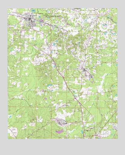
Smackover, AR USGS Topographic Map
Click on map above to begin viewing in our Map Viewer.

This topographic map contains these locations and features:
Feature Name Type Latitude Longitude GNIS ID View Map
City of NorphletCivilN33.3200°W92.6622°2404387View Map
City of SmackoverCivilN33.3640°W92.7312°2405472View Map
Ebenezer Baptist ChurchChurchN33.2546°W92.7238°76844View Map
Ebenezer CemeteryCemeteryN33.2523°W92.7170°76843View Map
First Baptist ChurchChurchN33.3648°W92.7265°59665View Map
Hicks CemeteryCemeteryN33.3415°W92.6683°77180View Map
Holmes CreekStreamN33.3615°W92.6818°50260View Map
Ingram - Reeves CemeteryCemeteryN33.2531°W92.6573°60938View Map
KAYZ-FM (El Dorado)TowerN33.2721°W92.7035°85386View Map
KBSA-FM (El Dorado)TowerN33.2721°W92.7035°85385View Map
KenovaPopulated PlaceN33.3573°W92.6974°58013View Map
KIXK-FM (El Dorado)TowerN33.2726°W92.6571°85383View Map
Missionary ChurchChurchN33.3223°W92.6996°52098View Map
Mount Zion ChurchChurchN33.3171°W92.6696°52454View Map
New Providence ChurchChurchN33.3187°W92.6943°52731View Map
NorphletPopulated PlaceN33.3160°W92.6629°58272View Map
Norphlet CemeteryCemeteryN33.3093°W92.6639°60951View Map
Norphlet Elementary SchoolSchoolN33.3105°W92.6598°59770View Map
Norphlet High SchoolSchoolN33.3106°W92.6611°81909View Map
Norphlet Police DepartmentBuildingN33.3157°W92.6631°2118896View Map
Norphlet Post OfficePost OfficeN33.3150°W92.6629°84825View Map
Norphlet Volunteer Fire StationBuildingN33.3161°W92.6627°2116860View Map
Northside ChapelChurchN33.2587°W92.6579°52845View Map
Old Harmony ChurchChurchN33.3226°W92.6832°52999View Map
Ozark Ordnance Works (historical)MilitaryN33.2658°W92.6878°2106683View Map
Primm CemeteryCemeteryN33.3385°W92.6940°60955View Map
Rehobeth CemeteryCemeteryN33.2857°W92.6810°59812View Map
Rehobeth Primitive Baptist ChurchChurchN33.2848°W92.6807°78159View Map
Rest Haven Memorial GardensCemeteryN33.2812°W92.6860°78167View Map
Samckover Branch Union County LibraryBuildingN33.3646°W92.7254°59838View Map
Samckover CemeteryCemeteryN33.3548°W92.7257°59840View Map
Sandy LandPopulated PlaceN33.3348°W92.7013°58586View Map
SmackoverPopulated PlaceN33.3648°W92.7249°58637View Map
Smackover Elementary SchoolSchoolN33.3654°W92.7294°59841View Map
Smackover First United Methodist ChurchChurchN33.3668°W92.7307°59839View Map
Smackover High SchoolSchoolN33.3659°W92.7311°59842View Map
Smackover Police DepartmentBuildingN33.3642°W92.7235°2118901View Map
Smackover Training SchoolSchoolN33.3526°W92.7357°54924View Map
Smackover Volunteer Fire StationBuildingN33.3641°W92.7234°2117130View Map
Smith SchoolSchoolN33.3190°W92.6807°54959View Map
Standard UmpsteadPopulated PlaceN33.3732°W92.6749°55149View Map
Standard Umpstead School (historical)SchoolN33.3740°W92.6735°64410View Map
Standard Volunteer Fire DepartmentBuildingN33.3743°W92.6779°2117170View Map
Sycamore Grove CemeteryCemeteryN33.2954°W92.6329°59865View Map
Sycamore Grove Church of ChristChurchN33.2954°W92.6329°78516View Map
Township of NorphletCivilN33.3194°W92.6460°69753View Map
Township of SmackoverCivilN33.3386°W92.7428°69754View Map

Note: Coordinates in the location and feature list above are referenced to NAD83 datum.


Copyright (C) 2008-2025 Ryan Niemi / Sunset Dynamics ... All Rights Reserved