TopoQuest Logo
Do you find TopoQuest useful?
Help keep TopoQuest running and adding new maps/features by donating!
Bitcoin:  19c7KJd3qBynnjoSw5npx9KScwjBe4ifkT
Litecoin:  LXs6TkuXGGXo1vDsWCkWVdjQX94eUKd6ui
Home View Maps Find Maps Find Places Resources & Links


Louann, Arkansas Topographic Map

USGS Map Title: Louann, AR
USGS Map MRC: 33092D7
DRG (GeoTIFF) Download: o33092d7.tif


Neighboring USGS Topographic Map Quads:


  Camden SW, AR  
33092E8
 

  Camden, AR  
33092E7
 

  East Camden, AR  
33092E6
 

  Buena Vista, AR  
33092D8
 

  Louann, AR  
33092D7
 

  Snow Hill, AR  
33092D6
 

  Mount Holly, AR  
33092C8
 

  Lisbon, AR  
33092C7
 

  Smackover, AR  
33092C6


Map MRC Location:

N34°
W93°
N34°
W92°
H8 H7 H6 H5 H4 H3 H2 H1
G8 G7 G6 G5 G4 G3 G2 G1
F8 F7 F6 F5 F4 F3 F2 F1
E8 E7 E6 E5 E4 E3 E2 E1
D8 D7 D6 D5 D4 D3 D2 D1
C8 C7 C6 C5 C4 C3 C2 C1
B8 B7 B6 B5 B4 B3 B2 B1
A8 A7 A6 A5 A4 A3 A2 A1
N33°
W93°
N33°
W92°

Louann, AR USGS 1:24K Topographic Map Preview:
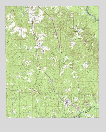
Louann, AR USGS Topographic Map
Click on map above to begin viewing in our Map Viewer.

This topographic map contains these locations and features:
Feature Name Type Latitude Longitude GNIS ID View Map
Bethesda Cumberland ChurchChurchN33.4926°W92.8643°76321View Map
Calvary ChurchChurchN33.4293°W92.8271°47296View Map
Doris CreekStreamN33.4876°W92.7563°48568View Map
East Pace City Oil and Gas FieldOilfieldN33.3954°W92.8635°48771View Map
Ebenezer CemeteryCemeteryN33.4015°W92.7724°48795View Map
Ebenezer ChurchChurchN33.4018°W92.7760°48802View Map
ElliottPopulated PlaceN33.4573°W92.8279°57713View Map
Elliott Baptist ChurchChurchN33.4607°W92.8302°64375View Map
Elliott Volunteer Fire Department StationBuildingN33.4577°W92.8285°2116402View Map
FrenchportPopulated PlaceN33.4712°W92.7779°76979View Map
Frenchport ChurchChurchN33.4640°W92.7735°49246View Map
Frenchport LandingLocaleN33.4835°W92.7541°57774View Map
Frenchport Volunteer Fire DepartmentBuildingN33.4674°W92.7801°2116462View Map
Good Home ChurchChurchN33.4312°W92.7877°49490View Map
Hughes CemeteryCemeteryN33.3976°W92.7629°50397View Map
Jones CemeteryCemeteryN33.4385°W92.7971°50715View Map
KirklandPopulated PlaceN33.4154°W92.8138°50883View Map
LibertyPopulated PlaceN33.4046°W92.8366°58066View Map
LouannPopulated PlaceN33.3910°W92.7918°58090View Map
Louann Baptist ChurchChurchN33.3918°W92.7938°64397View Map
Louann Volunteer Fire DepartmentBuildingN33.3920°W92.7920°2116744View Map
Mount Horeb CemeteryCemeteryN33.4708°W92.8007°52305View Map
Mount Pisgah CemeteryCemeteryN33.4415°W92.7510°52374View Map
New Jerusalem ChurchChurchN33.4415°W92.8554°52707View Map
Old Liberty CemeteryCemeteryN33.4990°W92.8465°53005View Map
Patton CemeteryCemeteryN33.4973°W92.8089°53226View Map
Pine Log CreekStreamN33.4173°W92.8307°53455View Map
Sylvan Hills Baptist ChurchChurchN33.4979°W92.8391°78518View Map
Town of LouannCivilN33.3916°W92.7921°2406044View Map
Township of Bridge CreekCivilN33.4160°W92.8682°68913View Map
Wolf CreekStreamN33.3807°W92.7732°56479View Map

Note: Coordinates in the location and feature list above are referenced to NAD83 datum.


Copyright (C) 2008-2025 Ryan Niemi / Sunset Dynamics ... All Rights Reserved