TopoQuest Logo
Do you find TopoQuest useful?
Help keep TopoQuest running and adding new maps/features by donating!
Bitcoin:  19c7KJd3qBynnjoSw5npx9KScwjBe4ifkT
Litecoin:  LXs6TkuXGGXo1vDsWCkWVdjQX94eUKd6ui
Home View Maps Find Maps Find Places Resources & Links


Newell, Arkansas Topographic Map

USGS Map Title: Newell, AR
USGS Map MRC: 33092B7
DRG (GeoTIFF) Download: o33092b7.tif


Neighboring USGS Topographic Map Quads:


  Mount Holly, AR  
33092C8
 

  Lisbon, AR  
33092C7
 

  Smackover, AR  
33092C6
 

  Marysville, AR  
33092B8
 

  Newell, AR  
33092B7
 

  El Dorado West, AR  
33092B6
 

  Wesson SW, AR  
33092A8
 

  Wesson, AR  
33092A7
 

  Junction City, AR  
33092A6


Map MRC Location:

N34°
W93°
N34°
W92°
H8 H7 H6 H5 H4 H3 H2 H1
G8 G7 G6 G5 G4 G3 G2 G1
F8 F7 F6 F5 F4 F3 F2 F1
E8 E7 E6 E5 E4 E3 E2 E1
D8 D7 D6 D5 D4 D3 D2 D1
C8 C7 C6 C5 C4 C3 C2 C1
B8 B7 B6 B5 B4 B3 B2 B1
A8 A7 A6 A5 A4 A3 A2 A1
N33°
W93°
N33°
W92°

Newell, AR USGS 1:24K Topographic Map Preview:
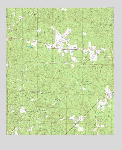
Newell, AR USGS Topographic Map
Click on map above to begin viewing in our Map Viewer.

This topographic map contains these locations and features:
Feature Name Type Latitude Longitude GNIS ID View Map
Burns PondReservoirN33.2113°W92.8484°75666View Map
CairoPopulated PlaceN33.2201°W92.8699°56946View Map
Cairo Oil and Gas FieldOilfieldN33.1851°W92.8538°85270View Map
Cairo Volunteer Fire StationBuildingN33.2251°W92.8691°2116214View Map
Carroll CemeteryCemeteryN33.1723°W92.8035°60918View Map
Curtis CreekStreamN33.1321°W92.7857°48273View Map
Curtis Grove CemeteryCemeteryN33.1371°W92.8343°48274View Map
East Shuler Oil and Gas FieldOilfieldN33.1474°W92.8385°48777View Map
Fast Ambulance ServiceBuildingN33.2148°W92.8122°2119021View Map
Friendship CemeteryCemeteryN33.1982°W92.8718°59685View Map
Friendship Methodist ChurchChurchN33.1982°W92.8724°76981View Map
Goodwin CemeteryCemeteryN33.2274°W92.7588°49504View Map
Goodwin Field ChurchChurchN33.2099°W92.8177°49506View Map
GriffinPopulated PlaceN33.1368°W92.7715°59697View Map
Harris CemeteryCemeteryN33.1965°W92.8032°49892View Map
Hopewell Baptist ChurchChurchN33.1449°W92.8618°77214View Map
Hopewell CemeteryCemeteryN33.1440°W92.8621°59707View Map
Jay Dison Spring BranchStreamN33.1585°W92.7788°50596View Map
Landmark ChurchChurchN33.1465°W92.8613°50975View Map
Lisbon Oil and Gas FieldOilfieldN33.2379°W92.7518°51180View Map
Mount Renia CemeteryCemeteryN33.1837°W92.8646°77741View Map
Mount Willie CemeteryCemeteryN33.1493°W92.8343°59758View Map
Mount Willie ChurchChurchN33.1493°W92.8352°52435View Map
Mount Zion CemeteryCemeteryN33.2437°W92.8396°59756View Map
Mount Zion ChurchChurchN33.2426°W92.8407°52452View Map
Pate CemeteryCemeteryN33.2157°W92.7890°53211View Map
Shuler Oil and Gas FieldOilfieldN33.1526°W92.8749°54833View Map
South Arkansas Regional Airport at Goodwin FieldAirportN33.2176°W92.8107°83689View Map
Township of WessonCivilN33.1256°W92.7853°69757View Map
TrullPopulated PlaceN33.1476°W92.8354°59871View Map

Note: Coordinates in the location and feature list above are referenced to NAD83 datum.


Copyright (C) 2008-2025 Ryan Niemi / Sunset Dynamics ... All Rights Reserved