TopoQuest Logo
Do you find TopoQuest useful?
Help keep TopoQuest running and adding new maps/features by donating!
Bitcoin:  19c7KJd3qBynnjoSw5npx9KScwjBe4ifkT
Litecoin:  LXs6TkuXGGXo1vDsWCkWVdjQX94eUKd6ui
Home View Maps Find Maps Find Places Resources & Links


Small Point, Maine Topographic Map

USGS Map Title: Small Point, ME
USGS Map MRC: 43069F7
DRG (GeoTIFF) Download: o43069f7.tif


Neighboring USGS Topographic Map Quads:


  Orrs Island, ME  
43069G8
 

  Phippsburg, ME  
43069G7
 

  Boothbay Harbor, ME  
43069G6
 

  Bailey Island, ME  
43069F8
 

  Small Point, ME  
43069F7


Map MRC Location:

N44°
W70°
N44°
W69°
H8 H7 H6 H5 H4 H3 H2 H1
G8 G7 G6 G5 G4 G3 G2 G1
F8 F7 F6 F5 F4 F3 F2 F1
E8 E7 E6 E5 E4 E3 E2 E1
D8 D7 D6 D5 D4 D3 D2 D1
C8 C7 C6 C5 C4 C3 C2 C1
B8 B7 B6 B5 B4 B3 B2 B1
A8 A7 A6 A5 A4 A3 A2 A1
N43°
W70°
N43°
W69°

Small Point, ME USGS 1:24K Topographic Map Preview:
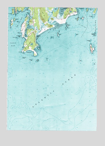
Small Point, ME USGS Topographic Map
Click on map above to begin viewing in our Map Viewer.

This topographic map contains these locations and features:
Feature Name Type Latitude Longitude GNIS ID View Map
Bald HeadCapeN43.7043°W69.8548°561494View Map
Bald Head CoveBayN43.7048°W69.8445°561501View Map
Bald Head LedgeBarN43.6987°W69.8537°561502View Map
Big PondLakeN43.7125°W69.8415°580230View Map
Bigelow BightBayN43.7043°W69.8537°578937View Map
Bill Wallace GroundBarN43.6943°W69.8437°581685View Map
Bold Dick RockCapeN43.7195°W69.8142°562709View Map
Buttonmold LedgesBarN43.6968°W69.8398°563319View Map
Camel GroundBarN43.6956°W69.7753°563377View Map
Campbell IslandIslandN43.7384°W69.8131°563437View Map
Cape SmallCapeN43.7120°W69.8448°563489View Map
Cape Small HarborBayN43.7354°W69.8464°563490View Map
Cape Small PondLakeN43.7123°W69.8414°562223View Map
Carrying Place CoveBayN43.7431°W69.8650°563616View Map
Carrying Place HeadCapeN43.7429°W69.8695°563621View Map
Ellingwood RockIslandN43.7168°W69.7600°565847View Map
Fish House CoveBayN43.7462°W69.8614°566203View Map
Flat PointCapeN43.7476°W69.8470°566287View Map
Fort BaldwinPopulated PlaceN43.7490°W69.7881°566403View Map
Fox IslandsIslandN43.7306°W69.7920°566515View Map
Fuller RockIslandN43.6959°W69.8334°566649View Map
Fuller Rock LighthouseLocaleN43.7290°W69.8298°1907807View Map
Goose RockIslandN43.7437°W69.8459°566939View Map
Gooseberry IslandIslandN43.7201°W69.8575°566949View Map
Gooseberry Island LedgeBarN43.7184°W69.8606°566954View Map
Halibut RocksBarN43.6973°W69.8192°567492View Map
Haskell HillSummitN43.7304°W69.8525°580281View Map
Head BeachBeachN43.7187°W69.8512°567846View Map
Head CoveBayN43.7093°W69.8523°567848View Map
Hermit IslandIslandN43.7290°W69.8531°567952View Map
Hermit Island CampgroundLocaleN43.7223°W69.8553°1907813View Map
Heron IslandIslandN43.7223°W69.8045°567959View Map
Hunnewell BeachBeachN43.7423°W69.7856°581441View Map
Isiah HeadCapeN43.7106°W69.8314°568686View Map
Jackknife LedgeBarN43.7226°W69.7803°568721View Map
Kennebec RiverStreamN43.7351°W69.7739°569110View Map
Little Wood IslandIslandN43.7373°W69.8659°570110View Map
Middle LedgeBarN43.7354°W69.8600°571252View Map
Mile LedgeBarN43.6931°W69.7553°571283View Map
Mill PointCapeN43.7415°W69.8484°571332View Map
Morse HillSummitN43.7318°W69.8163°571703View Map
Morse MountainSummitN43.7432°W69.8265°571706View Map
Morse PointCapeN43.7340°W69.7945°571708View Map
Morse RiverStreamN43.7323°W69.8064°571710View Map
Morses Mountain SanctuaryParkN43.7431°W69.8253°1907835View Map
Newbury PointCapeN43.7454°W69.8553°572135View Map
Ocean View Park CampgroundLocaleN43.7415°W69.7912°1907838View Map
Pitchpine LedgesBarN43.7418°W69.8520°581863View Map
Pond IslandIslandN43.7390°W69.7709°573599View Map
Pond Island LightLocaleN43.7399°W69.7702°1907850View Map
Pond Island National Wildlife RefugeParkN43.7395°W69.7707°2765459View Map
Pond Island ShoalBarN43.7315°W69.7706°573605View Map
Popham BeachBeachN43.7468°W69.7792°573633View Map
Popham Beach State ParkParkN43.7381°W69.7996°1907852View Map
Sabino HillSummitN43.7443°W69.7920°574637View Map
Salter IslandIslandN43.7473°W69.7537°574794View Map
Seal CoveBayN43.7056°W69.8334°575086View Map
Seal IslandIslandN43.7081°W69.8320°575106View Map
Seguin IslandIslandN43.7081°W69.7587°575226View Map
Seguin Island Light StationLocaleN43.7079°W69.7578°1907871View Map
Seguin LedgesBarN43.7237°W69.7548°575229View Map
Sequin South Southwest LedgeBarN43.6643°W69.7759°581897View Map
Silver LakeLakeN43.7458°W69.7874°575460View Map
Sister PointCapeN43.7459°W69.8595°575500View Map
Small PointCapeN43.7004°W69.8373°575561View Map
Small PointPopulated PlaceN43.7381°W69.8403°579699View Map
Small Point BeachPopulated PlaceN43.7209°W69.8367°575562View Map
Small Point HarborBayN43.7362°W69.8573°575564View Map
Small Point HillSummitN43.7351°W69.8437°575565View Map
Small Point Yacht ClubLocaleN43.7334°W69.8439°1907877View Map
South Sugarloaf IslandIslandN43.7479°W69.7720°575909View Map
Spirit PondLakeN43.7484°W69.8081°576058View Map
Spoonbowl LedgeBarN43.7134°W69.8592°580282View Map
Sprague RiverStreamN43.7220°W69.8348°576080View Map
Stage IslandIslandN43.7481°W69.7648°576226View Map
Stage Island BayBayN43.7484°W69.7595°576227View Map
The BranchBayN43.7256°W69.8498°576768View Map
Town of PhippsburgCivilN43.7447°W69.8316°582675View Map
Wallace CemeteryCemeteryN43.7116°W69.8471°2737006View Map
Wallace HeadCapeN43.7237°W69.8581°577803View Map
West PointCapeN43.7437°W69.8625°578195View Map
West PointPopulated PlaceN43.7470°W69.8645°578200View Map
Whaleback RockIslandN43.7412°W69.7573°578297View Map
White LedgeBarN43.7287°W69.7512°581962View Map
Wood IslandIslandN43.7340°W69.8692°578646View Map
Wood IslandIslandN43.7384°W69.7775°578647View Map
Wood Island South LedgeBarN43.7265°W69.8709°581964View Map

Note: Coordinates in the location and feature list above are referenced to NAD83 datum.


Copyright (C) 2008-2025 Ryan Niemi / Sunset Dynamics ... All Rights Reserved