TopoQuest Logo
Do you find TopoQuest useful?
Help keep TopoQuest running and adding new maps/features by donating!
Bitcoin:  19c7KJd3qBynnjoSw5npx9KScwjBe4ifkT
Litecoin:  LXs6TkuXGGXo1vDsWCkWVdjQX94eUKd6ui
Home View Maps Find Maps Find Places Resources & Links


Lake Catherine, Arkansas Topographic Map

USGS Map Title: Lake Catherine, AR
USGS Map MRC: 34092D8
DRG (GeoTIFF) Download: o34092d8.tif


Neighboring USGS Topographic Map Quads:


  Hot Springs North, AR  
34093E1
 

  Fountain Lake, AR  
34092E8
 

  Lonsdale, AR  
34092E7
 

  Hot Springs South, AR  
34093D1
 

  Lake Catherine, AR  
34092D8
 

  Malvern North, AR  
34092D7
 

  De Roche, AR  
34093C1
 

  Social Hill, AR  
34092C8
 

  Malvern South, AR  
34092C7


Map MRC Location:

N35°
W93°
N35°
W92°
H8 H7 H6 H5 H4 H3 H2 H1
G8 G7 G6 G5 G4 G3 G2 G1
F8 F7 F6 F5 F4 F3 F2 F1
E8 E7 E6 E5 E4 E3 E2 E1
D8 D7 D6 D5 D4 D3 D2 D1
C8 C7 C6 C5 C4 C3 C2 C1
B8 B7 B6 B5 B4 B3 B2 B1
A8 A7 A6 A5 A4 A3 A2 A1
N34°
W93°
N34°
W92°

Lake Catherine, AR USGS 1:24K Topographic Map Preview:
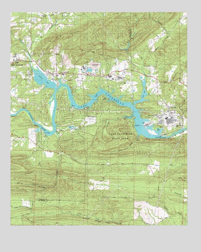
Lake Catherine, AR USGS Topographic Map
Click on map above to begin viewing in our Map Viewer.

This topographic map contains these locations and features:
Feature Name Type Latitude Longitude GNIS ID View Map
Arkansas Noname 110 DamDamN34.4668°W92.9402°81161View Map
Bald MountainRidgeN34.4868°W92.9613°46046View Map
Boss Island CreekStreamN34.4659°W92.9063°46846View Map
Camp CouchdaleLocaleN34.4306°W92.9666°47311View Map
Camp TanakoLocaleN34.4281°W92.9752°47339View Map
Cedar CreekStreamN34.4968°W92.9616°47589View Map
Cook MountainRidgeN34.4595°W92.8854°47979View Map
Cooper CreekStreamN34.4301°W92.9677°48011View Map
Cove CreekStreamN34.4326°W92.8771°48102View Map
Cove Creek (historical)Populated PlaceN34.4479°W92.8949°66082View Map
Cove Creek Station (historical)LocaleN34.4376°W92.8777°70024View Map
Crouchwood LakeReservoirN34.4668°W92.9152°81006View Map
Crouchwood Lake DamDamN34.4668°W92.9152°81005View Map
DiamondheadPopulated PlaceN34.4398°W92.9452°57654View Map
Diamondhead Police DepartmentBuildingN34.4325°W92.9518°2118811View Map
East Branch Gulpha CreekStreamN34.4745°W92.9857°48752View Map
Falls CreekStreamN34.4279°W92.9093°49001View Map
Gulpha CreekStreamN34.4662°W92.9843°77086View Map
Irwin CemeteryCemeteryN34.4829°W92.9849°50526View Map
Jones MillsPopulated PlaceN34.4376°W92.8877°57997View Map
Jones Mills Post OfficePost OfficeN34.4393°W92.8929°84357View Map
Justus Mill (historical)LocaleN34.4712°W92.8866°70026View Map
KBHS-AM (Hot Springs)TowerN34.4987°W92.9793°85311View Map
Lake CatherinePopulated PlaceN34.4643°W92.9724°64324View Map
Lake CatherineReservoirN34.4268°W92.8868°80152View Map
Lake CatherineReservoirN34.4543°W92.9593°74732View Map
Lake Catherine State ParkParkN34.4270°W92.9221°50940View Map
Lake Hamilton Fire Department Station 4BuildingN34.4227°W92.9824°2116683View Map
Lake Hamilton Fire Department Station 5BuildingN34.4307°W92.9490°2116684View Map
Lakeside Elementary SchoolSchoolN34.4723°W92.9949°64325View Map
Lakeside High SchoolSchoolN34.4741°W92.9968°83457View Map
Lakeside Intermediate SchoolSchoolN34.4722°W92.9977°64326View Map
Lakeside Junior High SchoolSchoolN34.4738°W92.9982°2039274View Map
Lakeside Middle SchoolSchoolN34.4752°W92.9925°2039275View Map
Lakeside Primary SchoolSchoolN34.4721°W92.9991°2039273View Map
Lecroy Post Office (historical)Post OfficeN34.4373°W92.8779°84518View Map
Morning Star Fire Department Station 2BuildingN34.4584°W92.9522°2116811View Map
Morning Star Fire Department Station 3BuildingN34.4598°W92.8959°2116812View Map
Morning Star Fire Department Station 4BuildingN34.4506°W92.9986°2116813View Map
Narrow MountainRidgeN34.4173°W92.9121°52573View Map
Potash Sulphur Springs (historical)Populated PlaceN34.4751°W92.9632°64346View Map
PricePopulated PlaceN34.4626°W92.9335°64347View Map
Price CemeteryCemeteryN34.4658°W92.9191°53789View Map
Remmel DamDamN34.4269°W92.8942°75101View Map
Ross Ferry (historical)CrossingN34.4343°W92.9696°64350View Map
Shinn MountainSummitN34.3768°W92.9843°58618View Map
Shorewood HillsPopulated PlaceN34.4376°W92.8960°58622View Map
Slunger BayBayN34.4381°W92.9155°54919View Map
Slunger CreekStreamN34.4390°W92.9205°54920View Map
Spencer BayBayN34.4601°W92.9763°55061View Map
Spring Lake (historical)Populated PlaceN34.4820°W92.9905°64355View Map
Spurlins Ferry (historical)CrossingN34.4451°W92.9685°64356View Map
Stony CreekStreamN34.4520°W92.9024°55247View Map
Sulphur Springs ChurchChurchN34.4634°W92.9430°55328View Map
Tailings PondReservoirN34.4668°W92.9402°81162View Map
Tigre BayBayN34.4523°W92.9057°55572View Map
Tigre CreekStreamN34.4593°W92.9052°78556View Map
Township of Sulphur (historical)CivilN34.4612°W92.9502°66599View Map
Wiggins CreekStreamN34.4873°W92.8868°56345View Map

Note: Coordinates in the location and feature list above are referenced to NAD83 datum.


Copyright (C) 2008-2024 Ryan Niemi / Sunset Dynamics ... All Rights Reserved