TopoQuest Logo
Do you find TopoQuest useful?
Help keep TopoQuest running and adding new maps/features by donating!
Bitcoin:  19c7KJd3qBynnjoSw5npx9KScwjBe4ifkT
Litecoin:  LXs6TkuXGGXo1vDsWCkWVdjQX94eUKd6ui
Home View Maps Find Maps Find Places Resources & Links


Society Hill, Alabama Topographic Map

USGS Map Title: Society Hill, AL
USGS Map MRC: 32085D4
DRG (GeoTIFF) Download: o32085d4.tif


Neighboring USGS Topographic Map Quads:


  Loachapoka, AL  
32085E5
 

  Auburn, AL  
32085E4
 

  Parkers Crossroads, AL  
32085E3
 

  Little Texas, AL  
32085D5
 

  Society Hill, AL  
32085D4
 

  Marvyn, AL  
32085D3
 

  Warriorstand, AL  
32085C5
 

  Creek Stand, AL  
32085C4
 

  Hatchechubbee, AL  
32085C3


Map MRC Location:

N33°
W86°
N33°
W85°
H8 H7 H6 H5 H4 H3 H2 H1
G8 G7 G6 G5 G4 G3 G2 G1
F8 F7 F6 F5 F4 F3 F2 F1
E8 E7 E6 E5 E4 E3 E2 E1
D8 D7 D6 D5 D4 D3 D2 D1
C8 C7 C6 C5 C4 C3 C2 C1
B8 B7 B6 B5 B4 B3 B2 B1
A8 A7 A6 A5 A4 A3 A2 A1
N32°
W86°
N32°
W85°

Society Hill, AL USGS 1:24K Topographic Map Preview:
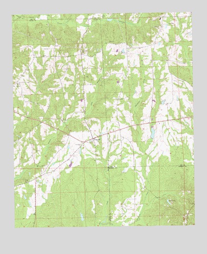
Society Hill, AL USGS Topographic Map
Click on map above to begin viewing in our Map Viewer.

This topographic map contains these locations and features:
Feature Name Type Latitude Longitude GNIS ID View Map
Ag Engineering Farm PondDamN32.4251°W85.4033°130558View Map
Agricultural Engineering Unit Auburn UniversityLocaleN32.4390°W85.4061°163463View Map
Ailey BranchStreamN32.4571°W85.4827°133988View Map
Beauregard Volunteer Fire Department Station 3BuildingN32.4985°W85.3933°2691525View Map
Bennett BranchStreamN32.4571°W85.4827°133995View Map
Bethel ChurchChurchN32.4793°W85.4205°164028View Map
Big CreekStreamN32.3765°W85.4402°114257View Map
Brownville Number One School (historical)SchoolN32.4746°W85.4705°133999View Map
Brownville Number Two School (historical)SchoolN32.4601°W85.4966°134000View Map
Brownville Volunteer Fire DepartmentBuildingN32.4554°W85.4945°2691215View Map
Cobbs CemeteryCemeteryN32.4799°W85.4752°116331View Map
Crump Chapel ChurchChurchN32.4618°W85.4222°163470View Map
Engineering Farm PondReservoirN32.4251°W85.4033°130559View Map
Groce LakeReservoirN32.3930°W85.4926°130516View Map
Holt CemeteryCemeteryN32.4637°W85.4494°120298View Map
Huskeys DamDamN32.3768°W85.4566°130501View Map
Huskeys PondReservoirN32.3768°W85.4566°130500View Map
J P Groce DamDamN32.3918°W85.4933°130517View Map
Jacobs DamDamN32.4935°W85.4349°130622View Map
Kelly Pond Number TwoReservoirN32.3894°W85.4893°130512View Map
Kellys Pond Number OneReservoirN32.4068°W85.4890°130535View Map
Lake JacobsReservoirN32.4935°W85.4349°130623View Map
Mullins School (historical)SchoolN32.4396°W85.4283°138241View Map
Odom CreekStreamN32.4962°W85.4377°124183View Map
Providence ChurchChurchN32.4093°W85.4430°163797View Map
Providence ChurchChurchN32.4257°W85.4449°134052View Map
Reese ChapelChurchN32.4388°W85.3791°153126View Map
Saint Paul CemeteryCemeteryN32.4024°W85.4908°154820View Map
Saint Pauls ChurchChurchN32.4021°W85.4908°153291View Map
Samford School (historical)SchoolN32.4943°W85.3958°138296View Map
Sand Creek ChurchChurchN32.4113°W85.4811°153315View Map
Sanford High SchoolSchoolN32.4965°W85.3969°163485View Map
Sanford Middle SchoolSchoolN32.4971°W85.3966°163486View Map
Shiloh ChurchChurchN32.4601°W85.4972°126739View Map
Society HillPopulated PlaceN32.4265°W85.4452°155245View Map
Society Hill CemeteryCemeteryN32.4254°W85.4447°137127View Map
Society Hill ChurchChurchN32.4235°W85.4541°127090View Map
Strawberry BranchStreamN32.3765°W85.4402°1805611View Map
T U Kelly Number 1 DamDamN32.4085°W85.4899°130536View Map
T U Kelly Number 2 DamDamN32.3885°W85.4899°130511View Map
Talbert DamDamN32.3901°W85.3949°130515View Map
Talbert LakeReservoirN32.3891°W85.3930°127638View Map
Tsinia Wildlife Viewing AreaParkN32.4401°W85.4055°164513View Map
Whatley CemeteryCemeteryN32.4787°W85.4524°128821View Map
Whatley School (historical)SchoolN32.4774°W85.4527°134070View Map
Wright CemeteryCemeteryN32.4483°W85.4436°2080468View Map
Zion ChurchChurchN32.4499°W85.4266°164154View Map

Note: Coordinates in the location and feature list above are referenced to NAD83 datum.


Copyright (C) 2008-2025 Ryan Niemi / Sunset Dynamics ... All Rights Reserved