TopoQuest Logo
Do you find TopoQuest useful?
Help keep TopoQuest running and adding new maps/features by donating!
Bitcoin:  19c7KJd3qBynnjoSw5npx9KScwjBe4ifkT
Litecoin:  LXs6TkuXGGXo1vDsWCkWVdjQX94eUKd6ui
Home View Maps Find Maps Find Places Resources & Links


Soldier Camp Mountain, Oregon Topographic Map

USGS Map Title: Soldier Camp Mountain, OR
USGS Map MRC: 42124E2
DRG (GeoTIFF) Download: o42124e2.tif


Neighboring USGS Topographic Map Quads:


  Father Mountain, OR  
42124F3
 

  Ophir Mountain, OR  
42124F2
 

  Illahe, OR  
42124F1
 

  Brushy Bald Mountain, OR  
42124E3
 

  Soldier Camp Mountain, OR  
42124E2
 

  Agness, OR  
42124E1
 

  Signal Buttes, OR  
42124D3
 

  Quosatana Butte, OR  
42124D2
 

  Horse Sign Butte, OR  
42124D1


Map MRC Location:

N43°
W125°
N43°
W124°
H8 H7 H6 H5 H4 H3 H2 H1
G8 G7 G6 G5 G4 G3 G2 G1
F8 F7 F6 F5 F4 F3 F2 F1
E8 E7 E6 E5 E4 E3 E2 E1
D8 D7 D6 D5 D4 D3 D2 D1
C8 C7 C6 C5 C4 C3 C2 C1
B8 B7 B6 B5 B4 B3 B2 B1
A8 A7 A6 A5 A4 A3 A2 A1
N42°
W125°
N42°
W124°

Soldier Camp Mountain, OR USGS 1:24K Topographic Map Preview:
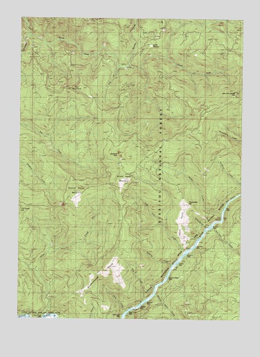
Soldier Camp Mountain, OR USGS Topographic Map
Click on map above to begin viewing in our Map Viewer.

This topographic map contains these locations and features:
Feature Name Type Latitude Longitude GNIS ID View Map
Adams PrairieRidgeN42.5476°W124.1595°1156670View Map
Auberry CreekStreamN42.5226°W124.1631°1158958View Map
Auberry RiffleRapidsN42.5268°W124.1579°1638049View Map
Bacon FlatBendN42.5007°W124.2318°1154402View Map
Bear CanyonValleyN42.5471°W124.1348°1159199View Map
Bear RiffleRapidsN42.5526°W124.1251°1159181View Map
Boulder CreekStreamN42.6051°W124.1901°1138471View Map
Bridge CreekStreamN42.5443°W124.1370°1138606View Map
Combs RiffleRapidsN42.5234°W124.1623°1159190View Map
Dog CreekStreamN42.5082°W124.1790°1159196View Map
Fall MountainSummitN42.5960°W124.2185°1141993View Map
Iron CreekStreamN42.6046°W124.1945°1144112View Map
JoAnn CreekStreamN42.5179°W124.1651°1154401View Map
Lake of the Woods MountainSummitN42.5939°W124.1284°1144742View Map
Little CanyonValleyN42.5407°W124.1393°1159200View Map
Lower River TrailTrailN42.5229°W124.1651°1145636View Map
Nail Keg CreekStreamN42.5384°W124.1415°1146721View Map
Nail Keg RiffleRapidsN42.5379°W124.1440°1159188View Map
New RiffleRapidsN42.5462°W124.1356°1159187View Map
North Fork Lobster CreekStreamN42.6173°W124.2462°1146973View Map
Potato Illahe MountainSummitN42.5475°W124.1580°1147937View Map
Rachels Delight RiffleRapidsN42.5173°W124.1673°1159197View Map
Sawtooth RockPillarN42.5689°W124.1955°1149105View Map
Schoolhouse CreekStreamN42.5387°W124.1434°1149135View Map
Second Prairie MountainSummitN42.5525°W124.2173°1149209View Map
Sherman RiffleRapidsN42.5076°W124.1804°1159191View Map
Shindler RiffleRapidsN42.5054°W124.1831°1159192View Map
Silver CreekStreamN42.5012°W124.2362°1149483View Map
Silver Creek RiffleRapidsN42.5007°W124.2373°1159195View Map
Skookumhouse PrairieFlatN42.5190°W124.2029°1149625View Map
Slide CreekStreamN42.5032°W124.1906°1159198View Map
Slide Creek RiffleRapidsN42.5034°W124.1901°1159193View Map
Soldier Camp MountainSummitN42.5584°W124.1925°1149863View Map
South Fork Lobster CreekStreamN42.6176°W124.2462°1149987View Map
Steffin MeadowFlatN42.6139°W124.1778°1150397View Map
Tom East CreekStreamN42.5279°W124.1565°1151315View Map
Tom East RiffleRapidsN42.5304°W124.1526°1159189View Map
Upper Coal RiffleRapidsN42.5012°W124.1929°1159194View Map
Wake Up Rilea CreekStreamN42.5101°W124.1737°1136988View Map

Note: Coordinates in the location and feature list above are referenced to NAD83 datum.


Copyright (C) 2008-2025 Ryan Niemi / Sunset Dynamics ... All Rights Reserved