TopoQuest Logo
Do you find TopoQuest useful?
Help keep TopoQuest running and adding new maps/features by donating!
Bitcoin:  19c7KJd3qBynnjoSw5npx9KScwjBe4ifkT
Litecoin:  LXs6TkuXGGXo1vDsWCkWVdjQX94eUKd6ui
Home View Maps Find Maps Find Places Resources & Links


Soldiers Pass, Utah Topographic Map

USGS Map Title: Soldiers Pass, UT
USGS Map MRC: 40111B8
DRG (GeoTIFF) Download: o40111b8.tif


Neighboring USGS Topographic Map Quads:


  Cedar Fort, UT  
40112C1
 

  Saratoga Springs, UT  
40111C8
 

  Pelican Point, UT  
40111C7
 

  Goshen Pass, UT  
40112B1
 

  Soldiers Pass, UT  
40111B8
 

  Lincoln Point, UT  
40111B7
 

  Allens Ranch, UT  
40112A1
 

  Goshen Valley North, UT  
40111A8
 

  West Mountain, UT  
40111A7


Map MRC Location:

N41°
W112°
N41°
W111°
H8 H7 H6 H5 H4 H3 H2 H1
G8 G7 G6 G5 G4 G3 G2 G1
F8 F7 F6 F5 F4 F3 F2 F1
E8 E7 E6 E5 E4 E3 E2 E1
D8 D7 D6 D5 D4 D3 D2 D1
C8 C7 C6 C5 C4 C3 C2 C1
B8 B7 B6 B5 B4 B3 B2 B1
A8 A7 A6 A5 A4 A3 A2 A1
N40°
W112°
N40°
W111°

Soldiers Pass, UT USGS 1:24K Topographic Map Preview:
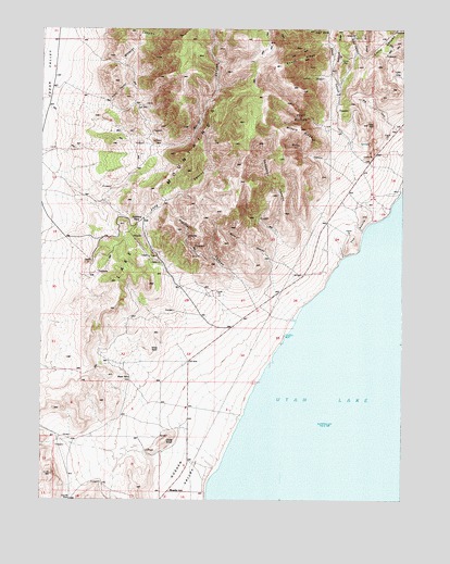
Soldiers Pass, UT USGS Topographic Map
Click on map above to begin viewing in our Map Viewer.

This topographic map contains these locations and features:
Feature Name Type Latitude Longitude GNIS ID View Map
Black PointCliffN40.1580°W111.9716°1425697View Map
Burnt CanyonValleyN40.1772°W111.9169°1426176View Map
Cat HillSummitN40.1316°W111.9969°1426402View Map
Chaparral CanyonValleyN40.1861°W111.9005°1426531View Map
Clyde KnollSummitN40.1408°W111.9574°1426734View Map
Dutchman RidgeRidgeN40.2458°W111.8974°1427638View Map
Enoch CanyonValleyN40.2302°W111.8985°1427826View Map
Enoch DivideRidgeN40.2491°W111.9044°1427828View Map
Enoch RidgeRidgeN40.2419°W111.9122°1427829View Map
GorderPopulated PlaceN40.1666°W111.9174°1448433View Map
Hells KitchenBasinN40.2269°W111.9110°1428652View Map
Iron HillSummitN40.2247°W111.8880°1429040View Map
Ivans CanyonValleyN40.2316°W111.9919°1429066View Map
Lake MountainsSummitN40.2050°W111.9605°1429434View Map
Left Fork Enoch CanyonValleyN40.2461°W111.9038°1429535View Map
Long CanyonValleyN40.1988°W111.9647°1429887View Map
Mercer CanyonValleyN40.2211°W111.9680°1430227View Map
Miners CanyonValleyN40.2011°W111.8833°1430371View Map
Miners RidgeRidgeN40.2236°W111.9113°1430375View Map
MosidaPopulated PlaceN40.1272°W111.9566°1437643View Map
Pfeiffer CanyonValleyN40.1619°W111.9238°1431205View Map
Potter CanyonValleyN40.2305°W111.8991°1431444View Map
Right Fork Enoch CanyonValleyN40.2461°W111.9038°1431798View Map
Seep CanyonValleyN40.2433°W111.8910°1432315View Map
Soldiers PassGapN40.1983°W111.9674°1432625View Map
The KnollsSummitN40.2002°W111.8899°1433356View Map
White KnollSummitN40.1650°W111.9624°1434166View Map
Wildcat CanyonValleyN40.2408°W111.9738°1434268View Map

Note: Coordinates in the location and feature list above are referenced to NAD83 datum.


Copyright (C) 2008-2025 Ryan Niemi / Sunset Dynamics ... All Rights Reserved