TopoQuest Logo
Do you find TopoQuest useful?
Help keep TopoQuest running and adding new maps/features by donating!
Bitcoin:  19c7KJd3qBynnjoSw5npx9KScwjBe4ifkT
Litecoin:  LXs6TkuXGGXo1vDsWCkWVdjQX94eUKd6ui
Home View Maps Find Maps Find Places Resources & Links


Saratoga Springs, Utah Topographic Map

USGS Map Title: Saratoga Springs, UT
USGS Map MRC: 40111C8
DRG (GeoTIFF) Download: o40111c8.tif


Neighboring USGS Topographic Map Quads:


  Tickville Spring, UT  
40112D1
 

  Jordan Narrows, UT  
40111D8
 

  Lehi, UT  
40111D7
 

  Cedar Fort, UT  
40112C1
 

  Saratoga Springs, UT  
40111C8
 

  Pelican Point, UT  
40111C7
 

  Goshen Pass, UT  
40112B1
 

  Soldiers Pass, UT  
40111B8
 

  Lincoln Point, UT  
40111B7


Map MRC Location:

N41°
W112°
N41°
W111°
H8 H7 H6 H5 H4 H3 H2 H1
G8 G7 G6 G5 G4 G3 G2 G1
F8 F7 F6 F5 F4 F3 F2 F1
E8 E7 E6 E5 E4 E3 E2 E1
D8 D7 D6 D5 D4 D3 D2 D1
C8 C7 C6 C5 C4 C3 C2 C1
B8 B7 B6 B5 B4 B3 B2 B1
A8 A7 A6 A5 A4 A3 A2 A1
N40°
W112°
N40°
W111°

Saratoga Springs, UT USGS 1:24K Topographic Map Preview:
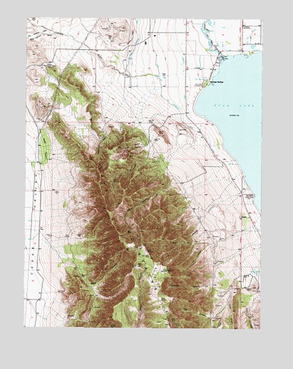
Saratoga Springs, UT USGS Topographic Map
Click on map above to begin viewing in our Map Viewer.

This topographic map contains these locations and features:
Feature Name Type Latitude Longitude GNIS ID View Map
Burnt CanyonValleyN40.3247°W111.9363°1426178View Map
City of Saratoga SpringsCivilN40.3448°W111.9154°2411833View Map
Clark CanyonValleyN40.3011°W111.8983°1426657View Map
Dry CreekStreamN40.3608°W111.8824°1440603View Map
Gardner CanalCanalN40.3633°W111.9213°1428140View Map
Glenmar Ranch AirportAirportN40.3391°W111.9994°2443195View Map
Israel CanyonValleyN40.3113°W111.9235°1429064View Map
KABE-FM (Orem)TowerN40.2827°W111.9372°1455788View Map
KFMY-FM (Provo)TowerN40.2800°W111.9355°1455787View Map
KLRZ-FM (Provo)TowerN40.2827°W111.9377°1455789View Map
LandrockSummitN40.3302°W111.9185°1429468View Map
Limekiln CanyonValleyN40.2683°W111.9002°1429623View Map
Little CanyonValleyN40.2625°W111.8783°1429689View Map
Long RidgeRidgeN40.2513°W111.8899°1429920View Map
Losee CanyonValleyN40.2844°W111.8994°1429937View Map
Lott CanyonValleyN40.3208°W111.9352°1429960View Map
Murdock Pumping StationLocaleN40.3352°W111.9066°1454483View Map
Olaf CanyonValleyN40.2716°W111.8852°1430963View Map
Reformation CanyonValleyN40.3341°W111.9552°1431740View Map
SaratogaParkN40.3491°W111.9055°1436319View Map
Saratoga ResortPopulated PlaceN40.3488°W111.9058°1436320View Map
Saratoga Resort Airport (historical)AirportN40.3486°W111.9077°1434582View Map
Saratoga SpringsPopulated PlaceN40.3491°W111.9047°1437677View Map
Tickville GulchValleyN40.3519°W111.9310°1433511View Map
Unified Fire Authority Fire Station 252 - Eagle MountainBuildingN40.3629°W111.9715°2627360View Map
Webb CedarsWoodsN40.3241°W111.9908°1434023View Map
West Canyon WashValleyN40.3686°W111.9863°1434056View Map
Wiley CanyonValleyN40.2766°W111.9752°1434291View Map

Note: Coordinates in the location and feature list above are referenced to NAD83 datum.


Copyright (C) 2008-2024 Ryan Niemi / Sunset Dynamics ... All Rights Reserved