TopoQuest Logo
Do you find TopoQuest useful?
Help keep TopoQuest running and adding new maps/features by donating!
Bitcoin:  19c7KJd3qBynnjoSw5npx9KScwjBe4ifkT
Litecoin:  LXs6TkuXGGXo1vDsWCkWVdjQX94eUKd6ui
Home View Maps Find Maps Find Places Resources & Links


Solgohachia, Arkansas Topographic Map

USGS Map Title: Solgohachia, AR
USGS Map MRC: 35092C6
DRG (GeoTIFF) Download: o35092c6.tif


Neighboring USGS Topographic Map Quads:


  Jerusalem, AR  
35092D7
 

  Cleveland, AR  
35092D6
 

  Formosa, AR  
35092D5
 

  Hattieville, AR  
35092C7
 

  Solgohachia, AR  
35092C6
 

  Springfield, AR  
35092C5
 

  Morrilton West, AR  
35092B7
 

  Morrilton East, AR  
35092B6
 

  Menifee, AR  
35092B5


Map MRC Location:

N36°
W93°
N36°
W92°
H8 H7 H6 H5 H4 H3 H2 H1
G8 G7 G6 G5 G4 G3 G2 G1
F8 F7 F6 F5 F4 F3 F2 F1
E8 E7 E6 E5 E4 E3 E2 E1
D8 D7 D6 D5 D4 D3 D2 D1
C8 C7 C6 C5 C4 C3 C2 C1
B8 B7 B6 B5 B4 B3 B2 B1
A8 A7 A6 A5 A4 A3 A2 A1
N35°
W93°
N35°
W92°

Solgohachia, AR USGS 1:24K Topographic Map Preview:
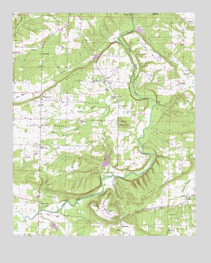
Solgohachia, AR USGS Topographic Map
Click on map above to begin viewing in our Map Viewer.

This topographic map contains these locations and features:
Feature Name Type Latitude Longitude GNIS ID View Map
Adams CemeteryCemeteryN35.3367°W92.6918°45782View Map
ArthurPopulated PlaceN35.3015°W92.6429°66177View Map
Bizzell CemeteryCemeteryN35.3281°W92.6796°46650View Map
Bull MountainSummitN35.3309°W92.7274°57466View Map
Camp PenielLocaleN35.2765°W92.7279°47332View Map
Conway CountyCivilN35.2622°W92.7013°66846View Map
Cypress ValleyPopulated PlaceN35.2709°W92.6302°56981View Map
Dutton MountainSummitN35.3442°W92.6407°57689View Map
East Fork Point Remove Site Eight DamDamN35.3517°W92.6918°79805View Map
East Fork Point Remove Site Eight ReservoirReservoirN35.3504°W92.6935°79806View Map
East Fork Point Remove Site Nine DamDamN35.2901°W92.6852°79807View Map
East Fork Point Remove Site Nine ReservoirReservoirN35.2920°W92.6863°79808View Map
East Fork Point Remove Site Seven DamDamN35.3651°W92.6652°79803View Map
East Fork Point Remove Site Seven ReservoirReservoirN35.3650°W92.6624°79804View Map
East Fork Point Remove Site Ten DamDamN35.2584°W92.7252°79809View Map
East Fork Point Remove Site Ten ReservoirReservoirN35.2586°W92.7253°79810View Map
Fonville CemeteryCemeteryN35.3320°W92.6846°49148View Map
Fowler LakeReservoirN35.3167°W92.6718°79634View Map
Fowler Lake DamDamN35.3167°W92.6718°79633View Map
Friendship CemeteryCemeteryN35.2512°W92.6757°49252View Map
Green CreekStreamN35.3667°W92.6671°49631View Map
Hall BranchStreamN35.3090°W92.6888°49781View Map
Jenkins MountainSummitN35.2604°W92.6857°50620View Map
LantyPopulated PlaceN35.3365°W92.6857°57086View Map
Lanty CemeteryCemeteryN35.3370°W92.6902°50990View Map
Lanty United Methodist ChurchChurchN35.3362°W92.6846°66198View Map
Lick MountainPopulated PlaceN35.3598°W92.6327°66200View Map
Lone GrovePopulated PlaceN35.3151°W92.7018°57094View Map
McClarenPopulated PlaceN35.3254°W92.6782°66201View Map
McClaren CemeteryCemeteryN35.3279°W92.6799°51790View Map
MiddletonPopulated PlaceN35.3362°W92.6363°58169View Map
Middleton CemeteryCemeteryN35.3404°W92.6293°51941View Map
Miller BranchStreamN35.3240°W92.6868°52054View Map
Mount Abel CemeteryCemeteryN35.3579°W92.6349°52257View Map
Mount Pisgah CemeteryCemeteryN35.2617°W92.6385°52376View Map
Mount Pisgah ChurchChurchN35.2526°W92.6404°52380View Map
Pilgrim ChurchChurchN35.3023°W92.6427°53373View Map
Prairie CreekStreamN35.2826°W92.6879°53761View Map
Ragsdale MountainSummitN35.2501°W92.6332°58454View Map
Round MountainSummitN35.3129°W92.6743°58532View Map
Round Mountain ChurchChurchN35.3231°W92.6782°54246View Map
Saint Marys CemeteryCemeteryN35.2973°W92.7346°54410View Map
Saint VincentPopulated PlaceN35.3012°W92.7316°57177View Map
Saint Vincent Fire StationBuildingN35.2964°W92.7320°2117084View Map
SolgohachiaPopulated PlaceN35.2562°W92.6763°54998View Map
Solgohachia Post OfficePost OfficeN35.2598°W92.6752°84367View Map
SunnysidePopulated PlaceN35.3687°W92.6277°58714View Map
Tenny CreekStreamN35.3587°W92.6771°55493View Map
Township of McLarenCivilN35.3221°W92.6749°66443View Map
Township of Saint VincentCivilN35.3082°W92.7272°66448View Map
Vinson ChapelChurchN35.3526°W92.7296°55924View Map
Wesley ChapelPopulated PlaceN35.2690°W92.7327°56157View Map
WonderviewPopulated PlaceN35.3279°W92.7299°58907View Map
Wonderview Elementary SchoolSchoolN35.3272°W92.7301°2039134View Map
Wonderview High SchoolSchoolN35.3283°W92.7294°66225View Map

Note: Coordinates in the location and feature list above are referenced to NAD83 datum.


Copyright (C) 2008-2024 Ryan Niemi / Sunset Dynamics ... All Rights Reserved