TopoQuest Logo
Do you find TopoQuest useful?
Help keep TopoQuest running and adding new maps/features by donating!
Bitcoin:  19c7KJd3qBynnjoSw5npx9KScwjBe4ifkT
Litecoin:  LXs6TkuXGGXo1vDsWCkWVdjQX94eUKd6ui
Home View Maps Find Maps Find Places Resources & Links


Sondheimer, Louisiana Topographic Map

USGS Map Title: Sondheimer, LA
USGS Map MRC: 32091E2
DRG (GeoTIFF) Download: o32091e2.tif


Neighboring USGS Topographic Map Quads:


  Caraway Lake, LA  
32091F3
 

  Transylvania, LA  
32091F2
 

  Fitler, MS  
32091F1
 

  Panther Lake, LA  
32091E3
 

  Sondheimer, LA  
32091E2
 

  Eagle Bend, MS  
32091E1
 

  Tendal, LA  
32091D3
 

  Tallulah, LA  
32091D2
 

  Ashly, LA  
32091D1


Map MRC Location:

N33°
W92°
N33°
W91°
H8 H7 H6 H5 H4 H3 H2 H1
G8 G7 G6 G5 G4 G3 G2 G1
F8 F7 F6 F5 F4 F3 F2 F1
E8 E7 E6 E5 E4 E3 E2 E1
D8 D7 D6 D5 D4 D3 D2 D1
C8 C7 C6 C5 C4 C3 C2 C1
B8 B7 B6 B5 B4 B3 B2 B1
A8 A7 A6 A5 A4 A3 A2 A1
N32°
W92°
N32°
W91°

Sondheimer, LA USGS 1:24K Topographic Map Preview:
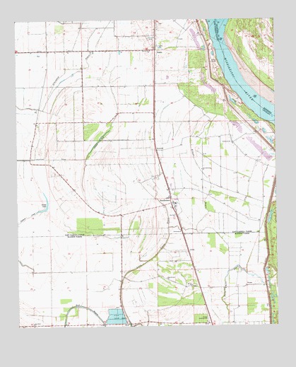
Sondheimer, LA USGS Topographic Map
Click on map above to begin viewing in our Map Viewer.

This topographic map contains these locations and features:
Feature Name Type Latitude Longitude GNIS ID View Map
AlsatiaPopulated PlaceN32.6129°W91.1823°541045View Map
BomerPopulated PlaceN32.5990°W91.1832°548844View Map
Broad LakeLakeN32.5485°W91.2364°553776View Map
Bull BayouStreamN32.5004°W91.1957°533526View Map
Ditch Number TwoCanalN32.6129°W91.2301°534533View Map
Dogtail LandingLocaleN32.5968°W91.1357°711149View Map
Dogtail LandingLocaleN32.6035°W91.1501°548852View Map
EnokaPopulated PlaceN32.5304°W91.1673°543185View Map
Fishers CreekGutN32.5451°W91.2448°534968View Map
Goodrich LandingLocaleN32.6229°W91.1568°548854View Map
Goodrich Plantation (historical)LocaleN32.6246°W91.1537°1631271View Map
Goodrich RevetmentLeveeN32.6121°W91.1534°548855View Map
Grassy LakeLakeN32.5769°W91.2092°554597View Map
Henderson SchoolSchoolN32.5749°W91.1465°535626View Map
King Solomon ChurchChurchN32.5199°W91.1784°536207View Map
Little Tensas BayouStreamN32.5946°W91.1679°536618View Map
Mount Zion ChurchChurchN32.5168°W91.1662°537450View Map
New Bethlehem ChurchChurchN32.5643°W91.1607°537554View Map
New Home ChurchChurchN32.5015°W91.2426°537572View Map
New Zion ChurchChurchN32.5457°W91.1737°537652View Map
OmegaPopulated PlaceN32.5165°W91.1396°541161View Map
Omega Landing StripAirportN32.5049°W91.1590°549505View Map
Parish Governing Authority District 1CivilN32.5858°W91.2495°1929734View Map
RooseveltPopulated PlaceN32.5721°W91.1823°543627View Map
Saint James ChurchChurchN32.5185°W91.1951°538860View Map
Salem CrevasseBasinN32.6093°W91.1543°539099View Map
Seventh Star ChurchChurchN32.6126°W91.1848°539261View Map
SondheimerPopulated PlaceN32.5501°W91.1759°539474View Map
Sondheimer Post Office (historical)Post OfficeN32.5487°W91.1757°1630871View Map
Stamboul (historical)Populated PlaceN32.6126°W91.1701°548876View Map
Ward OneCivilN32.5707°W91.1837°545006View Map
Wildcat BayouGutN32.5612°W91.1587°540401View Map

Note: Coordinates in the location and feature list above are referenced to NAD83 datum.


Copyright (C) 2008-2025 Ryan Niemi / Sunset Dynamics ... All Rights Reserved