TopoQuest Logo
Do you find TopoQuest useful?
Help keep TopoQuest running and adding new maps/features by donating!
Bitcoin:  19c7KJd3qBynnjoSw5npx9KScwjBe4ifkT
Litecoin:  LXs6TkuXGGXo1vDsWCkWVdjQX94eUKd6ui
Home View Maps Find Maps Find Places Resources & Links


Tallulah, Louisiana Topographic Map

USGS Map Title: Tallulah, LA
USGS Map MRC: 32091D2
DRG (GeoTIFF) Download: o32091d2.tif


Neighboring USGS Topographic Map Quads:


  Panther Lake, LA  
32091E3
 

  Sondheimer, LA  
32091E2
 

  Eagle Bend, MS  
32091E1
 

  Tendal, LA  
32091D3
 

  Tallulah, LA  
32091D2
 

  Ashly, LA  
32091D1
 

  Waverly SE, LA  
32091C3
 

  Fortune Fork, LA  
32091C2
 

  Mound, LA  
32091C1


Map MRC Location:

N33°
W92°
N33°
W91°
H8 H7 H6 H5 H4 H3 H2 H1
G8 G7 G6 G5 G4 G3 G2 G1
F8 F7 F6 F5 F4 F3 F2 F1
E8 E7 E6 E5 E4 E3 E2 E1
D8 D7 D6 D5 D4 D3 D2 D1
C8 C7 C6 C5 C4 C3 C2 C1
B8 B7 B6 B5 B4 B3 B2 B1
A8 A7 A6 A5 A4 A3 A2 A1
N32°
W92°
N32°
W91°

Tallulah, LA USGS 1:24K Topographic Map Preview:
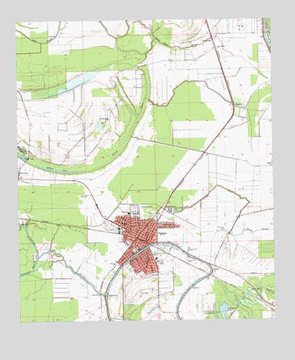
Tallulah, LA USGS Topographic Map
Click on map above to begin viewing in our Map Viewer.

This topographic map contains these locations and features:
Feature Name Type Latitude Longitude GNIS ID View Map
Brushy BayouStreamN32.3871°W91.2073°533462View Map
Christian Acres Alternative SchoolSchoolN32.4097°W91.1730°2462929View Map
City of TallulahCivilN32.4067°W91.1917°2405566View Map
Eagle LakeLakeN32.4443°W91.2493°554310View Map
East Star ChurchChurchN32.3860°W91.2109°534745View Map
EnglewoodPopulated PlaceN32.3851°W91.2071°543183View Map
Galilee ChurchChurchN32.3885°W91.1657°535155View Map
Grassy Lake CanalCanalN32.3813°W91.1423°535360View Map
Interchange 171CrossingN32.3926°W91.1996°541535View Map
KBYO-AM (Tallulah)TowerN32.4271°W91.2209°1632568View Map
KBYO-FM (Tallulah)TowerN32.4274°W91.2209°1632487View Map
Lake OneLakeN32.4149°W91.2473°555563View Map
Louisiana Delta Community College Tallulah CampusSchoolN32.3970°W91.2023°2462946View Map
LumsPopulated PlaceN32.3957°W91.1548°543425View Map
Macon SloughStreamN32.4107°W91.1473°536811View Map
Madison High SchoolSchoolN32.3983°W91.2064°549260View Map
Madison Middle SchoolSchoolN32.4155°W91.1992°1629709View Map
Madison Parish CourthouseBuildingN32.4082°W91.1873°549242View Map
Madison Parish HospitalHospitalN32.4036°W91.1848°2674117View Map
Madison Parish Office of Family SupportBuildingN32.4091°W91.1863°2391769View Map
Madison Parish Sheriff's OfficeBuildingN32.4083°W91.1874°2755341View Map
MansfordPopulated PlaceN32.4654°W91.1443°543441View Map
Marlin Airport (historical)AirportN32.3863°W91.1848°1632961View Map
Memorial Park CemeteryCemeteryN32.3999°W91.1682°539374View Map
Morning Crest CemeteryCemeteryN32.4212°W91.1743°537216View Map
Morning Star ChurchChurchN32.4885°W91.1518°537228View Map
Northeast Louisiana Marine Institute SchoolSchoolN32.4044°W91.1909°2462947View Map
Oakwood CemeteryCemeteryN32.3975°W91.2009°537809View Map
Panola BayouStreamN32.4046°W91.2351°537960View Map
Parish Governing Authority District 4CivilN32.4183°W91.1961°1930022View Map
Parish Governing Authority District 5CivilN32.4156°W91.1801°1930087View Map
Parish Governing Authority District 6CivilN32.4119°W91.1880°1930143View Map
Parish Governing Authority District 7CivilN32.4032°W91.1918°1930196View Map
Parish Governing Authority District 8CivilN32.3955°W91.1801°1930241View Map
Pleasant Hill ChurchChurchN32.4218°W91.1779°538257View Map
RichmondPopulated PlaceN32.3879°W91.1821°549262View Map
Scott AirportAirportN32.4129°W91.1497°1632960View Map
Silver Cross CemeteryCemeteryN32.4040°W91.1668°539375View Map
Stephen Hoyle Rehabilitation CenterSchoolN32.4147°W91.2022°2462948View Map
Talla BenaPopulated PlaceN32.4918°W91.1534°543713View Map
Talla Bena BayouGutN32.4890°W91.1721°539781View Map
TallulahPopulated PlaceN32.4085°W91.1868°1630017View Map
Tallulah Academy Delta Christian SchoolSchoolN32.3982°W91.1795°2462919View Map
Tallulah City Fire DepartmentBuildingN32.4104°W91.1947°2672914View Map
Tallulah Elementary SchoolSchoolN32.4007°W91.1831°549269View Map
Tallulah High School (historical)SchoolN32.4047°W91.1931°549270View Map
Tallulah Police DepartmentBuildingN32.4086°W91.1863°2755284View Map
Village of RichmondCivilN32.3884°W91.1804°2407536View Map
Ward EightCivilN32.3971°W91.1751°545128View Map
Ward FiveCivilN32.4157°W91.1784°545125View Map
Ward FourCivilN32.4182°W91.1987°545124View Map
Ward SevenCivilN32.4051°W91.1915°545127View Map
Ward SixCivilN32.4129°W91.1901°545126View Map
Willow BayouStreamN32.4376°W91.2204°540450View Map
Willow Bayou ChurchChurchN32.4590°W91.2051°540454View Map
Willow LakeLakeN32.4374°W91.2239°556437View Map
Wright Elementary SchoolSchoolN32.4199°W91.1957°1629816View Map

Note: Coordinates in the location and feature list above are referenced to NAD83 datum.


Copyright (C) 2008-2024 Ryan Niemi / Sunset Dynamics ... All Rights Reserved