TopoQuest Logo
Do you find TopoQuest useful?
Help keep TopoQuest running and adding new maps/features by donating!
Bitcoin:  19c7KJd3qBynnjoSw5npx9KScwjBe4ifkT
Litecoin:  LXs6TkuXGGXo1vDsWCkWVdjQX94eUKd6ui
Home View Maps Find Maps Find Places Resources & Links


Sonora, Kentucky Topographic Map

USGS Map Title: Sonora, KY
USGS Map MRC: 37085E8
DRG (GeoTIFF) Download: o37085e8.tif


Neighboring USGS Topographic Map Quads:


  Howe Valley, KY  
37086F1
 

  Cecilia, KY  
37085F8
 

  Elizabethtown, KY  
37085F7
 

  Summit, KY  
37086E1
 

  Sonora, KY  
37085E8
 

  Tonieville, KY  
37085E7
 

  Millerstown, KY  
37086D1
 

  Upton, KY  
37085D8
 

  Hammonville, KY  
37085D7


Map MRC Location:

N38°
W86°
N38°
W85°
H8 H7 H6 H5 H4 H3 H2 H1
G8 G7 G6 G5 G4 G3 G2 G1
F8 F7 F6 F5 F4 F3 F2 F1
E8 E7 E6 E5 E4 E3 E2 E1
D8 D7 D6 D5 D4 D3 D2 D1
C8 C7 C6 C5 C4 C3 C2 C1
B8 B7 B6 B5 B4 B3 B2 B1
A8 A7 A6 A5 A4 A3 A2 A1
N37°
W86°
N37°
W85°

Sonora, KY USGS 1:24K Topographic Map Preview:
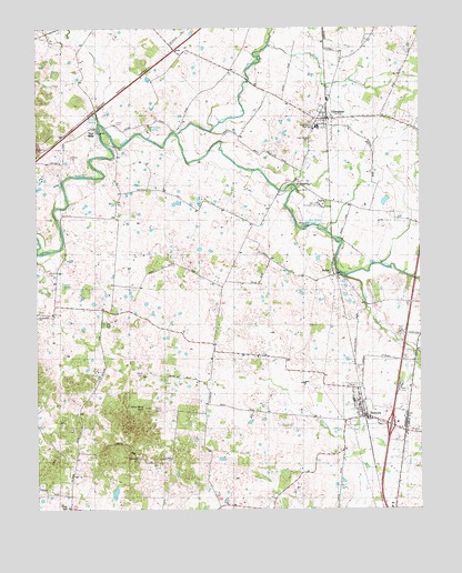
Sonora, KY USGS Topographic Map
Click on map above to begin viewing in our Map Viewer.

This topographic map contains these locations and features:
Feature Name Type Latitude Longitude GNIS ID View Map
Arrow SpringBasinN37.5561°W85.9959°507335View Map
Blacks BranchStreamN37.6245°W85.9940°2742504View Map
Bland CemeteryCemeteryN37.5353°W85.9669°487451View Map
Boiling SpringSpringN37.6025°W85.9812°487630View Map
Cherokee SpringBasinN37.5567°W85.9983°507336View Map
City of SonoraCivilN37.5319°W85.8948°2405484View Map
Cox RunStreamN37.5606°W85.8997°490231View Map
Dorsey RunStreamN37.5340°W85.9279°491020View Map
East Hardin High SchoolSchoolN37.5992°W85.9077°509471View Map
Gilead Baptist ChurchChurchN37.5843°W85.9146°492829View Map
Gilead SpringSpringN37.5826°W85.9152°507337View Map
Glen Dale Childrens HomeBuildingN37.5792°W85.9061°492885View Map
GlendalePopulated PlaceN37.6017°W85.9055°492892View Map
Glendale Fire DepartmentBuildingN37.6012°W85.9043°2636875View Map
Jeffries CemeteryCemeteryN37.5914°W85.9883°509474View Map
Little Zion ChurchChurchN37.5962°W85.9108°496903View Map
Morrison SpringSpringN37.5993°W85.9626°507338View Map
NolinPopulated PlaceN37.5612°W85.9027°499509View Map
Old Saint Ignatius CemeteryCemeteryN37.5514°W85.9983°509476View Map
Olive Hill ChurchChurchN37.5131°W85.9675°509472View Map
Rose RunStreamN37.6206°W85.9233°502343View Map
Saint Ignatius ChurchChurchN37.5512°W85.9994°502629View Map
Silver Mine KnobSummitN37.5262°W85.9644°503514View Map
Skees Spring (historical)SpringN37.5585°W85.9915°503597View Map
SonoraPopulated PlaceN37.5242°W85.8930°503878View Map
Sonora DivisionCivilN37.5172°W85.9741°1937264View Map
Sonora Fire DepartmentBuildingN37.5252°W85.8939°2636877View Map
Star MillsPopulated PlaceN37.5992°W85.9802°504267View Map
Star Mills SpringSpringN37.6012°W85.9791°507339View Map
Stone CemeteryCemeteryN37.6003°W85.9738°504448View Map
Taylors Bend ParkParkN37.5834°W85.9166°509473View Map
Utopia IslandIslandN37.5698°W85.9016°2742477View Map
Valley CreekStreamN37.5978°W85.9530°505940View Map

Note: Coordinates in the location and feature list above are referenced to NAD83 datum.


Copyright (C) 2008-2025 Ryan Niemi / Sunset Dynamics ... All Rights Reserved