TopoQuest Logo
Do you find TopoQuest useful?
Help keep TopoQuest running and adding new maps/features by donating!
Bitcoin:  19c7KJd3qBynnjoSw5npx9KScwjBe4ifkT
Litecoin:  LXs6TkuXGGXo1vDsWCkWVdjQX94eUKd6ui
Home View Maps Find Maps Find Places Resources & Links


Elizabethtown, Kentucky Topographic Map

USGS Map Title: Elizabethtown, KY
USGS Map MRC: 37085F7
DRG (GeoTIFF) Download: o37085f7.tif


Neighboring USGS Topographic Map Quads:


  Vine Grove, KY  
37085G8
 

  Colesburg, KY  
37085G7
 

  Lebanon Junction, KY  
37085G6
 

  Cecilia, KY  
37085F8
 

  Elizabethtown, KY  
37085F7
 

  Nelsonville, KY  
37085F6
 

  Sonora, KY  
37085E8
 

  Tonieville, KY  
37085E7
 

  Hodgenville, KY  
37085E6


Map MRC Location:

N38°
W86°
N38°
W85°
H8 H7 H6 H5 H4 H3 H2 H1
G8 G7 G6 G5 G4 G3 G2 G1
F8 F7 F6 F5 F4 F3 F2 F1
E8 E7 E6 E5 E4 E3 E2 E1
D8 D7 D6 D5 D4 D3 D2 D1
C8 C7 C6 C5 C4 C3 C2 C1
B8 B7 B6 B5 B4 B3 B2 B1
A8 A7 A6 A5 A4 A3 A2 A1
N37°
W86°
N37°
W85°

Elizabethtown, KY USGS 1:24K Topographic Map Preview:
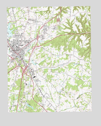
Elizabethtown, KY USGS Topographic Map
Click on map above to begin viewing in our Map Viewer.

This topographic map contains these locations and features:
Feature Name Type Latitude Longitude GNIS ID View Map
Bond-Washington School Historical MarkerParkN37.6889°W85.8543°2745078View Map
Brown-Pusey House Historical MarkerParkN37.6941°W85.8571°2744415View Map
Browns CemeteryCemeteryN37.7487°W85.8402°488031View Map
Buffalo CreekStreamN37.6915°W85.8500°509488View Map
Buffalo LakeReservoirN37.6987°W85.8430°509490View Map
Calvary Baptist ChurchChurchN37.7295°W85.8441°509487View Map
Carter (historical)Populated PlaceN37.6328°W85.7566°2569441View Map
Central Baptist ChurchChurchN37.6956°W85.8514°509486View Map
Central Hardin County Fire DepartmentBuildingN37.7313°W85.8409°2636874View Map
Central Hardin County Fire Department Station 2BuildingN37.6900°W85.8554°2637334View Map
Church of GodChurchN37.6540°W85.8289°509485View Map
Church of Jesus ChristChurchN37.7351°W85.8427°509484View Map
Coffmans LakeLakeN37.6814°W85.7751°489783View Map
Cole CreekStreamN37.6751°W85.8225°489810View Map
Commodore Joshua Barney Historical MarkerParkN37.6943°W85.8569°2744416View Map
East Rhudes Creek ChurchChurchN37.6323°W85.8669°491501View Map
ElizabethtownPopulated PlaceN37.6940°W85.8591°491640View Map
Elizabethtown Battle Historical MarkerParkN37.6889°W85.8542°2744414View Map
Elizabethtown City ParkParkN37.7076°W85.8516°509494View Map
Elizabethtown Country ClubLocaleN37.6431°W85.8189°517143View Map
Elizabethtown Country ClubLocaleN37.6417°W85.8164°509496View Map
Elizabethtown DivisionCivilN37.6971°W85.8316°1936986View Map
Elizabethtown Fire Department Station 2BuildingN37.6849°W85.8509°2636408View Map
Elizabethtown Fire Department Station 3BuildingN37.7320°W85.8739°2636560View Map
Elizabethtown Historical MarkerParkN37.6888°W85.8542°2745079View Map
Elizabethtown Police DepartmentBuildingN37.6911°W85.8634°2767455View Map
Freeman CreekStreamN37.6876°W85.8722°492512View Map
Freeman LakeReservoirN37.7217°W85.8708°509489View Map
Freeman Lake ParkParkN37.7203°W85.8736°509495View Map
General Custer Historical MarkerParkN37.6928°W85.8580°2744411View Map
Hardin County Historical MarkerParkN37.6932°W85.8581°2744413View Map
Hardin County Sheriff's OfficeBuildingN37.6931°W85.8580°2767688View Map
Holy CemeteryCemeteryN37.7084°W85.8727°494446View Map
Immanuel ChurchChurchN37.6828°W85.8469°494893View Map
Indian HillsPopulated PlaceN37.7090°W85.8461°494965View Map
Kentucky Division of Forestry Central DistrictBuildingN37.7140°W85.8236°2637371View Map
Kentucky State Police Post 4BuildingN37.7114°W85.8303°2767757View Map
Lincoln Trail SchoolSchoolN37.7226°W85.8152°496563View Map
Lincoln-Haycraft Memorial Bridge Historical MarkerParkN37.6919°W85.8561°2744412View Map
Locust Grove ChurchChurchN37.6509°W85.7927°496957View Map
McCullum CemeteryCemeteryN37.7095°W85.8547°497830View Map
Memorial United Methodist ChurchChurchN37.7023°W85.8555°509482View Map
Miller HillSummitN37.7165°W85.7527°498343View Map
Morgans Second Raid Historical MarkerParkN37.6888°W85.8542°2744410View Map
Morningside SchoolSchoolN37.7031°W85.8608°498606View Map
Neely BranchStreamN37.6445°W85.7683°499227View Map
New Hope Baptist ChurchChurchN37.6478°W85.8502°509483View Map
Oz AirportAirportN37.6536°W85.8110°2444062View Map
Poplar FlatsFlatN37.7453°W85.8052°501101View Map
Round Top ChurchChurchN37.6334°W85.8225°502415View Map
Saint James Catholic ChurchChurchN37.6962°W85.8619°509480View Map
Saint James CemeteryCemeteryN37.7065°W85.8558°502633View Map
Saint James High SchoolSchoolN37.6970°W85.8625°502636View Map
Saint James SchoolSchoolN37.6978°W85.8616°502637View Map
Sergeant George E Larkin Junior Historical MarkerParkN37.6932°W85.8580°2745077View Map
Severns Valley Baptist Church Historical MarkerParkN37.6947°W85.8579°2744417View Map
Severns Valley ChurchChurchN37.7006°W85.8644°503185View Map
Shaw CreekStreamN37.6923°W85.8730°503277View Map
Sportsman LakeReservoirN37.6321°W85.8423°504088View Map
Structure Number 3DamN37.7086°W85.8276°509491View Map
The Wesleyan ChurchChurchN37.7053°W85.8458°509481View Map
Tunnel HillSummitN37.7423°W85.8241°505572View Map
Tunnel Hill ChurchChurchN37.7431°W85.8330°505573View Map
Tunnel HillsPopulated PlaceN37.7328°W85.8314°509244View Map
Valley Creek ChurchChurchN37.6928°W85.7808°505941View Map
Valley Creek Fire DepartmentBuildingN37.6810°W85.7924°2636873View Map
Valley Creek ReservoirReservoirN37.6845°W85.8558°509497View Map
Valley Creek Structure Number 12DamN37.6989°W85.8448°509492View Map
Valley Creek Structure Number 4DamN37.7150°W85.8697°517306View Map
Valley Creek Structure Number 8DamN37.6845°W85.8558°509493View Map
Valley View SchoolSchoolN37.6853°W85.8491°505953View Map
Wheeler BranchStreamN37.6817°W85.8286°506525View Map
WIEL-AM (Elizabethtown)TowerN37.6865°W85.8719°517801View Map
WKZT-TV (Elizabethtown)TowerN37.6820°W85.8422°518044View Map

Note: Coordinates in the location and feature list above are referenced to NAD83 datum.


Copyright (C) 2008-2025 Ryan Niemi / Sunset Dynamics ... All Rights Reserved