TopoQuest Logo
Do you find TopoQuest useful?
Help keep TopoQuest running and adding new maps/features by donating!
Bitcoin:  19c7KJd3qBynnjoSw5npx9KScwjBe4ifkT
Litecoin:  LXs6TkuXGGXo1vDsWCkWVdjQX94eUKd6ui
Home View Maps Find Maps Find Places Resources & Links


Blackburn, Alabama Topographic Map

USGS Map Title: Blackburn, AL
USGS Map MRC: 34087H6
DRG (GeoTIFF) Download: o34087h6.tif


Neighboring USGS Topographic Map Quads:


  Cypress Inn, TN  
35087A7
 

  Whitten, TN  
35087A6
 

  Saint Joseph, TN  
35087A5
 

  Threet, AL  
34087H7
 

  Blackburn, AL  
34087H6
 

  Pruitton, AL  
34087H5
 

  Sinking Creek, AL  
34087G7
 

  Florence, AL  
34087G6
 

  Killen, AL  
34087G5


Map MRC Location:

N35°
W88°
N35°
W87°
H8 H7 H6 H5 H4 H3 H2 H1
G8 G7 G6 G5 G4 G3 G2 G1
F8 F7 F6 F5 F4 F3 F2 F1
E8 E7 E6 E5 E4 E3 E2 E1
D8 D7 D6 D5 D4 D3 D2 D1
C8 C7 C6 C5 C4 C3 C2 C1
B8 B7 B6 B5 B4 B3 B2 B1
A8 A7 A6 A5 A4 A3 A2 A1
N34°
W88°
N34°
W87°

Blackburn, AL USGS 1:24K Topographic Map Preview:
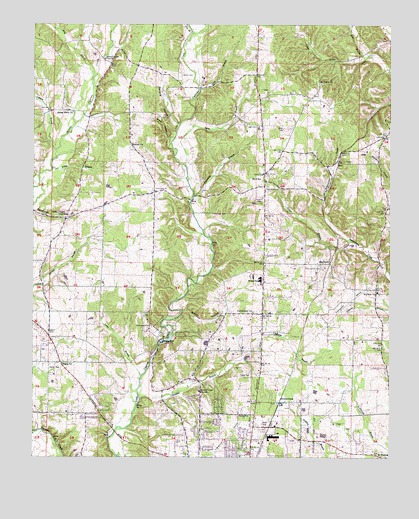
Blackburn, AL USGS Topographic Map
Click on map above to begin viewing in our Map Viewer.

This topographic map contains these locations and features:
Feature Name Type Latitude Longitude GNIS ID View Map
Bethel Berry Church of ChristChurchN34.9748°W87.7367°114009View Map
Bethel GrovePopulated PlaceN34.9904°W87.7256°166174View Map
Bethel Grove Community United Methodist ChurchChurchN34.9901°W87.7256°114088View Map
Bethel Grove School (historical)SchoolN34.9859°W87.7184°145068View Map
Big Cut StationLocaleN34.9609°W87.6436°114274View Map
BlackburnPopulated PlaceN34.9309°W87.6461°114438View Map
Bowie BranchStreamN34.9668°W87.7022°145077View Map
Bowie HollowValleyN34.9670°W87.7039°114772View Map
Bretherick Plantation (historical)LocaleN34.9654°W87.6986°145078View Map
Camp FlorenceLocaleN34.9173°W87.6689°145096View Map
Chisholm BranchStreamN34.8915°W87.7125°116067View Map
Chisholm CemeteryCemeteryN34.9026°W87.6706°116068View Map
Chisholm Heights ChurchChurchN34.9468°W87.6697°145110View Map
Chisholm School (historical)SchoolN34.9412°W87.6709°141146View Map
Community ChurchChurchN34.9168°W87.6736°116476View Map
Crossroads ChurchChurchN34.9520°W87.7064°163820View Map
Dry BranchStreamN34.9974°W87.6948°117521View Map
FairviewPopulated PlaceN34.9098°W87.7436°145164View Map
Fairview School (historical)SchoolN34.9101°W87.7445°155446View Map
Florence DivisionCivilN34.8900°W87.6444°165833View Map
Gambill HollowValleyN34.9712°W87.7006°118798View Map
Gooch HollowValleyN34.9170°W87.6978°119103View Map
Gray BranchStreamN34.9812°W87.6936°119290View Map
Hillsdale Methodist ChurchChurchN34.9656°W87.7164°120125View Map
HinesPopulated PlaceN34.9598°W87.6436°156479View Map
Hope Post OfficePost OfficeN34.9904°W87.7256°169237View Map
Ijams BranchStreamN34.8984°W87.7125°120618View Map
JacksonburgPopulated PlaceN34.8909°W87.6636°120787View Map
Jacksonburg Church of ChristChurchN34.8906°W87.6645°145235View Map
Keys Chapel (historical)Populated PlaceN34.9412°W87.6703°157331View Map
Latham BranchStreamN34.9637°W87.7425°151997View Map
Lauderdale CountyCivilN34.9014°W87.6540°161564View Map
Lyles BranchStreamN34.9590°W87.6978°122117View Map
May BranchStreamN34.9823°W87.7300°122413View Map
Mount Tabor School (historical)SchoolN34.9826°W87.6486°157362View Map
Mount Tabor United Methodist ChurchChurchN34.9831°W87.6500°152514View Map
Mount Zion Church of ChristChurchN34.9226°W87.6295°152545View Map
Mount Zion School (historical)SchoolN34.9284°W87.6297°142112View Map
Nolen CemeteryCemeteryN34.9854°W87.6995°123964View Map
Oak HillPopulated PlaceN34.8784°W87.6759°142136View Map
Parker Chapel Missionary Baptist ChurchChurchN34.9451°W87.7392°152843View Map
Parsonage BranchStreamN34.9504°W87.6950°124461View Map
Parsonage CemeteryCemeteryN34.9454°W87.6889°124462View Map
Parsonage Chapel United Methodist Church (historical)ChurchN34.9520°W87.6911°163977View Map
Piney Grove CemeteryCemeteryN34.9295°W87.6492°124869View Map
Piney Grove Church of Christ (historical)ChurchN34.9301°W87.6497°157368View Map
Piney Grove School (historical)SchoolN34.9290°W87.6497°142151View Map
Pisgah African Methodist Episcopal ChurchChurchN34.9020°W87.7398°152960View Map
Posey BranchStreamN34.9581°W87.7439°153050View Map
Richardson CemeteryCemeteryN34.9129°W87.7089°125610View Map
Rogers Chapel United Methodist ChurchChurchN34.9531°W87.6689°153114View Map
Salem Church of ChristChurchN34.9568°W87.6706°153300View Map
Savannah HollowValleyN34.9459°W87.7495°126437View Map
Sharps MillPopulated PlaceN34.9081°W87.7056°157044View Map
Sharps Mill DamDamN34.9084°W87.7050°132060View Map
Sharps Mill PondReservoirN34.9084°W87.7050°132061View Map
Sour BranchStreamN34.9901°W87.6342°127110View Map
Stoney Point (historical)Populated PlaceN34.8973°W87.6925°142210View Map
Stoney Point Church of ChristChurchN34.8940°W87.6920°153583View Map
Stoney Point School (historical)SchoolN34.8965°W87.6906°142211View Map
Striplin School (historical)SchoolN34.9315°W87.7078°155455View Map
SuncrestPopulated PlaceN34.8884°W87.6847°142215View Map
Terrace ViewPopulated PlaceN34.8918°W87.6850°142223View Map
Twin OaksPopulated PlaceN34.8848°W87.6750°142234View Map
Underwood-Petersville Census Designated PlaceCensusN34.8768°W87.6973°2402943View Map
Warren School (historical)SchoolN34.9754°W87.7372°155445View Map
Webster (historical)Populated PlaceN34.9495°W87.6486°142252View Map
Wilkes ParkPopulated PlaceN34.8776°W87.6886°142260View Map
WilsonPopulated PlaceN34.9270°W87.6695°142262View Map
Wilson BranchStreamN34.9376°W87.6392°129069View Map
Wilson Junior High SchoolSchoolN34.9259°W87.6706°165590View Map
Zip CityPopulated PlaceN34.9548°W87.6700°129364View Map
Zip City Volunteer Fire DepartmentBuildingN34.9505°W87.6698°2683025View Map

Note: Coordinates in the location and feature list above are referenced to NAD83 datum.


Copyright (C) 2008-2024 Ryan Niemi / Sunset Dynamics ... All Rights Reserved