TopoQuest Logo
Do you find TopoQuest useful?
Help keep TopoQuest running and adding new maps/features by donating!
Bitcoin:  19c7KJd3qBynnjoSw5npx9KScwjBe4ifkT
Litecoin:  LXs6TkuXGGXo1vDsWCkWVdjQX94eUKd6ui
Home View Maps Find Maps Find Places Resources & Links


Whitten, Tennessee Topographic Map

USGS Map Title: Whitten, TN
USGS Map MRC: 35087A6
DRG (GeoTIFF) Download: o35087a6.tif


Neighboring USGS Topographic Map Quads:


  Three Churches, TN  
35087B7
 

  Collinwood, TN  
35087B6
 

  Westpoint, TN  
35087B5
 

  Cypress Inn, TN  
35087A7
 

  Whitten, TN  
35087A6
 

  Saint Joseph, TN  
35087A5
 

  Threet, AL  
34087H7
 

  Blackburn, AL  
34087H6
 

  Pruitton, AL  
34087H5


Map MRC Location:

N36°
W88°
N36°
W87°
H8 H7 H6 H5 H4 H3 H2 H1
G8 G7 G6 G5 G4 G3 G2 G1
F8 F7 F6 F5 F4 F3 F2 F1
E8 E7 E6 E5 E4 E3 E2 E1
D8 D7 D6 D5 D4 D3 D2 D1
C8 C7 C6 C5 C4 C3 C2 C1
B8 B7 B6 B5 B4 B3 B2 B1
A8 A7 A6 A5 A4 A3 A2 A1
N35°
W88°
N35°
W87°

Whitten, TN USGS 1:24K Topographic Map Preview:
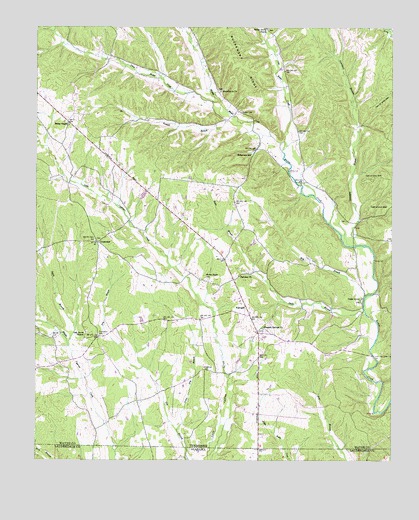
Whitten, TN USGS Topographic Map
Click on map above to begin viewing in our Map Viewer.

This topographic map contains these locations and features:
Feature Name Type Latitude Longitude GNIS ID View Map
Brewer CemeteryCemeteryN35.1006°W87.6781°1278291View Map
Brewer CemeteryCemeteryN35.0817°W87.6514°1641761View Map
Brewer CemeteryCemeteryN35.1206°W87.6967°1641762View Map
Burns ChapelChurchN35.0967°W87.7386°1305551View Map
Butler Grove CemeteryCemeteryN35.1245°W87.6689°1641768View Map
Butler School (historical)SchoolN35.1209°W87.6939°1302709View Map
Cedar Grove Baptist ChurchChurchN35.0465°W87.6361°1320126View Map
Cedar Grove CemeteryCemeteryN35.0465°W87.6353°1641772View Map
Cedar Grove School (historical)SchoolN35.0454°W87.6356°1302713View Map
Commissioner District 6CivilN35.0889°W87.6698°2464583View Map
CrossroadsPopulated PlaceN35.0629°W87.7278°1314912View Map
Crossroads ChurchChurchN35.0631°W87.7284°1302727View Map
Crossroads School (historical)SchoolN35.0659°W87.7225°1302728View Map
FairviewPopulated PlaceN35.0442°W87.6759°1315037View Map
Fairview ChurchChurchN35.0531°W87.6786°1284002View Map
Fairview Church of ChristChurchN35.0426°W87.6747°1308146View Map
Fairview School (historical)SchoolN35.0454°W87.6778°1302742View Map
Fantail BranchStreamN35.0992°W87.6809°1284126View Map
First Butler CreekStreamN35.1031°W87.6847°1269575View Map
Friendship CemeteryCemeteryN35.0365°W87.7278°1284922View Map
Friendship School (historical)SchoolN35.0979°W87.7403°1302746View Map
Hardwick CemeteryCemeteryN35.0340°W87.6797°1641810View Map
Hensley CemeteryCemeteryN35.0692°W87.6411°1641813View Map
Last Butler CreekStreamN35.0890°W87.6631°1269711View Map
Light (historical)Populated PlaceN35.0526°W87.6367°1302767View Map
Little Dry BranchStreamN35.0087°W87.7000°1291476View Map
Littrell-White ProspectMineN35.0729°W87.6406°1302768View Map
Lull MineMineN35.0154°W87.6300°1641871View Map
Macedonia CemeteryCemeteryN35.1067°W87.6859°1641845View Map
Macedonia ChurchChurchN35.1065°W87.6847°1292408View Map
Middle Butler CreekStreamN35.0892°W87.6634°1269798View Map
Mill BranchStreamN35.0476°W87.6339°1293789View Map
Oak Grove Baptist ChurchChurchN35.0370°W87.7317°1296079View Map
Oak Grove CemeteryCemeteryN35.0370°W87.7320°1641867View Map
Old Mount Bethel CemeteryCemeteryN35.0337°W87.6917°1641875View Map
Old Mount Bethel Methodist Church (historical)ChurchN35.0334°W87.6917°1641876View Map
Pleasant Springs ChurchChurchN35.0384°W87.6697°1297927View Map
Pleasant Valley (historical)Populated PlaceN35.0609°W87.7486°1302784View Map
Railroad CemeteryCemeteryN35.0376°W87.6695°1641889View Map
Roberson CemeteryCemeteryN35.0265°W87.6909°1299598View Map
Robertson SchoolSchoolN35.0884°W87.6739°1299675View Map
Robinson MineMineN35.0737°W87.6325°1641894View Map
Simmons CemeteryCemeteryN35.0406°W87.6836°1641905View Map
Southgate Volunteer Fire DepartmentBuildingN35.0452°W87.6788°2653669View Map
Spain BranchStreamN35.0331°W87.7381°1303745View Map
Star (historical)Populated PlaceN35.0956°W87.6581°1302799View Map
State Line Church (historical)ChurchN35.0073°W87.6711°1302801View Map
Stults BranchStreamN35.0426°W87.6339°1271620View Map
Stults ProspectMineN35.0265°W87.6453°1302805View Map
Swanegan BranchStreamN35.0623°W87.6375°1271946View Map
Sweaney School (historical)SchoolN35.0798°W87.6564°1302806View Map
Whitten Chapel CemeteryCemeteryN35.0529°W87.6903°1304571View Map
Whitten FarmsLocaleN35.0556°W87.6939°2706239View Map
Whitten School (historical)SchoolN35.0170°W87.7134°1302821View Map
Whittens Cross Roads CemeteryCemeteryN35.0631°W87.7292°1641929View Map

Note: Coordinates in the location and feature list above are referenced to NAD83 datum.


Copyright (C) 2008-2024 Ryan Niemi / Sunset Dynamics ... All Rights Reserved