TopoQuest Logo
Do you find TopoQuest useful?
Help keep TopoQuest running and adding new maps/features by donating!
Bitcoin:  19c7KJd3qBynnjoSw5npx9KScwjBe4ifkT
Litecoin:  LXs6TkuXGGXo1vDsWCkWVdjQX94eUKd6ui
Home View Maps Find Maps Find Places Resources & Links


Saint Joseph, Tennessee Topographic Map

USGS Map Title: Saint Joseph, TN
USGS Map MRC: 35087A5
DRG (GeoTIFF) Download: o35087a5.tif


Neighboring USGS Topographic Map Quads:


  Collinwood, TN  
35087B6
 

  Westpoint, TN  
35087B5
 

  Long Branch, TN  
35087B4
 

  Whitten, TN  
35087A6
 

  Saint Joseph, TN  
35087A5
 

  Loretto, TN  
35087A4
 

  Blackburn, AL  
34087H6
 

  Pruitton, AL  
34087H5
 

  Center Hill, AL  
34087H4


Map MRC Location:

N36°
W88°
N36°
W87°
H8 H7 H6 H5 H4 H3 H2 H1
G8 G7 G6 G5 G4 G3 G2 G1
F8 F7 F6 F5 F4 F3 F2 F1
E8 E7 E6 E5 E4 E3 E2 E1
D8 D7 D6 D5 D4 D3 D2 D1
C8 C7 C6 C5 C4 C3 C2 C1
B8 B7 B6 B5 B4 B3 B2 B1
A8 A7 A6 A5 A4 A3 A2 A1
N35°
W88°
N35°
W87°

Saint Joseph, TN USGS 1:24K Topographic Map Preview:
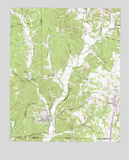
Saint Joseph, TN USGS Topographic Map
Click on map above to begin viewing in our Map Viewer.

This topographic map contains these locations and features:
Feature Name Type Latitude Longitude GNIS ID View Map
Allen ProspectMineN35.0348°W87.5597°1641936View Map
Belew CemeteryCemeteryN35.1034°W87.5131°1276894View Map
Berlin HollowValleyN35.0574°W87.6042°1277041View Map
Berlin ProspectMineN35.0623°W87.6186°1302704View Map
Big SpringSpringN35.0201°W87.5889°1302983View Map
Bird BranchStreamN35.1209°W87.5589°1277498View Map
Blackwell BranchStreamN35.0937°W87.6034°1277620View Map
Blair CemeteryCemeteryN35.1195°W87.5520°1277638View Map
Brewer BranchStreamN35.0587°W87.5686°1278289View Map
Bromley FordCrossingN35.1009°W87.5395°1314739View Map
Bromley MineMineN35.0354°W87.6078°1641764View Map
Caperton HollowValleyN35.1172°W87.6121°1279627View Map
Carter BranchStreamN35.0248°W87.5322°1279769View Map
Cedar Point MineMineN35.0292°W87.5797°1641941View Map
ChinubeePopulated PlaceN35.1231°W87.5186°1305904View Map
Chinubee CemeteryCemeteryN35.1148°W87.5203°1641975View Map
Chisholm CreekStreamN35.1198°W87.5389°1305906View Map
City of Iron City (historical)CivilN35.0254°W87.5841°2404764View Map
City of Saint JosephCivilN35.0323°W87.5018°2405395View Map
Clack BranchStreamN35.1067°W87.5067°1305934View Map
Commissioner District 6CivilN35.1234°W87.5133°2464551View Map
Corning (historical)Populated PlaceN35.0940°W87.6050°1302724View Map
Couch MineMineN35.0990°W87.5584°1641942View Map
Elting MineMineN35.1084°W87.6247°1641792View Map
Factory CreekStreamN35.0862°W87.5339°1303451View Map
GenevaPopulated PlaceN35.1215°W87.6222°1315106View Map
Hardin FordCrossingN35.0901°W87.5300°1315187View Map
Hardwick (historical)Populated PlaceN35.0709°W87.6034°1302752View Map
Hardwick MineMineN35.0731°W87.6139°1641811View Map
Hollis CemeteryCemeteryN35.0820°W87.6034°1288072View Map
Hollis ProspectMineN35.0434°W87.6220°1302756View Map
Holly CreekStreamN35.0254°W87.5786°1269649View Map
Holly CreekPopulated PlaceN35.0865°W87.6025°1315250View Map
Holly Creek ChurchChurchN35.0567°W87.6025°1302757View Map
Holly Creek School (historical)SchoolN35.1104°W87.6072°1302758View Map
Holly Creek Volunteer Fire DepartmentBuildingN35.0958°W87.6059°2653810View Map
Iron CityPopulated PlaceN35.0240°W87.5814°1289045View Map
Iron City Baptist ChurchChurchN35.0223°W87.5839°1308181View Map
Iron City Census Designated PlaceCensusN35.0226°W87.5855°2675244View Map
Iron City Freewill Baptist ChurchChurchN35.0240°W87.5817°1308182View Map
Iron City Methodist ChurchChurchN35.0220°W87.5850°1308183View Map
Iron City Post OfficePost OfficeN35.0213°W87.5818°1649112View Map
Iron City School (historical)SchoolN35.0187°W87.5842°1317736View Map
Iron City SpringSpringN35.0217°W87.5884°1641947View Map
Iron City Volunteer Fire DepartmentBuildingN35.0233°W87.5833°2653698View Map
Iron City-St. Joseph Division (historical)CensusN35.0720°W87.5345°1648821View Map
J B Powell MineMineN35.1056°W87.6247°1641831View Map
Keith HollowValleyN35.0986°W87.5197°1289977View Map
Little Wolf CreekStreamN35.0162°W87.5434°1291712View Map
Lower Holly CreekPopulated PlaceN35.0587°W87.6009°1292219View Map
Lull-White ProspectMineN35.0417°W87.6217°1302771View Map
Mackey BluffCliffN35.0412°W87.5606°1292449View Map
McKinney LakeReservoirN35.0222°W87.5403°1301477View Map
McKinney Lake DamDamN35.0217°W87.5400°1301476View Map
McKinney MineMineN35.0201°W87.5375°1303028View Map
Mount Lebo School (historical)SchoolN35.0579°W87.5375°1303033View Map
Mount NeboPopulated PlaceN35.0576°W87.5372°1315552View Map
Mount Nebo CemeteryCemeteryN35.0592°W87.5367°1642008View Map
Mount Nebo Cumberland Presbyterian ChurchChurchN35.0581°W87.5370°1642009View Map
Pinhook BranchStreamN35.0209°W87.5781°1297657View Map
Powell CemeteryCemeteryN35.0017°W87.6061°125225View Map
Powell MineMineN35.0473°W87.5547°1641954View Map
Powell Prospect Number OneMineN35.0756°W87.6172°1302787View Map
Powell Prospect Number TwoMineN35.0651°W87.6175°1302788View Map
Powell SpringSpringN35.0492°W87.5589°1298426View Map
Prince HollowValleyN35.0596°W87.6034°1298541View Map
Pruitt MineMineN35.0312°W87.6056°1641955View Map
Rhoades Hill (historical)Populated PlaceN35.0931°W87.5411°1641956View Map
Robertson SpringSpringN35.1093°W87.6114°1299676View Map
Rockford SchoolSchoolN35.0579°W87.6020°1299810View Map
Rocky HollowValleyN35.0756°W87.5550°1299899View Map
Saint JosephPopulated PlaceN35.0362°W87.5067°1300456View Map
Saint Joseph Catholic CemeteryCemeteryN35.0342°W87.5028°1642025View Map
Saint Joseph Catholic ChurchChurchN35.0331°W87.5031°1642026View Map
Saint Joseph CemeteryCemeteryN35.0387°W87.5050°1642027View Map
Saint Joseph City HallBuildingN35.0395°W87.5059°1308208View Map
Saint Joseph City ParkParkN35.0292°W87.5011°1308209View Map
Saint Joseph Elementary SchoolSchoolN35.0359°W87.5089°1308210View Map
Saint Joseph First Baptist ChurchChurchN35.0331°W87.5061°1317743View Map
Saint Joseph Post OfficePost OfficeN35.0351°W87.5060°1649125View Map
Saint Joseph United Methodist ChurchChurchN35.0381°W87.5059°1308213View Map
Saint Joseph Volunteer Fire DepartmentBuildingN35.0382°W87.5061°2653745View Map
Seavy-Lull MineMineN35.0309°W87.6034°1641957View Map
Shiloh CemeteryCemeteryN35.0420°W87.5347°1303576View Map
Tidwell BranchStreamN35.0851°W87.5356°1272617View Map
Tidwell HollowValleyN35.0846°W87.5327°1646872View Map
Tidwell SpringSpringN35.0773°W87.5217°1272628View Map
Upper Holly CreekPopulated PlaceN35.1101°W87.6075°1314442View Map
Upper Holly Creek ChurchChurchN35.0862°W87.6022°1302808View Map
Van Leer Furnace (historical)LocaleN35.0079°W87.6186°1641916View Map
Van Leer MineMineN35.0337°W87.6061°1641917View Map
Wade CemeteryCemeteryN35.0076°W87.5836°1273514View Map
Wade-Reynolds ProspectMineN35.0626°W87.6172°1641918View Map
Ward FordCrossingN35.0054°W87.5764°1303070View Map
Wayland SpringsPopulated PlaceN35.0617°W87.5747°1273955View Map
Wayland Springs CemeteryCemeteryN35.0590°W87.5750°1642036View Map
Wayland Springs Methodist ChurchChurchN35.0634°W87.5756°1308217View Map
Weaver BranchStreamN35.1017°W87.5356°1273984View Map
Williams BranchStreamN35.1129°W87.6092°1274633View Map
Wolf CreekPopulated PlaceN35.0156°W87.5428°1314528View Map
Wolf CreekStreamN35.0065°W87.5753°1274940View Map
Wolf Creek CemeteryCemeteryN35.0142°W87.5431°1642039View Map
Wolf Creek Church (historical)ChurchN35.0148°W87.5428°1303074View Map
Wolf Creek Mill (historical)LocaleN35.0104°W87.5539°1303075View Map

Note: Coordinates in the location and feature list above are referenced to NAD83 datum.


Copyright (C) 2008-2024 Ryan Niemi / Sunset Dynamics ... All Rights Reserved