TopoQuest Logo
Do you find TopoQuest useful?
Help keep TopoQuest running and adding new maps/features by donating!
Bitcoin:  19c7KJd3qBynnjoSw5npx9KScwjBe4ifkT
Litecoin:  LXs6TkuXGGXo1vDsWCkWVdjQX94eUKd6ui
Home View Maps Find Maps Find Places Resources & Links


South Branch, Michigan Topographic Map

USGS Map Title: South Branch, MI
USGS Map MRC: 44083D8
DRG (GeoTIFF) Download: o44083d8.tif


Neighboring USGS Topographic Map Quads:


  Mack Lake, MI  
44084E1
 

  Goodar, MI  
44083E8
 

  Alcona Dam Pond, MI  
44083E7
 

  Rose City, MI  
44084D1
 

  South Branch, MI  
44083D8
 

  Hale, MI  
44083D7
 

  Selkirk, MI  
44084C1
 

  Sage Lake, MI  
44083C8
 

  Hale SE, MI  
44083C7


Map MRC Location:

N45°
W84°
N45°
W83°
H8 H7 H6 H5 H4 H3 H2 H1
G8 G7 G6 G5 G4 G3 G2 G1
F8 F7 F6 F5 F4 F3 F2 F1
E8 E7 E6 E5 E4 E3 E2 E1
D8 D7 D6 D5 D4 D3 D2 D1
C8 C7 C6 C5 C4 C3 C2 C1
B8 B7 B6 B5 B4 B3 B2 B1
A8 A7 A6 A5 A4 A3 A2 A1
N44°
W84°
N44°
W83°

South Branch, MI USGS 1:24K Topographic Map Preview:
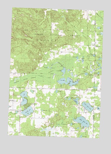
South Branch, MI USGS Topographic Map
Click on map above to begin viewing in our Map Viewer.

This topographic map contains these locations and features:
Feature Name Type Latitude Longitude GNIS ID View Map
Au Sable CreekStreamN44.4300°W83.9328°1619050View Map
Au Sable LakeLakeN44.4309°W83.9220°1619051View Map
Bass LakeLakeN44.4186°W83.9691°1619099View Map
Beanshuttle LakesLakeN44.4509°W83.9011°1619120View Map
Darlyn LakeLakeN44.4004°W83.9540°1619664View Map
Dollar LakeLakeN44.4376°W83.8958°1619732View Map
George LakeLakeN44.3988°W83.9737°1620008View Map
Goodar Township Volunteer Fire DepartmentBuildingN44.4644°W83.8860°2627029View Map
Guilford LakeLakeN44.4830°W83.8814°1620096View Map
Harper CreekStreamN44.4414°W83.8864°1620131View Map
Harper LakeLakeN44.4531°W83.9084°1620133View Map
Hill Township CemeteryCemeteryN44.3819°W83.8944°2503051View Map
Junior North HeliportAirportN44.4153°W83.9289°1624012View Map
La Barge LakeLakeN44.3842°W83.9042°1620463View Map
Lake AugustinaLakeN44.4110°W83.9080°1619061View Map
Little Au Sable LakeLakeN44.4400°W83.9264°1620528View Map
Maltby Post Office (historical)Post OfficeN44.4506°W83.9447°2503037View Map
Maltby Station (historical)LocaleN44.4514°W83.9431°2503028View Map
Maltbys SwampSwampN44.4381°W83.9480°1620676View Map
Mattson CreekStreamN44.4417°W83.8950°1620739View Map
Mink CreekStreamN44.4433°W83.9269°1620845View Map
Mink LakeLakeN44.4420°W83.9443°1620847View Map
Mud LakeLakeN44.4041°W83.8777°1620935View Map
Mud LakeLakeN44.4125°W83.9226°1620936View Map
No Mans LakeLakeN44.4124°W83.9177°1621016View Map
North Dease LakeLakeN44.4055°W83.8924°1621040View Map
O'Connor LakeLakeN44.3977°W83.9890°1621080View Map
Oak Grove CemeteryCemeteryN44.4789°W83.8864°1621082View Map
Peterson LakeLakeN44.4245°W83.8830°1621219View Map
Rat LakeLakeN44.4404°W83.9195°1621347View Map
Rifle LakeLakeN44.4086°W83.9798°1621390View Map
River LakesLakeN44.4511°W83.8797°1621396View Map
Rose Township District Number Five School Historical MarkerParkN44.4175°W83.9842°2503055View Map
Secord LakeLakeN44.4387°W83.8793°1621556View Map
Shady ShoresPopulated PlaceN44.4064°W83.9744°1621571View Map
South BranchPopulated PlaceN44.4667°W83.8889°1621678View Map
South Branch Post OfficePost OfficeN44.4667°W83.8889°2503004View Map
South Branch Station (historical)LocaleN44.4639°W83.8856°2503003View Map
South Dease LakeLakeN44.3907°W83.8988°1621699View Map
Thunder LakeLakeN44.3878°W83.9137°1621907View Map
Timbers Sky Camp AirportAirportN44.4681°W83.8848°1624157View Map
Township of GoodarCivilN44.4654°W83.9460°1626362View Map
Township of HillCivilN44.3783°W83.9442°1626472View Map
Trout LakeLakeN44.4424°W83.9483°1621960View Map
Valley LakeLakeN44.4194°W83.9353°1622011View Map
Welles LakeLakeN44.4559°W83.8859°1622079View Map

Note: Coordinates in the location and feature list above are referenced to NAD83 datum.


Copyright (C) 2008-2024 Ryan Niemi / Sunset Dynamics ... All Rights Reserved