TopoQuest Logo
Do you find TopoQuest useful?
Help keep TopoQuest running and adding new maps/features by donating!
Bitcoin:  19c7KJd3qBynnjoSw5npx9KScwjBe4ifkT
Litecoin:  LXs6TkuXGGXo1vDsWCkWVdjQX94eUKd6ui
Home View Maps Find Maps Find Places Resources & Links


Southington, Ohio Topographic Map

USGS Map Title: Southington, OH
USGS Map MRC: 41080C8
DRG (GeoTIFF) Download: o41080c8.tif


Neighboring USGS Topographic Map Quads:


  Middlefield, OH  
41081D1
 

  West Farmington, OH  
41080D8
 

  Bristolville, OH  
41080D7
 

  Garrettsville, OH  
41081C1
 

  Southington, OH  
41080C8
 

  Champion, OH  
41080C7
 

  Windham, OH  
41081B1
 

  Newton Falls, OH  
41080B8
 

  Warren, OH  
41080B7


Map MRC Location:

N42°
W81°
N42°
W80°
H8 H7 H6 H5 H4 H3 H2 H1
G8 G7 G6 G5 G4 G3 G2 G1
F8 F7 F6 F5 F4 F3 F2 F1
E8 E7 E6 E5 E4 E3 E2 E1
D8 D7 D6 D5 D4 D3 D2 D1
C8 C7 C6 C5 C4 C3 C2 C1
B8 B7 B6 B5 B4 B3 B2 B1
A8 A7 A6 A5 A4 A3 A2 A1
N41°
W81°
N41°
W80°

Southington, OH USGS 1:24K Topographic Map Preview:
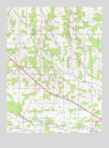
Southington, OH USGS Topographic Map
Click on map above to begin viewing in our Map Viewer.

This topographic map contains these locations and features:
Feature Name Type Latitude Longitude GNIS ID View Map
Baptist Hill CemeteryCemeteryN41.3425°W80.9847°1961519View Map
Beaver PondSwampN41.2720°W80.9820°1061992View Map
Chalker High SchoolSchoolN41.3095°W80.9579°1050731View Map
Chocolate RunStreamN41.2514°W80.8829°1066647View Map
DelightfulPopulated PlaceN41.2862°W80.9251°1064523View Map
Delightful CemeteryCemeteryN41.2846°W80.9214°1961526View Map
Delightful Evangelical Congregational ChurchChurchN41.2853°W80.9256°1062012View Map
Delightful Post Office (historical)Post OfficeN41.2862°W80.9248°2059968View Map
Eagle CreekStreamN41.2526°W80.8890°1066694View Map
Evergreen Mobile Home CourtPopulated PlaceN41.2919°W80.9494°2513492View Map
Forest Oaks Golf CourseLocaleN41.3212°W80.9706°1050728View Map
Herner CornersPopulated PlaceN41.3709°W80.9901°1065691View Map
Maltby CemeteryCemeteryN41.3411°W80.9334°1961538View Map
Mobile Haven ParkPopulated PlaceN41.2728°W80.8783°2513495View Map
Ohio State Highway Patrol - Warren Patrol PostBuildingN41.2837°W80.9207°2733096View Map
PhalanxPopulated PlaceN41.2609°W80.9787°1062937View Map
Phalanx Post Office (historical)Post OfficeN41.2612°W80.9790°2060387View Map
Pleasant Park Mobile Home ParkPopulated PlaceN41.2647°W80.8856°2513488View Map
Reform CemeteryCemeteryN41.3089°W80.9298°1044923View Map
ShiholdPopulated PlaceN41.2603°W80.9548°1062571View Map
SouthingtonPopulated PlaceN41.3084°W80.9559°1065360View Map
Southington Center CemeteryCemeteryN41.3078°W80.9529°1961550View Map
Southington Elementary SchoolSchoolN41.3087°W80.9590°1050729View Map
Southington EstatesPopulated PlaceN41.2967°W80.9658°2513469View Map
Southington Middle SchoolSchoolN41.3089°W80.9579°1050730View Map
Southington Volunteer Fire DepartmentBuildingN41.3082°W80.9550°2549836View Map
State RoadPopulated PlaceN41.3003°W80.8979°1062577View Map
State Road Post Office (historical)Post OfficeN41.3001°W80.8984°2056300View Map
StroupsPopulated PlaceN41.3392°W80.9354°1065397View Map
Tinker CreekStreamN41.2695°W80.9820°1037295View Map
Township of SouthingtonCivilN41.3101°W80.9544°1087043View Map
Valley LakeLakeN41.3042°W80.9454°1047403View Map
Warren AirportAirportN41.2701°W80.9273°1083090View Map
Wassie (historical)Populated PlaceN41.3481°W80.8981°1061999View Map
Wassie Post OfficePost OfficeN41.3487°W80.8984°2062023View Map

Note: Coordinates in the location and feature list above are referenced to NAD83 datum.


Copyright (C) 2008-2025 Ryan Niemi / Sunset Dynamics ... All Rights Reserved