TopoQuest Logo
Do you find TopoQuest useful?
Help keep TopoQuest running and adding new maps/features by donating!
Bitcoin:  19c7KJd3qBynnjoSw5npx9KScwjBe4ifkT
Litecoin:  LXs6TkuXGGXo1vDsWCkWVdjQX94eUKd6ui
Home View Maps Find Maps Find Places Resources & Links


Southwest Lumberton, North Carolina Topographic Map

USGS Map Title: Southwest Lumberton, NC
USGS Map MRC: 34079E1
DRG (GeoTIFF) Download: o34079e1.tif


Neighboring USGS Topographic Map Quads:


  Pembroke, NC  
34079F2
 

  Northwest Lumberton, NC  
34079F1
 

  Northeast Lumberton, NC  
34078F8
 

  McDonald, NC  
34079E2
 

  Southwest Lumberton, NC  
34079E1
 

  Southeast Lumberton, NC  
34078E8
 

  Gaddysville, NC  
34079D2
 

  Fairmont, NC  
34079D1
 

  Evergreen, NC  
34078D8


Map MRC Location:

N35°
W80°
N35°
W79°
H8 H7 H6 H5 H4 H3 H2 H1
G8 G7 G6 G5 G4 G3 G2 G1
F8 F7 F6 F5 F4 F3 F2 F1
E8 E7 E6 E5 E4 E3 E2 E1
D8 D7 D6 D5 D4 D3 D2 D1
C8 C7 C6 C5 C4 C3 C2 C1
B8 B7 B6 B5 B4 B3 B2 B1
A8 A7 A6 A5 A4 A3 A2 A1
N34°
W80°
N34°
W79°

Southwest Lumberton, NC USGS 1:24K Topographic Map Preview:
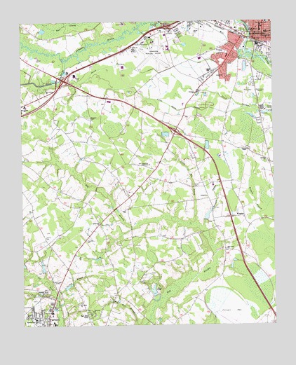
Southwest Lumberton, NC USGS Topographic Map
Click on map above to begin viewing in our Map Viewer.

This topographic map contains these locations and features:
Feature Name Type Latitude Longitude GNIS ID View Map
Back SwampStreamN34.6096°W79.1011°980417View Map
Back Swamp ChurchChurchN34.5971°W79.1123°980418View Map
Bear SwampStreamN34.6166°W79.0842°980734View Map
Brittland Mobile Home ParkPopulated PlaceN34.5552°W79.0005°2505420View Map
Centerville ChurchChurchN34.5427°W79.0867°982947View Map
Cotton Mill BranchStreamN34.6104°W79.0148°983595View Map
Davis CemeteryCemeteryN34.5568°W79.0395°983988View Map
East Side ParkPopulated PlaceN34.5043°W79.0931°1020091View Map
Fairmont Northside Church of GodChurchN34.5143°W79.1143°2505886View Map
Fairpoint Free Will Baptist ChurchChurchN34.5087°W79.1206°2505887View Map
Floyd Memorial CemeteryCemeteryN34.5124°W79.1175°985249View Map
Greenville Missionary ChurchChurchN34.5663°W79.0650°986120View Map
Gum Branch CanalCanalN34.6082°W79.0261°986212View Map
Hilly Branch SchoolSchoolN34.5904°W79.1231°986841View Map
Hog Swamp ChurchChurchN34.5313°W79.0234°986895View Map
Horsepen BranchStreamN34.5399°W79.0348°987125View Map
Interstate 95 - US Highway 74 Biggs Industrial ParkLocaleN34.5993°W79.0561°2505178View Map
Interstate 95 Air Park WestLocaleN34.6078°W79.0740°2505176View Map
Interstate 95 King Industrial ParkLocaleN34.6143°W79.0405°2505177View Map
Jacks BranchStreamN34.6238°W79.0703°987477View Map
Jenkins CemeteryCemeteryN34.5365°W79.1136°987550View Map
Joe P Moore SchoolSchoolN34.6229°W79.0053°987627View Map
Juniper BaySwampN34.5049°W79.0214°987831View Map
Kersey BranchStreamN34.6246°W79.0970°987941View Map
KingdalePopulated PlaceN34.5446°W79.0145°1021048View Map
Lewis CemeteryCemeteryN34.5477°W79.0742°988382View Map
Liberty Hill ChurchChurchN34.6029°W79.0261°988432View Map
Little Hog SwampSwampN34.5591°W79.0400°988663View Map
Little Jacob SwampStreamN34.5899°W79.0136°988679View Map
LumbertonPopulated PlaceN34.6182°W79.0086°989128View Map
Lumberton Correctional InstituteBuildingN34.5870°W79.0548°2505311View Map
Lumberton Fire DepartmentBuildingN34.6212°W79.0033°2638499View Map
Lumberton Fire Department Station 3BuildingN34.6192°W79.0389°2639803View Map
Lumberton Junior High SchoolSchoolN34.6047°W79.0313°1006785View Map
Lumberton Police Department South SubstationBuildingN34.6114°W79.0211°2769784View Map
Lumberton Police Department West SubstationBuildingN34.6229°W79.0410°2769780View Map
Lumberton Post OfficePost OfficeN34.6220°W79.0052°2774061View Map
Lumberton Regional AirportAirportN34.6139°W79.0601°997853View Map
McNeils BridgeBridgeN34.6241°W79.0573°989642View Map
Mount Carmel ChurchChurchN34.5091°W79.0959°990345View Map
Mount Haven ChurchChurchN34.6141°W79.0706°990393View Map
Newport ChurchChurchN34.5954°W79.0384°991132View Map
Northside ChurchChurchN34.5143°W79.1142°991299View Map
Oak Grove ChurchChurchN34.5063°W79.0903°991357View Map
Old Field SwampSwampN34.5210°W79.1195°991558View Map
Pine Terrace Volunteer Fire DepartmentBuildingN34.5990°W79.0091°2638325View Map
Prevatte CemeteryCemeteryN34.5352°W79.0931°992799View Map
Robeson County Emergency Medical ServicesBuildingN34.5864°W79.0530°2720705View Map
Robeson County Public LibraryBuildingN34.6175°W79.0080°2505962View Map
Robeson County Search and Rescue TeamBuildingN34.6227°W79.0091°2720467View Map
Robeson County Sheriff's OfficeBuildingN34.5852°W79.0523°2769630View Map
Rosenwald SchoolSchoolN34.5021°W79.1192°1027451View Map
Saint Francis DeSales SchoolSchoolN34.6193°W79.0028°993891View Map
Sandhill ChurchChurchN34.5679°W79.0034°994248View Map
Scarborough Lake Number OneReservoirN34.5147°W79.0599°998097View Map
Scarborough Lake Number One DamDamN34.5135°W79.0598°998098View Map
Smyrna ChurchChurchN34.5532°W79.0328°995025View Map
Smyrna Township Volunteer Fire DepartmentBuildingN34.5415°W79.0297°2639439View Map
Thompson ChapelChurchN34.5729°W79.0131°996049View Map
Thompson ChapelChurchN34.5857°W79.0909°996050View Map
Township of Back SwampCivilN34.5854°W79.1147°1027102View Map
Township of SmyrnaCivilN34.5450°W79.0378°1027124View Map
Turkey BranchStreamN34.5127°W79.1081°996313View Map
W H Knuckles Elementary SchoolSchoolN34.6108°W79.0220°1006786View Map
WAGR-AM (Lumberton)TowerN34.5996°W79.0089°1018361View Map
West Lumberton Elementary SchoolSchoolN34.6229°W79.0345°1006787View Map
WFMO-AM (Fairmont)TowerN34.5177°W79.1050°1018359View Map
WJSK-FM (Lumberton)TowerN34.5996°W79.0089°1018618View Map
WZYZ-FM (Fairmont)TowerN34.5177°W79.1050°1018617View Map

Note: Coordinates in the location and feature list above are referenced to NAD83 datum.


Copyright (C) 2008-2025 Ryan Niemi / Sunset Dynamics ... All Rights Reserved