TopoQuest Logo
Do you find TopoQuest useful?
Help keep TopoQuest running and adding new maps/features by donating!
Bitcoin:  19c7KJd3qBynnjoSw5npx9KScwjBe4ifkT
Litecoin:  LXs6TkuXGGXo1vDsWCkWVdjQX94eUKd6ui
Home View Maps Find Maps Find Places Resources & Links


Gaddysville, North Carolina Topographic Map

USGS Map Title: Gaddysville, NC
USGS Map MRC: 34079D2
DRG (GeoTIFF) Download: o34079d2.tif


Neighboring USGS Topographic Map Quads:


  Rowland, NC  
34079E3
 

  McDonald, NC  
34079E2
 

  Southwest Lumberton, NC  
34079E1
 

  Dillon East, SC  
34079D3
 

  Gaddysville, NC  
34079D2
 

  Fairmont, NC  
34079D1
 

  Fork, SC  
34079C3
 

  Lake View, SC  
34079C2
 

  Fair Bluff, NC  
34079C1


Map MRC Location:

N35°
W80°
N35°
W79°
H8 H7 H6 H5 H4 H3 H2 H1
G8 G7 G6 G5 G4 G3 G2 G1
F8 F7 F6 F5 F4 F3 F2 F1
E8 E7 E6 E5 E4 E3 E2 E1
D8 D7 D6 D5 D4 D3 D2 D1
C8 C7 C6 C5 C4 C3 C2 C1
B8 B7 B6 B5 B4 B3 B2 B1
A8 A7 A6 A5 A4 A3 A2 A1
N34°
W80°
N34°
W79°

Gaddysville, NC USGS 1:24K Topographic Map Preview:
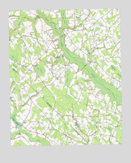
Gaddysville, NC USGS Topographic Map
Click on map above to begin viewing in our Map Viewer.

This topographic map contains these locations and features:
Feature Name Type Latitude Longitude GNIS ID View Map
Arnette CemeteryCemeteryN34.3896°W79.2067°1220238View Map
Baltimore ChurchChurchN34.4810°W79.1570°980509View Map
Bass CemeteryCemeteryN34.4060°W79.1514°980600View Map
Bass CemeteryCemeteryN34.4046°W79.1328°1023452View Map
Beaverdam CreekStreamN34.4077°W79.2409°980833View Map
Beaverdam CreekStreamN34.3902°W79.2384°1220438View Map
Big BranchStreamN34.4129°W79.1259°981320View Map
Brewer CemeteryCemeteryN34.4338°W79.1617°981854View Map
Britt CemeteryCemeteryN34.4571°W79.1959°981919View Map
Bullock CemeteryCemeteryN34.3777°W79.1823°1221118View Map
Bullock CemeteryCemeteryN34.4635°W79.2070°982231View Map
Bullock CemeteryCemeteryN34.4813°W79.1667°982233View Map
Bullock CemeteryCemeteryN34.4849°W79.1459°982235View Map
Butler BaySwampN34.4563°W79.2445°982329View Map
Butler CemeteryCemeteryN34.4657°W79.2306°982333View Map
Byrd CemeteryCemeteryN34.3940°W79.1548°982364View Map
Canaan BranchStreamN34.4007°W79.2498°1245696View Map
Canaan School (historical)SchoolN34.4291°W79.2442°1236082View Map
Colen Williams BaySwampN34.4460°W79.1345°983365View Map
Cowford SwampStreamN34.4932°W79.2339°983650View Map
Cowpen SwampStreamN34.4135°W79.1798°1221798View Map
Curtis CemeteryCemeteryN34.4196°W79.2492°1221881View Map
Davis CemeteryCemeteryN34.4593°W79.1609°983987View Map
Evans CemeteryCemeteryN34.3913°W79.1500°984856View Map
Fairgrove SchoolSchoolN34.4929°W79.1736°984904View Map
Fairview ChurchChurchN34.4952°W79.1331°984913View Map
Faulk CemeteryCemeteryN34.4410°W79.1750°985017View Map
Five ForksPopulated PlaceN34.4716°W79.2003°985126View Map
Five Forks ChurchChurchN34.4485°W79.1842°985129View Map
Ford CemeteryCemeteryN34.3835°W79.1553°985266View Map
Gaddy CemeteryCemeteryN34.4027°W79.1798°985512View Map
Gaddy CemeteryCemeteryN34.4621°W79.2081°985513View Map
Gaddys MillPopulated PlaceN34.3943°W79.2370°1236109View Map
Gaddys MillpondReservoirN34.3942°W79.2393°1222618View Map
Gaddys Millpond Dam D-3598DamN34.3938°W79.2387°1240073View Map
GaddysvillePopulated PlaceN34.4488°W79.2234°985515View Map
Grantham CemeteryCemeteryN34.4277°W79.2342°1222820View Map
Gully BaySwampN34.4493°W79.2439°986202View Map
Gully BranchStreamN34.4188°W79.2498°1222937View Map
Hammond CrossroadsPopulated PlaceN34.4752°W79.2353°1020601View Map
Harrington CemeteryCemeteryN34.4015°W79.1789°986439View Map
Hill CemeteryCemeteryN34.4202°W79.1473°986792View Map
Hill CemeteryCemeteryN34.4368°W79.1603°986793View Map
Horn Camp SwampStreamN34.4846°W79.1864°987061View Map
Horns MillraceStreamN34.4599°W79.1864°987074View Map
Horns Old MillpondReservoirN34.4564°W79.1917°987075View Map
Howard BaySwampN34.4371°W79.1845°987176View Map
Hunt CemeteryCemeteryN34.4415°W79.1986°987244View Map
Jones CemeteryCemeteryN34.4352°W79.2164°987718View Map
Lewis CemeteryCemeteryN34.4246°W79.1661°988378View Map
Little Cowpen BranchStreamN34.3821°W79.1631°988579View Map
McKenzie PondLakeN34.3966°W79.2350°1224412View Map
McLeod Mill BranchStreamN34.4963°W79.2142°989618View Map
Mill BaySwampN34.4446°W79.2162°989856View Map
Mill BranchStreamN34.4485°W79.1620°989863View Map
Mill Branch ChurchChurchN34.4516°W79.1573°989893View Map
Miller CemeteryCemeteryN34.4477°W79.2306°989997View Map
Mitchell CemeteryCemeteryN34.4877°W79.1803°990090View Map
Morgan CemeteryCemeteryN34.3949°W79.1770°990223View Map
Morgan PondsLakeN34.3923°W79.1733°990235View Map
Mount Zion Baptist Church CemeteryCemeteryN34.4213°W79.2211°1964701View Map
Mount Zion ChurchChurchN34.4216°W79.2206°1224836View Map
Oakdale ChurchChurchN34.3946°W79.1523°991458View Map
Page ChapelChurchN34.4366°W79.1967°991784View Map
Piney Grove Baptist ChurchChurchN34.3863°W79.2392°1225496View Map
Piney Grove Baptist Church CemeteryCemeteryN34.3860°W79.2395°1964703View Map
Piney Grove Indian ChurchChurchN34.4521°W79.2103°992369View Map
Pittman PondReservoirN34.4825°W79.1649°2790943View Map
Pleasant Grove CemeteryCemeteryN34.4924°W79.2161°992458View Map
Poplar Creek ChurchChurchN34.3854°W79.1850°1250214View Map
Robeson County Sheriff's OfficeBuildingN34.3769°W79.1287°2130904View Map
Saint Pauls ChurchChurchN34.4018°W79.1837°994076View Map
Sanderson CemeteryCemeteryN34.4488°W79.2345°994243View Map
Shanty BaySwampN34.4385°W79.1267°994578View Map
South Robeson SchoolSchoolN34.3913°W79.1317°995209View Map
Townsend CemeteryCemeteryN34.4040°W79.1964°1227189View Map
Townsend CemeteryCemeteryN34.4482°W79.1856°996190View Map
Township of GaddysCivilN34.4516°W79.2128°1027107View Map
Township of WhitehouseCivilN34.3857°W79.1339°2407573View Map
Tupelo BaySwampN34.4204°W79.2139°996311View Map
Tupelo BaySwampN34.4118°W79.2131°1227226View Map
Union ChurchChurchN34.3927°W79.2431°1251258View Map
Union High School (historical)SchoolN34.3974°W79.2356°1251796View Map
Union School (historical)SchoolN34.3913°W79.2406°1248773View Map
Walters CemeteryCemeteryN34.4646°W79.1514°996757View Map
Wards StoreLocaleN34.4452°W79.2278°996788View Map
White PondPopulated PlaceN34.4377°W79.1959°997201View Map
Whitehouse Volunteer Fire DepartmentBuildingN34.3894°W79.1321°2638672View Map
Worley CemeteryCemeteryN34.4699°W79.1561°997637View Map

Note: Coordinates in the location and feature list above are referenced to NAD83 datum.


Copyright (C) 2008-2024 Ryan Niemi / Sunset Dynamics ... All Rights Reserved