TopoQuest Logo
Do you find TopoQuest useful?
Help keep TopoQuest running and adding new maps/features by donating!
Bitcoin:  19c7KJd3qBynnjoSw5npx9KScwjBe4ifkT
Litecoin:  LXs6TkuXGGXo1vDsWCkWVdjQX94eUKd6ui
Home View Maps Find Maps Find Places Resources & Links


Tates Bluff, Arkansas Topographic Map

USGS Map Title: Tates Bluff, AR
USGS Map MRC: 33092G8
DRG (GeoTIFF) Download: o33092g8.tif


Neighboring USGS Topographic Map Quads:


  Curtis, AR  
33093H1
 

  Sparkman NW, AR  
33092H8
 

  Sparkman, AR  
33092H7
 

  Reader, AR  
33093G1
 

  Tates Bluff, AR  
33092G8
 

  Ouachita, AR  
33092G7
 

  Chidester, AR  
33093F1
 

  Bragg City, AR  
33092F8
 

  Harmony Grove, AR  
33092F7


Map MRC Location:

N34°
W93°
N34°
W92°
H8 H7 H6 H5 H4 H3 H2 H1
G8 G7 G6 G5 G4 G3 G2 G1
F8 F7 F6 F5 F4 F3 F2 F1
E8 E7 E6 E5 E4 E3 E2 E1
D8 D7 D6 D5 D4 D3 D2 D1
C8 C7 C6 C5 C4 C3 C2 C1
B8 B7 B6 B5 B4 B3 B2 B1
A8 A7 A6 A5 A4 A3 A2 A1
N33°
W93°
N33°
W92°

Tates Bluff, AR USGS 1:24K Topographic Map Preview:
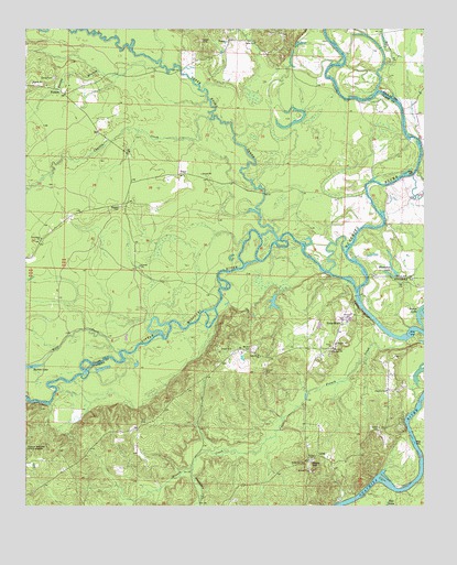
Tates Bluff, AR USGS Topographic Map
Click on map above to begin viewing in our Map Viewer.

This topographic map contains these locations and features:
Feature Name Type Latitude Longitude GNIS ID View Map
Bacon LakeLakeN33.8002°W92.8752°75631View Map
Barton LakeLakeN33.7867°W92.9980°75634View Map
Beaver CreekStreamN33.8587°W92.8902°46265View Map
Brushy CreekStreamN33.8379°W92.8777°76444View Map
Church of GodChurchN33.7804°W92.8868°64369View Map
Cypress CreekStreamN33.8512°W92.9429°48304View Map
Easley BranchStreamN33.8654°W92.9582°48744View Map
Easley CemeteryCemeteryN33.8623°W92.9910°48745View Map
French CreekStreamN33.7934°W92.8807°76977View Map
Hamilton CreekStreamN33.7593°W92.9482°49802View Map
Hill CemeteryCemeteryN33.7723°W92.9624°50111View Map
Horseshoe LakeLakeN33.8108°W92.8859°75739View Map
KansasPopulated PlaceN33.8582°W92.9882°57073View Map
Kansas CemeteryCemeteryN33.8287°W92.9707°50768View Map
Kansas Community Volunteer Fire DepartmentBuildingN33.8604°W92.9967°2116660View Map
Little Missouri RiverStreamN33.8084°W92.9002°77521View Map
LunetPopulated PlaceN33.7634°W92.9088°58103View Map
McGill CemeteryCemeteryN33.7912°W92.9299°51843View Map
Providence ChurchChurchN33.8201°W92.9954°53826View Map
Rocky HillSummitN33.7623°W92.9110°58510View Map
Rocky Hill ChurchChurchN33.7615°W92.9129°54140View Map
Rucks LandingLocaleN33.8459°W92.8766°70274View Map
Tates BluffPopulated PlaceN33.7990°W92.9010°57203View Map
Tates BluffCliffN33.8015°W92.8952°55447View Map
Tates Bluff ChurchChurchN33.7893°W92.9268°55448View Map
Terre Noire CreekStreamN33.8198°W92.9210°78539View Map
TracePopulated PlaceN33.8370°W92.9521°57213View Map
Union ChurchChurchN33.7918°W92.9038°55799View Map
VadenPopulated PlaceN33.8720°W92.9371°57218View Map
Vaden CemeteryCemeteryN33.8720°W92.9457°55868View Map
Vaden ChurchChurchN33.8715°W92.9285°55869View Map
Wolf CreekStreamN33.7904°W92.9710°56482View Map

Note: Coordinates in the location and feature list above are referenced to NAD83 datum.


Copyright (C) 2008-2025 Ryan Niemi / Sunset Dynamics ... All Rights Reserved