TopoQuest Logo
Do you find TopoQuest useful?
Help keep TopoQuest running and adding new maps/features by donating!
Bitcoin:  19c7KJd3qBynnjoSw5npx9KScwjBe4ifkT
Litecoin:  LXs6TkuXGGXo1vDsWCkWVdjQX94eUKd6ui
Home View Maps Find Maps Find Places Resources & Links


Splendora, Texas Topographic Map

USGS Map Title: Splendora, TX
USGS Map MRC: 30095B2
DRG (GeoTIFF) Download: o30095b2.tif


Neighboring USGS Topographic Map Quads:


  Cut And Shoot, TX  
30095C3
 

  Fostoria, TX  
30095C2
 

  Cleveland, TX  
30095C1
 

  Outlaw Pond, TX  
30095B3
 

  Splendora, TX  
30095B2
 

  Plum Grove, TX  
30095B1
 

  Maedan, TX  
30095A3
 

  Moonshine Hill, TX  
30095A2
 

  Huffman, TX  
30095A1


Map MRC Location:

N31°
W96°
N31°
W95°
H8 H7 H6 H5 H4 H3 H2 H1
G8 G7 G6 G5 G4 G3 G2 G1
F8 F7 F6 F5 F4 F3 F2 F1
E8 E7 E6 E5 E4 E3 E2 E1
D8 D7 D6 D5 D4 D3 D2 D1
C8 C7 C6 C5 C4 C3 C2 C1
B8 B7 B6 B5 B4 B3 B2 B1
A8 A7 A6 A5 A4 A3 A2 A1
N30°
W96°
N30°
W95°

Splendora, TX USGS 1:24K Topographic Map Preview:
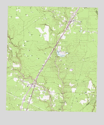
Splendora, TX USGS Topographic Map
Click on map above to begin viewing in our Map Viewer.

This topographic map contains these locations and features:
Feature Name Type Latitude Longitude GNIS ID View Map
A M Aikin Elementary SchoolSchoolN30.1788°W95.1552°2007462View Map
Big Carter PondSwampN30.1622°W95.1516°1330579View Map
Big Dinah PondSwampN30.2032°W95.2279°1330590View Map
Briar Patch PondLakeN30.1318°W95.2344°1331250View Map
Button Willow PondSwampN30.2492°W95.1462°1331763View Map
Carver SchoolSchoolN30.1424°W95.2163°1332251View Map
Casey GullyValleyN30.1480°W95.1253°1332281View Map
Casey PondSwampN30.1461°W95.1471°1332283View Map
Cat PondSwampN30.1377°W95.1528°1332319View Map
Church House GullyValleyN30.1327°W95.1297°1332828View Map
City of Patton VillageCivilN30.1956°W95.1696°2411385View Map
City of SplendoraCivilN30.2325°W95.1616°2411954View Map
City of WoodbranchCivilN30.1814°W95.1834°2412295View Map
Coleman LakeLakeN30.2203°W95.1485°1333095View Map
Convict PondSwampN30.1878°W95.2083°1333258View Map
Country Baptist ChurchChurchN30.1392°W95.2416°2470768View Map
Countryside United Methodist ChurchChurchN30.2330°W95.1630°2023067View Map
Creed PondSwampN30.1417°W95.1543°1333644View Map
Deer PondLakeN30.2285°W95.1524°1334220View Map
DeerbrookPopulated PlaceN30.2117°W95.1660°2471906View Map
Dry CreekStreamN30.1722°W95.2322°1334674View Map
Duck PondSwampN30.1910°W95.2229°1334720View Map
Duke PondSwampN30.2395°W95.2234°1334751View Map
East River ChurchChurchN30.1480°W95.1410°1334980View Map
First Baptist Church of Patton LakesChurchN30.2033°W95.1799°2023159View Map
Forest EstatesPopulated PlaceN30.2299°W95.1811°2471943View Map
Forestwood Baptist ChurchChurchN30.1755°W95.1652°2023161View Map
Grace Lutheran ChurchChurchN30.1447°W95.2194°2023063View Map
Grassy PondSwampN30.1769°W95.1683°1336856View Map
Gulley BranchStreamN30.2285°W95.1702°1337111View Map
Hayden PondLakeN30.2322°W95.1499°1337491View Map
Hill and Dale TerracePopulated PlaceN30.2128°W95.1543°2472030View Map
Hog PondSwampN30.2483°W95.2365°1337908View Map
Houston and Harris County CampLocaleN30.1369°W95.1691°1338171View Map
Island PondSwampN30.2155°W95.2035°1338515View Map
KeeferPopulated PlaceN30.1799°W95.1985°1378515View Map
Keefer PondSwampN30.1937°W95.1964°1338976View Map
Kid CemeteryCemeteryN30.1608°W95.2277°1339089View Map
Lake Houston State ParkParkN30.1294°W95.1680°2028978View Map
Lake SpendoraPopulated PlaceN30.2358°W95.1843°2472069View Map
Lakeland LakeLakeN30.1919°W95.1724°1339532View Map
Lakeland Lake DamDamN30.1919°W95.1735°1863593View Map
Line PondSwampN30.1713°W95.1488°1339974View Map
Little Carter PondSwampN30.1616°W95.1455°1340046View Map
Little Dinah PondSwampN30.2074°W95.2253°1340080View Map
Long PondLakeN30.1976°W95.2206°1340507View Map
Mare BranchStreamN30.1999°W95.1844°1340939View Map
Mizell CemeteryCemeteryN30.2247°W95.1666°1341776View Map
Montgomery County Constable's Office Precinct 4BuildingN30.1398°W95.2272°2751343View Map
Montgomery County Hospital District Emergency Medical Services Station 51BuildingN30.1590°W95.2288°2720919View Map
Montgomery County Hospital District Emergency Medical Services Station 52BuildingN30.2393°W95.1590°2720918View Map
Montgomery County Sheriff's Office - Patrol District 3BuildingN30.1398°W95.2271°2751498View Map
Mule PondSwampN30.1922°W95.2255°1342256View Map
New CaneyPopulated PlaceN30.1552°W95.2113°1342442View Map
New Caney Fire Department Central Station 151BuildingN30.1591°W95.2289°2334616View Map
New Caney Fire Department Substation 152BuildingN30.1733°W95.1925°2334617View Map
New Caney Fire Department Substation 153BuildingN30.1464°W95.1335°2334618View Map
New Caney Independent School District Police DepartmentBuildingN30.1429°W95.2163°2375827View Map
New Caney Post OfficePost OfficeN30.1450°W95.2214°2731881View Map
Patton LakeLakeN30.1949°W95.1670°1343689View Map
Patton VillagePopulated PlaceN30.1930°W95.1688°1388598View Map
Patton Village City HallBuildingN30.1974°W95.1768°2753876View Map
Patton Village Lake DamDamN30.1935°W95.1685°1854397View Map
Patton Village Police DepartmentBuildingN30.1975°W95.1769°2375946View Map
Peach Creek DamDamN30.1919°W95.1785°1854399View Map
Peach Creek LakeLakeN30.1940°W95.1789°1343718View Map
Pine PondLakeN30.1754°W95.1612°1344069View Map
Presswood PondSwampN30.2160°W95.2189°1344549View Map
Robinson CemeteryCemeteryN30.1460°W95.1991°1345332View Map
Roman ForestPopulated PlaceN30.1791°W95.1624°1388597View Map
Roman Forest City HallBuildingN30.1786°W95.1631°2753594View Map
Roman Forest Police DepartmentBuildingN30.1787°W95.1631°2375903View Map
Round PondSwampN30.1912°W95.2173°1345689View Map
Sand PondSwampN30.1872°W95.1757°1346531View Map
Section PondSwampN30.2427°W95.1549°1346870View Map
Skinner CemeteryCemeteryN30.1255°W95.1880°1347202View Map
Smith PondSwampN30.2368°W95.2470°1347287View Map
SplendoraPopulated PlaceN30.2330°W95.1610°1347662View Map
Splendora CemeteryCemeteryN30.2241°W95.1672°1347663View Map
Splendora City HallBuildingN30.2329°W95.1618°2470631View Map
Splendora Elementary SchoolSchoolN30.2327°W95.1630°2007408View Map
Splendora High SchoolSchoolN30.2470°W95.1980°2007409View Map
Splendora Intermediate SchoolSchoolN30.2333°W95.1594°2007410View Map
Splendora Middle SchoolSchoolN30.2335°W95.1622°2007411View Map
Splendora Oil FieldOilfieldN30.2074°W95.1724°1347664View Map
Splendora Police DepartmentBuildingN30.2327°W95.1604°2375941View Map
Splendora Post OfficePost OfficeN30.2326°W95.1593°2472502View Map
Splendora Volunteer Fire Department - First RespondersBuildingN30.2392°W95.1590°2334619View Map
Spring BranchStreamN30.1794°W95.2474°1383422View Map
Spring BranchStreamN30.1799°W95.2308°1347690View Map
The Lords Chapel ChurchChurchN30.2174°W95.1266°2023081View Map
Tie PondSwampN30.1816°W95.1708°1348553View Map
Town of Roman ForestCivilN30.1794°W95.1594°2412573View Map
Union EncampmentLocaleN30.1274°W95.1730°1349058View Map
Viney PondSwampN30.2057°W95.2275°1349296View Map
Waterhole BranchStreamN30.2172°W95.1810°1349540View Map
WoodbranchPopulated PlaceN30.1810°W95.1888°1388596View Map
Woodbranch Police DepartmentBuildingN30.1876°W95.1924°2375859View Map
Woodbranch Village OfficeBuildingN30.1876°W95.1924°2753241View Map

Note: Coordinates in the location and feature list above are referenced to NAD83 datum.


Copyright (C) 2008-2024 Ryan Niemi / Sunset Dynamics ... All Rights Reserved