TopoQuest Logo
Do you find TopoQuest useful?
Help keep TopoQuest running and adding new maps/features by donating!
Bitcoin:  19c7KJd3qBynnjoSw5npx9KScwjBe4ifkT
Litecoin:  LXs6TkuXGGXo1vDsWCkWVdjQX94eUKd6ui
Home View Maps Find Maps Find Places Resources & Links


Fostoria, Texas Topographic Map

USGS Map Title: Fostoria, TX
USGS Map MRC: 30095C2
DRG (GeoTIFF) Download: o30095c2.tif


Neighboring USGS Topographic Map Quads:


  Conroe NE, TX  
30095D3
 

  Bear Creek, TX  
30095D2
 

  Westcott, TX  
30095D1
 

  Cut And Shoot, TX  
30095C3
 

  Fostoria, TX  
30095C2
 

  Cleveland, TX  
30095C1
 

  Outlaw Pond, TX  
30095B3
 

  Splendora, TX  
30095B2
 

  Plum Grove, TX  
30095B1


Map MRC Location:

N31°
W96°
N31°
W95°
H8 H7 H6 H5 H4 H3 H2 H1
G8 G7 G6 G5 G4 G3 G2 G1
F8 F7 F6 F5 F4 F3 F2 F1
E8 E7 E6 E5 E4 E3 E2 E1
D8 D7 D6 D5 D4 D3 D2 D1
C8 C7 C6 C5 C4 C3 C2 C1
B8 B7 B6 B5 B4 B3 B2 B1
A8 A7 A6 A5 A4 A3 A2 A1
N30°
W96°
N30°
W95°

Fostoria, TX USGS 1:24K Topographic Map Preview:
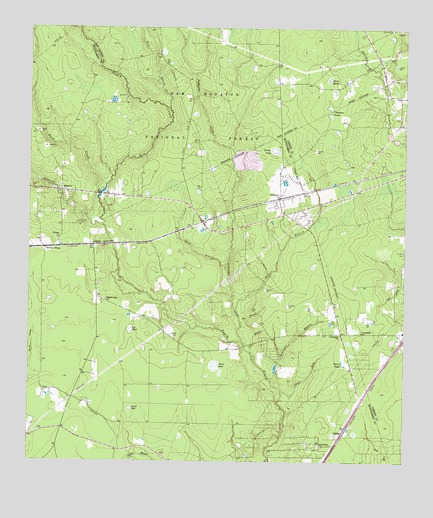
Fostoria, TX USGS Topographic Map
Click on map above to begin viewing in our Map Viewer.

This topographic map contains these locations and features:
Feature Name Type Latitude Longitude GNIS ID View Map
Bailey PondLakeN30.2791°W95.1451°1381184View Map
Bee BranchStreamN30.2941°W95.1808°1381185View Map
Big PondSwampN30.2887°W95.2164°1381188View Map
Cain BranchStreamN30.2816°W95.1755°1381195View Map
Calvary ChurchChurchN30.3141°W95.2402°1381196View Map
Chapman PondsLakeN30.3522°W95.1497°1381198View Map
Crossroads ChurchChurchN30.2869°W95.1460°1381204View Map
Crossroads ChurchChurchN30.2877°W95.1391°1381205View Map
Duck CreekStreamN30.3283°W95.2249°1383082View Map
East RiverPopulated PlaceN30.2788°W95.1335°1383226View Map
FostoriaPopulated PlaceN30.3263°W95.1663°1381210View Map
Friendship ChurchChurchN30.2555°W95.1524°1381211View Map
Grassy PondSwampN30.3400°W95.1689°1381215View Map
Gum BranchStreamN30.3522°W95.2027°1383098View Map
Hightower BranchStreamN30.2733°W95.1688°1381218View Map
Horse MarshSwampN30.3595°W95.1506°1381220View Map
Jayhawker CreekStreamN30.2847°W95.1783°1383113View Map
KJZS-FM (Conroe)TowerN30.3341°W95.2144°1387925View Map
KTFH-TV (Conroe)TowerN30.2627°W95.2474°1388110View Map
Lawrence CreekStreamN30.3180°W95.2249°1383123View Map
MidlinePopulated PlaceN30.2580°W95.1452°1381228View Map
Morgan CemeteryCemeteryN30.2866°W95.2022°1381231View Map
North ClevelandPopulated PlaceN30.3419°W95.1419°1384196View Map
Pilgrim Rest ChurchChurchN30.2966°W95.2241°1381242View Map
Pin Oak CemeteryCemeteryN30.3108°W95.1252°1381243View Map
Red BranchStreamN30.2891°W95.1788°1381248View Map
Round PondSwampN30.2652°W95.2162°1381250View Map
SecurityPopulated PlaceN30.3280°W95.2394°1381254View Map
Security Calvery Baptist ChurchChurchN30.3144°W95.2405°2023112View Map
Security CemeteryCemeteryN30.3185°W95.2333°1381255View Map
Security First Baptist ChurchChurchN30.3277°W95.2352°2023113View Map
Security SidingLocaleN30.3116°W95.2444°1381256View Map
Shady RunStreamN30.2702°W95.1658°1381258View Map
Shell BranchStreamN30.3066°W95.1841°1381259View Map
Splendora Fire Department Station 162BuildingN30.2852°W95.1728°2334620View Map
Splendora StadiumParkN30.2535°W95.2005°2027662View Map
TGP 25 HeliportAirportN30.3219°W95.1616°1386388View Map
United Baptist ChurchChurchN30.2679°W95.1395°2471306View Map
Ward PondSwampN30.2776°W95.1877°1381271View Map

Note: Coordinates in the location and feature list above are referenced to NAD83 datum.


Copyright (C) 2008-2025 Ryan Niemi / Sunset Dynamics ... All Rights Reserved