TopoQuest Logo
Do you find TopoQuest useful?
Help keep TopoQuest running and adding new maps/features by donating!
Bitcoin:  19c7KJd3qBynnjoSw5npx9KScwjBe4ifkT
Litecoin:  LXs6TkuXGGXo1vDsWCkWVdjQX94eUKd6ui
Home View Maps Find Maps Find Places Resources & Links


Spotted Mountain, Arizona Topographic Map

USGS Map Title: Spotted Mountain, AZ
USGS Map MRC: 34110A5
DRG (GeoTIFF) Download: o34110a5.tif


Neighboring USGS Topographic Map Quads:


  Chediski Peak, AZ  
34110B6
 

  Pepper Canyon, AZ  
34110B5
 

  Bear Ridge, AZ  
34110B4
 

  Oak Creek Ranch, AZ  
34110A6
 

  Spotted Mountain, AZ  
34110A5
 

  Cibecue, AZ  
34110A4
 

  Double Buttes, AZ  
33110H6
 

  Blue House Mountain, AZ  
33110H5
 

  Cibecue Peak, AZ  
33110H4


Map MRC Location:

N35°
W111°
N35°
W110°
H8 H7 H6 H5 H4 H3 H2 H1
G8 G7 G6 G5 G4 G3 G2 G1
F8 F7 F6 F5 F4 F3 F2 F1
E8 E7 E6 E5 E4 E3 E2 E1
D8 D7 D6 D5 D4 D3 D2 D1
C8 C7 C6 C5 C4 C3 C2 C1
B8 B7 B6 B5 B4 B3 B2 B1
A8 A7 A6 A5 A4 A3 A2 A1
N34°
W111°
N34°
W110°

Spotted Mountain, AZ USGS 1:24K Topographic Map Preview:
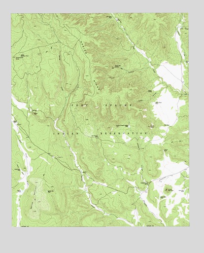
Spotted Mountain, AZ USGS Topographic Map
Click on map above to begin viewing in our Map Viewer.

This topographic map contains these locations and features:
Feature Name Type Latitude Longitude GNIS ID View Map
Airport TankReservoirN34.0446°W110.5187°534View Map
Caddo CanyonValleyN34.0820°W110.5157°2354View Map
Caddo PointCliffN34.0584°W110.5282°2355View Map
Caddo Point TankReservoirN34.0722°W110.5248°2356View Map
Cement Trough Canyon TankReservoirN34.0587°W110.5428°2678View Map
Cement Trough SpringSpringN34.0254°W110.5290°2679View Map
Cibecue CreekPopulated PlaceN34.0964°W110.5032°25317View Map
Double TankReservoirN34.0212°W110.6179°4061View Map
Grasshopper ButteSummitN34.0995°W110.6229°5298View Map
Henry SpringSpringN34.0792°W110.5298°5728View Map
Kelly DrawValleyN34.0309°W110.6165°6652View Map
Kelly Draw TankReservoirN34.0336°W110.6191°6653View Map
Lone Pine TankReservoirN34.0208°W110.5041°31213View Map
Lonely MountainSummitN34.0214°W110.5162°7318View Map
Lonely Mountain TankReservoirN34.0174°W110.5215°7319View Map
Lower Martinez TankReservoirN34.0997°W110.6191°7490View Map
M H TankReservoirN34.0593°W110.5141°7561View Map
Martinez RanchLocaleN34.0667°W110.6098°7747View Map
Red Canyon TankReservoirN34.0535°W110.5647°10024View Map
Salt Creek TankReservoirN34.1220°W110.5547°10752View Map
Spotted MountainSummitN34.0092°W110.6104°11689View Map
Spotted Mountain TankReservoirN34.0207°W110.6007°11690View Map
Spring RidgeRidgeN34.1150°W110.5871°11711View Map
Spring TankReservoirN34.0610°W110.6220°11712View Map
Truax CanyonValleyN34.0931°W110.5287°12736View Map
V Fortytwo SpringSpringN34.1212°W110.5520°13141View Map
Valley View CanyonValleyN34.1159°W110.5065°452View Map
Water Bag SpringSpringN34.0932°W110.5525°13375View Map

Note: Coordinates in the location and feature list above are referenced to NAD83 datum.


Copyright (C) 2008-2024 Ryan Niemi / Sunset Dynamics ... All Rights Reserved