TopoQuest Logo
Do you find TopoQuest useful?
Help keep TopoQuest running and adding new maps/features by donating!
Bitcoin:  19c7KJd3qBynnjoSw5npx9KScwjBe4ifkT
Litecoin:  LXs6TkuXGGXo1vDsWCkWVdjQX94eUKd6ui
Home View Maps Find Maps Find Places Resources & Links


Spring Arbor, Michigan Topographic Map

USGS Map Title: Spring Arbor, MI
USGS Map MRC: 42084B5
DRG (GeoTIFF) Download: o42084b5.tif


Neighboring USGS Topographic Map Quads:


  Northeast Albion, MI  
42084C6
 

  Parma, MI  
42084C5
 

  Jackson North, MI  
42084C4
 

  Southeast Albion, MI  
42084B6
 

  Spring Arbor, MI  
42084B5
 

  Jackson South, MI  
42084B4
 

  Mosherville, MI  
42084A6
 

  Hanover, MI  
42084A5
 

  Somerset Center, MI  
42084A4


Map MRC Location:

N43°
W85°
N43°
W84°
H8 H7 H6 H5 H4 H3 H2 H1
G8 G7 G6 G5 G4 G3 G2 G1
F8 F7 F6 F5 F4 F3 F2 F1
E8 E7 E6 E5 E4 E3 E2 E1
D8 D7 D6 D5 D4 D3 D2 D1
C8 C7 C6 C5 C4 C3 C2 C1
B8 B7 B6 B5 B4 B3 B2 B1
A8 A7 A6 A5 A4 A3 A2 A1
N42°
W85°
N42°
W84°

Spring Arbor, MI USGS 1:24K Topographic Map Preview:
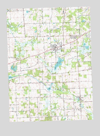
Spring Arbor, MI USGS Topographic Map
Click on map above to begin viewing in our Map Viewer.

This topographic map contains these locations and features:
Feature Name Type Latitude Longitude GNIS ID View Map
Arbor Manor Care CenterBuildingN42.2081°W84.5581°2632936View Map
Arbor Village Mobile Home CommunityPopulated PlaceN42.2282°W84.5533°2632955View Map
Bateman DrainCanalN42.2039°W84.5289°2112705View Map
Bean CemeteryCemeteryN42.2222°W84.5014°2633117View Map
Bean SchoolSchoolN42.2217°W84.5025°620819View Map
Chapman Welcome CenterBuildingN42.2056°W84.5539°2631441View Map
Cochran SchoolSchoolN42.1506°W84.5813°623529View Map
Cross LakeLakeN42.1603°W84.5619°624119View Map
Cross SchoolSchoolN42.1681°W84.5711°624121View Map
Crouch CemeteryCemeteryN42.1814°W84.5008°2633118View Map
Dewey ChurchChurchN42.1814°W84.6039°624617View Map
Dietzman HallSchoolN42.2072°W84.5542°2631446View Map
Dolbee Branch DrainCanalN42.2214°W84.5772°2112709View Map
Dunckel GymBuildingN42.2097°W84.5581°2631439View Map
Ed Cross Farm Historical MarkerParkN42.1973°W84.5536°2630757View Map
Fairview ChurchChurchN42.2328°W84.5811°2112711View Map
Gainey HallBuildingN42.2081°W84.5544°2631436View Map
Hanover Township Fire Department Station 2BuildingN42.1507°W84.5216°2636016View Map
Hilltop ChapelChurchN42.1931°W84.6108°2112704View Map
HortonPopulated PlaceN42.1503°W84.5172°628637View Map
Horton CemeteryCemeteryN42.1370°W84.5208°628638View Map
Horton Congregational ChurchChurchN42.1496°W84.5190°2632987View Map
Horton Mill Pond County ParkParkN42.1467°W84.5200°2632132View Map
Horton Post OfficePost OfficeN42.1506°W84.5224°2632985View Map
Horton Station (historical)LocaleN42.1431°W84.5183°2632984View Map
Huron Potawatomi Village Historical MarkerParkN42.1882°W84.5781°2630758View Map
Jackson District Library-Spring Arbor BranchBuildingN42.2049°W84.5534°2632565View Map
Kresge Student CenterBuildingN42.2072°W84.5556°2631447View Map
KTGG-AM (Spring Arbor)TowerN42.1537°W84.5494°1625303View Map
Leidley CemeteryCemeteryN42.1503°W84.5681°2112700View Map
Lime LakeLakeN42.1878°W84.5483°630423View Map
Lime Lake County ParkParkN42.1869°W84.5556°2632134View Map
Lowell HallBuildingN42.2081°W84.5556°2631438View Map
Luttenon SchoolSchoolN42.1406°W84.6125°631223View Map
Luttenton CemeteryCemeteryN42.1361°W84.6142°2112701View Map
Miller Trailer VillagePopulated PlaceN42.2106°W84.5411°2632935View Map
Mitchell DrainCanalN42.1389°W84.5256°2112699View Map
Muffitt HallBuildingN42.2067°W84.5544°2631452View Map
Ormston HallBuildingN42.2067°W84.5536°2631453View Map
Pardee SchoolSchoolN42.1756°W84.5441°634358View Map
Parrott SchoolSchoolN42.1373°W84.5419°634428View Map
Pretty Branch DrainCanalN42.2117°W84.5703°2112708View Map
Reynolds LakeLakeN42.1842°W84.6162°2112703View Map
Reynolds SchoolSchoolN42.1811°W84.5005°635827View Map
Sayre Decan HallSchoolN42.2058°W84.5542°2631443View Map
Shining Light ChurchChurchN42.1811°W84.5008°2112702View Map
Smith Music CenterSchoolN42.2058°W84.5544°2631445View Map
Snyder Post Office (historical)Post OfficeN42.1958°W84.5203°2633073View Map
Snyder SchoolSchoolN42.2178°W84.5591°638224View Map
Snyder Station (historical)LocaleN42.1958°W84.5203°2631463View Map
Spring ArborPopulated PlaceN42.2050°W84.5527°638533View Map
Spring Arbor CemeteryCemeteryN42.2078°W84.5503°2633116View Map
Spring Arbor Census Designated PlaceCensusN42.2055°W84.5551°2393245View Map
Spring Arbor College Historical MarkerParkN42.2061°W84.5521°2630760View Map
Spring Arbor Free Methodist ChurchChurchN42.2061°W84.5528°2632934View Map
Spring Arbor Historical MarkerParkN42.1882°W84.5781°2630759View Map
Spring Arbor LakesLakeN42.2051°W84.5062°638534View Map
Spring Arbor Post OfficePost OfficeN42.2045°W84.5534°2632932View Map
Spring Arbor Station (historical)LocaleN42.1856°W84.5597°2632937View Map
Spring Arbor Township Fire DepartmentBuildingN42.2044°W84.5530°2635981View Map
Spring Arbor Township Police DepartmentBuildingN42.2044°W84.5530°2632933View Map
Spring Arbor UniversitySchoolN42.2058°W84.5539°2112706View Map
Spring Brook DrainCanalN42.2167°W84.6139°2112712View Map
The Kings ChapelChurchN42.2189°W84.5633°2112710View Map
Township of Spring ArborCivilN42.2039°W84.5397°1627106View Map
Voller HouseBuildingN42.2075°W84.5581°2631437View Map
Warner Elementary SchoolSchoolN42.2047°W84.5500°2632564View Map
Wellman General Store Historical MarkerParkN42.1502°W84.5213°2630744View Map
Western High SchoolSchoolN42.2444°W84.5394°2112707View Map
White AuditoriumBuildingN42.2058°W84.5536°2631442View Map
White LibraryBuildingN42.2064°W84.5556°2631448View Map
Whiteman Gibbs Science CenterSchoolN42.2061°W84.5556°2631440View Map
WSAE-FM (Spring Arbor)TowerN42.1537°W84.5494°1625503View Map

Note: Coordinates in the location and feature list above are referenced to NAD83 datum.


Copyright (C) 2008-2025 Ryan Niemi / Sunset Dynamics ... All Rights Reserved