TopoQuest Logo
Do you find TopoQuest useful?
Help keep TopoQuest running and adding new maps/features by donating!
Bitcoin:  19c7KJd3qBynnjoSw5npx9KScwjBe4ifkT
Litecoin:  LXs6TkuXGGXo1vDsWCkWVdjQX94eUKd6ui
Home View Maps Find Maps Find Places Resources & Links


Somerset Center, Michigan Topographic Map

USGS Map Title: Somerset Center, MI
USGS Map MRC: 42084A4
DRG (GeoTIFF) Download: o42084a4.tif


Neighboring USGS Topographic Map Quads:


  Spring Arbor, MI  
42084B5
 

  Jackson South, MI  
42084B4
 

  Michigan Center, MI  
42084B3
 

  Hanover, MI  
42084A5
 

  Somerset Center, MI  
42084A4
 

  Cement City, MI  
42084A3
 

  North Adams, MI  
41084H5
 

  Wheatland, MI  
41084H4
 

  Addison, MI  
41084H3


Map MRC Location:

N43°
W85°
N43°
W84°
H8 H7 H6 H5 H4 H3 H2 H1
G8 G7 G6 G5 G4 G3 G2 G1
F8 F7 F6 F5 F4 F3 F2 F1
E8 E7 E6 E5 E4 E3 E2 E1
D8 D7 D6 D5 D4 D3 D2 D1
C8 C7 C6 C5 C4 C3 C2 C1
B8 B7 B6 B5 B4 B3 B2 B1
A8 A7 A6 A5 A4 A3 A2 A1
N42°
W85°
N42°
W84°

Somerset Center, MI USGS 1:24K Topographic Map Preview:
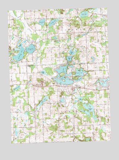
Somerset Center, MI USGS Topographic Map
Click on map above to begin viewing in our Map Viewer.

This topographic map contains these locations and features:
Feature Name Type Latitude Longitude GNIS ID View Map
Aldrich CemeteryCemeteryN42.0045°W84.4208°619927View Map
Bakers Post OfficePost OfficeN42.0222°W84.4403°2418324View Map
Bankers Station (historical)LocaleN42.0222°W84.4403°2418325View Map
Blood LakeLakeN42.0381°W84.4177°621606View Map
Braxee LakeLakeN42.0659°W84.4575°621907View Map
Brooks Cemetery (historical)CemeteryN42.0539°W84.4703°2419733View Map
Bunday HillSummitN42.0548°W84.4583°622252View Map
Butcher Farm Cemetery (historical)CemeteryN42.0222°W84.4403°2419734View Map
Crego Cemetery (historical)CemeteryN42.0667°W84.4583°2419732View Map
Crispell LakeLakeN42.1128°W84.4434°624067View Map
Crystal LakeLakeN42.0642°W84.4119°624171View Map
Deer Run Golf ClubLocaleN42.0953°W84.4672°1623310View Map
East Liberty CemeteryCemeteryN42.1180°W84.3775°2633103View Map
East Liberty ChurchChurchN42.1181°W84.3766°625227View Map
Farewell LakeLakeN42.0835°W84.4863°625824View Map
Fox LakeLakeN42.0875°W84.4899°626375View Map
Gambleville CemeteryCemeteryN42.0430°W84.3806°2419728View Map
Gay CemeteryCemeteryN42.0472°W84.3917°2418469View Map
Goose LakeLakeN42.0395°W84.4583°626965View Map
Grace Baptist ChurchChurchN42.0517°W84.4158°2419701View Map
Grand LakeLakeN42.0842°W84.4216°627089View Map
Hinman LakeLakeN42.0843°W84.4990°628346View Map
JeromePopulated PlaceN42.0270°W84.4694°629265View Map
Jerome Post OfficePost OfficeN42.0269°W84.4694°2419705View Map
Jerome Station (historical)LocaleN42.0236°W84.4697°2419704View Map
Lake Le AnnLakeN42.0631°W84.4330°630232View Map
Lake Leann Golf CourseLocaleN42.0486°W84.4278°2419703View Map
Lake SomersetLakeN42.0553°W84.3800°638244View Map
Laurel Hill CemeteryCemeteryN42.0933°W84.4019°2633102View Map
LibertyPopulated PlaceN42.1023°W84.4005°630364View Map
Liberty Post Office (historical)Post OfficeN42.1022°W84.4006°2631473View Map
Liberty Township Fire DepartmentBuildingN42.1025°W84.3999°2636039View Map
Lombard LakeLakeN42.0319°W84.4011°630889View Map
Mirror LakeLakeN42.0775°W84.4222°632476View Map
Moon LakeLakeN42.0402°W84.4116°632621View Map
Mud LakeLakeN42.1128°W84.4577°632900View Map
Patch CemeteryCemeteryN42.0795°W84.4374°634451View Map
Perch LakeLakeN42.0587°W84.4124°634616View Map
Pine Hills LakeLakeN42.0936°W84.4843°634946View Map
Putney MillpondLakeN42.0940°W84.4385°635532View Map
Round LakeLakeN42.0884°W84.4726°636280View Map
Round Lake County ParkParkN42.0853°W84.4667°2632133View Map
Shady Acres CampgroundLocaleN42.1064°W84.4483°2633047View Map
Skiff LakeLakeN42.1196°W84.4039°638058View Map
Skiff Lake ChurchChurchN42.1234°W84.4122°638059View Map
SomersetPopulated PlaceN42.0484°W84.3766°638242View Map
Somerset CemeteryCemeteryN42.0500°W84.3758°2419730View Map
Somerset CenterPopulated PlaceN42.0512°W84.4136°638243View Map
Somerset Center CemeteryCemeteryN42.0500°W84.4189°2419729View Map
Somerset Center Methodist ChurchChurchN42.0511°W84.4189°2419700View Map
Somerset Center Post OfficePost OfficeN42.0511°W84.4136°2418398View Map
Somerset Center Station (historical)LocaleN42.0494°W84.4089°2418397View Map
Somerset Congregational ChurchChurchN42.0500°W84.3764°2418410View Map
Somerset Post OfficePost OfficeN42.0486°W84.3767°2418409View Map
Somerset Township Fire and Emergency Medical ServicesBuildingN42.0496°W84.4069°2636155View Map
Somerset Township Police DepartmentBuildingN42.0494°W84.4071°2737637View Map
Township of LibertyCivilN42.1168°W84.4214°1626613View Map
Township of SomersetCivilN42.0295°W84.4202°1627090View Map
Universalist Unitarian ChurchChurchN42.1178°W84.3772°2633048View Map
WHL McCourtie Estate Historical MarkerParkN42.0503°W84.4069°2419753View Map
WHL McCourtie Historical MarkerParkN42.0503°W84.4069°2419752View Map
Willet LakeLakeN42.0520°W84.4912°1616519View Map
Williams Field (historical)AirportN42.0159°W84.4202°1623984View Map
Willits Lake Family CampgroundLocaleN42.0542°W84.4833°2419702View Map

Note: Coordinates in the location and feature list above are referenced to NAD83 datum.


Copyright (C) 2008-2024 Ryan Niemi / Sunset Dynamics ... All Rights Reserved