TopoQuest Logo
Do you find TopoQuest useful?
Help keep TopoQuest running and adding new maps/features by donating!
Bitcoin:  19c7KJd3qBynnjoSw5npx9KScwjBe4ifkT
Litecoin:  LXs6TkuXGGXo1vDsWCkWVdjQX94eUKd6ui
Home View Maps Find Maps Find Places Resources & Links


Sprout Brook, New York Topographic Map

USGS Map Title: Sprout Brook, NY
USGS Map MRC: 42074G6
DRG (GeoTIFF) Download: o42074g6.tif


Neighboring USGS Topographic Map Quads:


  Van Hornesville, NY  
42074H7
 

  Fort Plain, NY  
42074H6
 

  Canajoharie, NY  
42074H5
 

  East Springfield, NY  
42074G7
 

  Sprout Brook, NY  
42074G6
 

  Sharon Springs, NY  
42074G5
 

  Westford, NY  
42074F7
 

  South Valley, NY  
42074F6
 

  Richmondville, NY  
42074F5


Map MRC Location:

N43°
W75°
N43°
W74°
H8 H7 H6 H5 H4 H3 H2 H1
G8 G7 G6 G5 G4 G3 G2 G1
F8 F7 F6 F5 F4 F3 F2 F1
E8 E7 E6 E5 E4 E3 E2 E1
D8 D7 D6 D5 D4 D3 D2 D1
C8 C7 C6 C5 C4 C3 C2 C1
B8 B7 B6 B5 B4 B3 B2 B1
A8 A7 A6 A5 A4 A3 A2 A1
N42°
W75°
N42°
W74°

Sprout Brook, NY USGS 1:24K Topographic Map Preview:
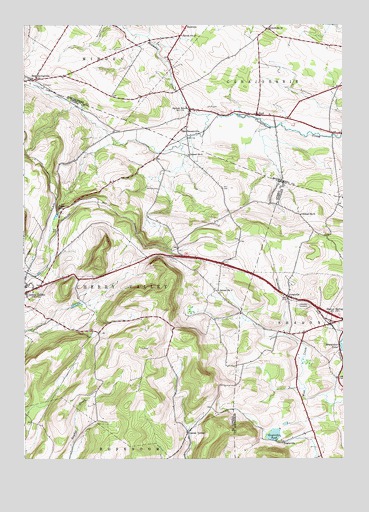
Sprout Brook, NY USGS Topographic Map
Click on map above to begin viewing in our Map Viewer.

This topographic map contains these locations and features:
Feature Name Type Latitude Longitude GNIS ID View Map
Bowmaker PondLakeN42.7824°W74.6251°944524View Map
Bowmans CreekStreamN42.8495°W74.6774°944529View Map
Boyle's LandingAirportN42.8143°W74.6261°978294View Map
BuelPopulated PlaceN42.8492°W74.6590°945103View Map
Center ValleyPopulated PlaceN42.7579°W74.6857°946202View Map
Coleman CemeteryCemeteryN42.8493°W74.6670°947114View Map
EnglevillePopulated PlaceN42.7551°W74.6485°949662View Map
Engleville PondReservoirN42.7570°W74.6523°949663View Map
Flint CemeteryCemeteryN42.8516°W74.6778°950286View Map
Flint CemeteryCemeteryN42.8579°W74.7430°950287View Map
HessvillePopulated PlaceN42.8740°W74.6871°972613View Map
Judds FallsFallsN42.8226°W74.7365°954215View Map
LeesvillePopulated PlaceN42.7970°W74.6468°955175View Map
McFee CemeteryCemeteryN42.8292°W74.6973°956761View Map
Mount IndependenceSummitN42.7937°W74.6950°2791117View Map
Saint Thomas Roman Catholic ChurchChurchN42.7994°W74.7492°2597908View Map
Salt SpringvillePopulated PlaceN42.8592°W74.7457°964334View Map
School Number 12 (historical)SchoolN42.8206°W74.6413°975035View Map
School Number 13 (historical)SchoolN42.8723°W74.6885°975059View Map
School Number 14 (historical)SchoolN42.8740°W74.6543°975088View Map
School Number 2 (historical)SchoolN42.7987°W74.6738°975192View Map
School Number 3 (historical)SchoolN42.8376°W74.6857°975268View Map
Sharon CemeteryCemeteryN42.7941°W74.6396°955176View Map
Sharon OrchardsLocaleN42.7903°W74.6575°2516876View Map
Sprout BrookPopulated PlaceN42.8509°W74.6851°966114View Map
Stone House FarmLocaleN42.8114°W74.6422°2555048View Map
Town of Cherry ValleyCivilN42.8046°W74.7293°978821View Map
Van DeusenvillePopulated PlaceN42.8431°W74.6863°968404View Map
WJIV-FM (Cherry Valley)TowerN42.7934°W74.6943°978506View Map

Note: Coordinates in the location and feature list above are referenced to NAD83 datum.


Copyright (C) 2008-2024 Ryan Niemi / Sunset Dynamics ... All Rights Reserved