TopoQuest Logo
Do you find TopoQuest useful?
Help keep TopoQuest running and adding new maps/features by donating!
Bitcoin:  19c7KJd3qBynnjoSw5npx9KScwjBe4ifkT
Litecoin:  LXs6TkuXGGXo1vDsWCkWVdjQX94eUKd6ui
Home View Maps Find Maps Find Places Resources & Links


Fort Plain, New York Topographic Map

USGS Map Title: Fort Plain, NY
USGS Map MRC: 42074H6
DRG (GeoTIFF) Download: o42074h6.tif


Neighboring USGS Topographic Map Quads:


  Little Falls, NY  
43074A7
 

  Oppenheim, NY  
43074A6
 

  Lassellsville, NY  
43074A5
 

  Van Hornesville, NY  
42074H7
 

  Fort Plain, NY  
42074H6
 

  Canajoharie, NY  
42074H5
 

  East Springfield, NY  
42074G7
 

  Sprout Brook, NY  
42074G6
 

  Sharon Springs, NY  
42074G5


Map MRC Location:

N43°
W75°
N43°
W74°
H8 H7 H6 H5 H4 H3 H2 H1
G8 G7 G6 G5 G4 G3 G2 G1
F8 F7 F6 F5 F4 F3 F2 F1
E8 E7 E6 E5 E4 E3 E2 E1
D8 D7 D6 D5 D4 D3 D2 D1
C8 C7 C6 C5 C4 C3 C2 C1
B8 B7 B6 B5 B4 B3 B2 B1
A8 A7 A6 A5 A4 A3 A2 A1
N42°
W75°
N42°
W74°

Fort Plain, NY USGS 1:24K Topographic Map Preview:
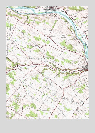
Fort Plain, NY USGS Topographic Map
Click on map above to begin viewing in our Map Viewer.

This topographic map contains these locations and features:
Feature Name Type Latitude Longitude GNIS ID View Map
Abeel IslandIslandN42.9531°W74.6288°973488View Map
Barge Canal BridgeBridgeN42.9923°W74.7175°2614867View Map
Brookman CornersPopulated PlaceN42.9173°W74.7263°944853View Map
Caroga CreekStreamN42.9645°W74.6374°945873View Map
Charlesworth CornersPopulated PlaceN42.9665°W74.6860°946407View Map
Clancy FarmsLocaleN42.9094°W74.6275°2556283View Map
Crum CreekStreamN42.9992°W74.7310°947865View Map
David H Robbins Elementary SchoolSchoolN42.9992°W74.6726°2668828View Map
Di Stefano AirparkAirportN42.9234°W74.6256°978021View Map
Dunkel CemeteryCemeteryN42.8980°W74.6606°948801View Map
Dutchtown SchoolSchoolN42.9784°W74.7140°948876View Map
East Canada CreekStreamN42.9995°W74.7435°970097View Map
Edwards CemeteryCemeteryN42.9895°W74.6461°949406View Map
First Baptist ChurchChurchN42.9303°W74.6253°2401446View Map
First Methodist ChurchChurchN42.9325°W74.6253°2401445View Map
FordsbushPopulated PlaceN42.9595°W74.7421°950381View Map
Fort Klock (historical)MilitaryN42.9850°W74.6494°2571420View Map
Fort Plain CemeteryCemeteryN42.9349°W74.6312°2401272View Map
Fort Plain Central SchoolSchoolN42.9317°W74.6297°2401449View Map
Fort Plank SchoolSchoolN42.9495°W74.6643°950493View Map
FreysbushPopulated PlaceN42.9092°W74.6629°950725View Map
Freysbush CemeteryCemeteryN42.9104°W74.6685°2548155View Map
HallsvillePopulated PlaceN42.9351°W74.7035°952074View Map
Harry Hoag Elementary SchoolSchoolN42.9332°W74.6353°2668858View Map
Hickory Acres AirportAirportN42.8830°W74.6898°978023View Map
Highland Mobile Home EstatesPopulated PlaceN42.9255°W74.6334°2618235View Map
Holy Cross Episcopal ChurchChurchN42.9317°W74.6258°2401450View Map
Keesler CornersPopulated PlaceN42.9176°W74.6796°954439View Map
Klock CemeteryCemeteryN42.9942°W74.6394°954742View Map
Klock SchoolSchoolN42.9853°W74.6479°954747View Map
Margaret Reaney Memorial LibraryBuildingN42.9970°W74.6776°2617343View Map
MindenvillePopulated PlaceN42.9920°W74.7176°957376View Map
Mother CreekStreamN42.9734°W74.6435°957782View Map
Mount Hope CemeteryCemeteryN42.9618°W74.7414°957844View Map
Moyers CornersLocaleN42.9853°W74.7318°957977View Map
Nellis CemeteryCemeteryN42.9948°W74.6561°958360View Map
Nellis FieldAirportN42.9621°W74.6804°978020View Map
O'Riley AirportAirportN42.9760°W74.7304°978022View Map
Otsquene CreekStreamN42.9314°W74.6722°2788145View Map
Palatine ChurchChurchN42.9692°W74.6285°959770View Map
Potter FarmsLocaleN42.8961°W74.7103°2556291View Map
Ripple CornersLocaleN42.8798°W74.7282°962547View Map
River Road SchoolSchoolN42.9828°W74.6621°962557View Map
Saint James Roman Catholic ChurchChurchN42.9333°W74.6289°2401447View Map
Saint John's Reformed ChurchChurchN42.9991°W74.6830°2616941View Map
Saint JohnsvillePopulated PlaceN42.9981°W74.6829°963694View Map
Saint Johnsville Family Health CenterBuildingN43.0000°W74.6884°2614773View Map
Saint Johnsville Post OfficePost OfficeN42.9989°W74.6779°2618102View Map
Saint Johnsville Village Wastewater Treatment PlantLocaleN42.9947°W74.6757°2617756View Map
Saint Johnsville Volunteer Ambulance CorpsBuildingN42.9993°W74.6761°2720171View Map
Saint Paul Lutheran ChurchChurchN42.9992°W74.6803°2616998View Map
Saint Pauls Lutheran ChurchChurchN42.9317°W74.6275°2401448View Map
Sand HillPopulated PlaceN42.9442°W74.6332°964369View Map
School Number 10 (historical)SchoolN42.9120°W74.6549°974952View Map
School Number 11 (historical)SchoolN42.9717°W74.6290°974993View Map
School Number 15 (historical)SchoolN42.9154°W74.7257°975110View Map
School Number 17 (historical)SchoolN42.9284°W74.6540°975139View Map
School Number 3 (historical)SchoolN42.9431°W74.6303°2106771View Map
School Number 6 (historical)SchoolN42.9634°W74.7435°975493View Map
School Number 7 (historical)SchoolN42.9376°W74.7107°975551View Map
Seeber Lane SchoolSchoolN42.8879°W74.6404°964796View Map
Smith CemeteryCemeteryN42.9966°W74.7432°965465View Map
Timmerman CreekStreamN42.9931°W74.6985°967538View Map
Town of MindenCivilN42.9271°W74.6975°979223View Map
Valley BrookPopulated PlaceN42.9290°W74.6590°968355View Map
Victory Christian AcademySchoolN42.9587°W74.7411°2669127View Map
Village of Fort PlainCivilN42.9316°W74.6277°2390847View Map
Walrath CemeteryCemeteryN42.9632°W74.6421°968720View Map
Walts SchoolSchoolN42.9006°W74.6882°968745View Map
West Saint JohnsvillePopulated PlaceN42.9995°W74.7004°970857View Map
West Saint Johnsville CemeteryCemeteryN42.9991°W74.6966°2548154View Map
Wiles CemeteryCemeteryN42.9181°W74.7229°971269View Map
Yerding CemeteryCemeteryN42.8927°W74.6407°971824View Map
Zimmerman CreekStreamN42.9942°W74.6885°971874View Map

Note: Coordinates in the location and feature list above are referenced to NAD83 datum.


Copyright (C) 2008-2025 Ryan Niemi / Sunset Dynamics ... All Rights Reserved