TopoQuest Logo
Do you find TopoQuest useful?
Help keep TopoQuest running and adding new maps/features by donating!
Bitcoin:  19c7KJd3qBynnjoSw5npx9KScwjBe4ifkT
Litecoin:  LXs6TkuXGGXo1vDsWCkWVdjQX94eUKd6ui
Home View Maps Find Maps Find Places Resources & Links


Stahlstown, Pennsylvania Topographic Map

USGS Map Title: Stahlstown, PA
USGS Map MRC: 40079B3
DRG (GeoTIFF) Download: o40079b3.tif


Neighboring USGS Topographic Map Quads:


  Latrobe, PA  
40079C4
 

  Derry, PA  
40079C3
 

  Wilpen, PA  
40079C2
 

  Mammoth, PA  
40079B4
 

  Stahlstown, PA  
40079B3
 

  Ligonier, PA  
40079B2
 

  Donegal, PA  
40079A4
 

  Seven Springs, PA  
40079A3
 

  Bakersville, PA  
40079A2


Map MRC Location:

N41°
W80°
N41°
W79°
H8 H7 H6 H5 H4 H3 H2 H1
G8 G7 G6 G5 G4 G3 G2 G1
F8 F7 F6 F5 F4 F3 F2 F1
E8 E7 E6 E5 E4 E3 E2 E1
D8 D7 D6 D5 D4 D3 D2 D1
C8 C7 C6 C5 C4 C3 C2 C1
B8 B7 B6 B5 B4 B3 B2 B1
A8 A7 A6 A5 A4 A3 A2 A1
N40°
W80°
N40°
W79°

Stahlstown, PA USGS 1:24K Topographic Map Preview:
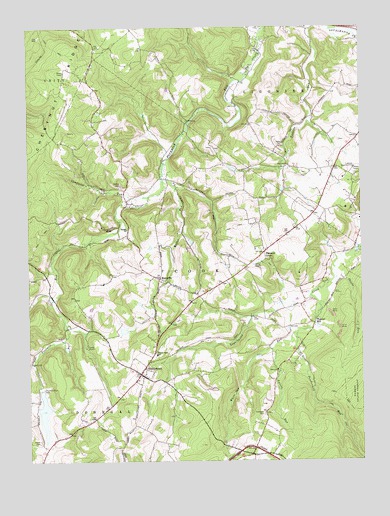
Stahlstown, PA USGS Topographic Map
Click on map above to begin viewing in our Map Viewer.

This topographic map contains these locations and features:
Feature Name Type Latitude Longitude GNIS ID View Map
Bethel CemeteryCemeteryN40.2023°W79.3384°1169357View Map
Bethel ChurchChurchN40.1917°W79.3373°1169379View Map
Breskin Dam Number TwoDamN40.2284°W79.3214°1194652View Map
Breskin PondReservoirN40.2322°W79.3219°1194655View Map
Breskin Pond Dam Number OneDamN40.2317°W79.3214°1194654View Map
Camp WescoLocaleN40.1584°W79.3528°1171113View Map
Campbelle RunStreamN40.2012°W79.3292°1171139View Map
Chestnut RidgeRidgeN40.2334°W79.3664°1200574View Map
Chestnut Ridge Community Volunteer Fire DepartmentBuildingN40.1546°W79.3286°2644942View Map
Enoch Stahl SchoolSchoolN40.1556°W79.3270°1174273View Map
Four Mile Run DamDamN40.1457°W79.3704°1194912View Map
Fourmile Run DamDamN40.1454°W79.3703°1175065View Map
Keffer RunStreamN40.2062°W79.3239°1178298View Map
Laurel RunStreamN40.1579°W79.2842°1178977View Map
Ligonier Country ClubLocaleN40.2095°W79.2520°1213267View Map
MansvillePopulated PlaceN40.1776°W79.3253°1180308View Map
Mill CreekStreamN40.2490°W79.2531°1181153View Map
Mutual Aid Ambulance Service Chestnut RidgeBuildingN40.1546°W79.3286°2719512View Map
Phoebe RunStreamN40.1776°W79.2600°1183685View Map
Pleasant GrovePopulated PlaceN40.1851°W79.2859°1184011View Map
Porch CemeteryCemeteryN40.1306°W79.3709°1184269View Map
Powdermill RunStreamN40.1620°W79.2739°1193159View Map
Ridge School (historical)SchoolN40.2195°W79.3348°1205491View Map
Snowball CemeteryCemeteryN40.1390°W79.2867°1187947View Map
StahlstownPopulated PlaceN40.1501°W79.3328°1188383View Map
Stahlstown Post OfficePost OfficeN40.1499°W79.3320°2772990View Map
Township of CookCivilN40.1676°W79.2877°1217234View Map
Weaver SchoolSchoolN40.1667°W79.2648°1205490View Map
White Oak RunStreamN40.1726°W79.2689°1191306View Map
Zion ChurchChurchN40.2167°W79.2792°1191980View Map

Note: Coordinates in the location and feature list above are referenced to NAD83 datum.


Copyright (C) 2008-2025 Ryan Niemi / Sunset Dynamics ... All Rights Reserved